Back to forecast
Final June Weekend Weather Preview
June 28, 2018 at 02:40 PM EDT
By WeatherBug Sr. Meteorologist, James West
A hot summer weekend will be in full swing for many parts of the U.S., with major storms erupting in the heat and only a few mountainous and spots seeing comfortable temperatures. Beaches, lakes and pools will be the trendy hot spots.
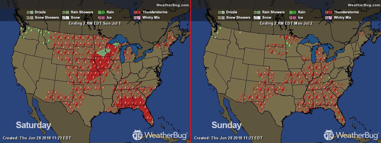
Saturday
Hot weather will be the norm, not the exception for most of the U.S.’s Southwest, Plains and East. The mercury will easily reach into the 90s from the Great Plains to the Atlantic, with high 90s and triple digit readings found throughout California, the Desert Southwest, southern Rockies, Four Corners, central Plains, Rio Grande Valley and into the Great Lakes and the Mid-Atlantic.
Add in summer humidity, and the heat index will easily exceed 100 degrees, with 105 to 110 readings possible across the southern Plains, Southeast and throughout the Great Lakes and East Coast. A stray shower and thunderstorm could bring temporary heat break to the South and Southeast. These high heat index values can be dangerous to the elderly, children and animals.
Significant afternoon relief will come in the form of widespread thunderstorms across the north-central Plains and the Upper Midwest. The hot temperatures and humidity will energize these storms, so damaging winds, large hail and gully-filling downpours will accompany these storms. A large storm complex will evolve overnight Saturday, bringing the storm threat to more of the central Plains and Midwest. The cooling effect of the storms will mean that temperatures will only be in the 70s and 80s in the Dakotas.
If you’re seeking comfortable temperatures, the sun-kissed Rockies, Intermountain West and Northwest will be the place to be. Highs will be in the 70s and 80s.
Sunday
The hot weather will stick around on Sunday for most of the U.S.
The axis of hottest and steamiest weather does shift slightly between Saturday and Sunday. High temperatures will be in the upper 90s to near 100 degrees throughout the Northeast and Mid-Atlantic, with the heat index reaching 105 to 110 degrees throughout the highly populated I-95 corridor from Washington, D.C., to southern New England.
The South, Southeast, southern and central Plains and Midwest will also be in the 90s, but a few thunderstorms could bring relief to the Upper Midwest, western Great Lakes, Southeast and Florida. The storms that hit the western Great Lakes and Upper Midwest could produce flash flooding, large hail and damaging winds.
The western half of the U.S. will continue to be filled with sunshine Sunday, with California, the Southwest, southern Great Basin and the southern Rockies will be in the 90s and triple digits. The Northwest, northern Intermountain West and northern Rockies will be in the 70s and 80s. Some of the mild weather will spill out into the western high Plains of the Dakotas and Montana, with highs in the 80s.