Back to forecast
Weekend Weather Preview
November 21, 2024 at 04:09 PM EST
By WeatherBug's Keegan Miller
The weekend before Thanksgiving, a contrast grows between dry weather to the east and rainy, snowy skies to the west.
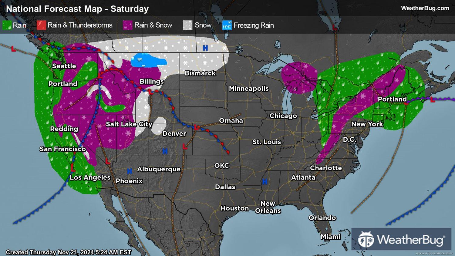
Saturday
The bulk of inundating rainfall and snow additions from the West Coast's Pineapple Express should conclude by Saturday afternoon in northern California. Still, hefty winds and precipitation will oscillate through the Pacific Northwest and northern Rockies throughout the day.
Totals for rain will be under an inch for most locales but expect an inch or higher for rain showers near Olympia, the northern Cascades, the Klamath Mountains, and the Sierra Nevada Range. Deep snow is still expected to build across the higher elevations and on interior Northwestern peaks through western Montana, with middle elevations seeing a wintry mix. Most of central and western Washington expect minor, at most, additions in precipitation.
In the Northeastern U.S., a low pressure system makes a northeastward exit, causing precipitation in the region to follow suit. Snow, wintry mix, and flurries will wane in Appalachia and the Great Lakes through Saturday morning, but rain and snow alike will persist through much of the afternoon along New England's coastline. Southern New England will face the brunt of accumulating rainfall, with up to an inch of rain along its east coast and lesser showers elsewhere. Into Saturday night, spotty snow and wintry mix persist only in the interior Northeast.
Another gusty day across the Northeast and Northwest is in session for Saturday. Wind gusts of 40 to 50 mph will be common for many areas in the Pacific Northwest, but locally higher wind gusts are possible. Gusts exceeding 30 mph are more likely in the Northeast.
Fortunately for the rest of the nation, drier conditions mix into the fray. High pressure will result in sunny skies across the southern corridor while a lack of moisture lasts in most of the Great Plains and Upper Midwest. Only scattered, spotty snowfall could arise in North Dakota.
As for the temperatures, sweater weather pushes slightly northward in the U.S. on Saturday. Highs in the upper 60s, 70s, and isolated 80s warm the Desert Southwest, South Florida, and most of Texas. More moderate temperatures, peaking from the 50s and lower 60s, dominate the central Plains, the southern Pacific coast, the Deep South, and the Southeast.
Cooler temperatures, reaching 40s and upper 30s, chill the Pacific Northwest, the Rocky mid-elevations, the northern Plains, and the Midwest through the New England coastline. However, some spotty sub-zero highs roll in the interior Northeast's highlands. A larger swath of freezing highs keeps near the Canadian border from Minnesota through the Cascades, with mountaintops through the West holding highs in the high teens at their coldest.
Sunday
A mixed bag of dryness and unsettled, moderate precipitation pervades the West as the atmospheric river and cyclone lose their edge on Sunday.
Only parts of the Northwestern coast will see rain totals exceed half an inch with scattered light-to-moderate rain expected elsewhere. One heavy band of showers will launch totals exceeding three inches over parts of northwestern Oregon and southwestern Washington. Peaks across the central Rockies and the Sierra Nevada range still expect to see building snowpack, though to a lesser extent than previous days. The heaviest precipitation across the West Coast accompanies the afternoon. Strong winds in excess of 25 mph will be widespread through the Northwest, with gusts exceeding 35-40 mph.
East of the Rockies, only the interior Northeast should expect any rain, snow, or mix on Sunday morning, with clear weather expected otherwise in most areas. However, some isolated light showers could spawn in the Upper Midwest in the late afternoon hours onward.
Brisk Canadian air will fight warmer temperatures attempting their return into the States on Sunday. Eighties and 70s will heat up Texas, the Desert Southwest, Florida, and the Gulf Coast, while 50s and 60s warm the southern Pacific coast, the South, the mid-Mississippi Valley, and the central Plains.
Chiller 40s and upper 30s give way in the Northeast, Great Lakes, Upper Midwest, north-central Plains, and the lower-to-middle elevations of the West. High temperatures sticking to the freezing line and below will mark the interior Northeast as well as the western highlands, their peaks, and the far northern High Plains, where some locales chill into the teens.