Weekend Weather Preview
Wintry weather conditions freeze areas nationwide as widespread snow, rain, and icy conditions plague weekend plans.
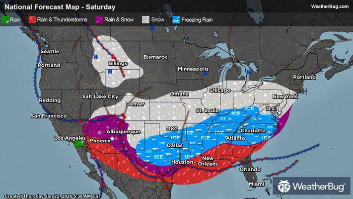
Saturday
In the Northeast, mostly dry conditions are expected on Saturday, with exception of the U.S.-Canada border. Here, there could be a few snow showers persist from Friday. The Mid-Atlantic will also be dry throughout most of the day, then snow overspreads the region in the evening and overnight.
Rain will impact weekend plans across much of the Southeast and Gulf Coast, with light showers filling the area Saturday morning. There is a possibility for some thunderstorms to populate along the coast of Texas, with localized heavier rain expected with these storms. However, the Carolinas and southern Appalachians will likely see freezing rain or a mix of rain, freezing rain, snow and sleet.
The Midwest unfortunately cannot have a snow-free weekend, as Saturday is expected to be quite snowy for the Central Plains. For a change, the U.S.-Canada border and Great Lakes will remain relatively snow-free during the day on Saturday, with minimal precipitation until overnight hours into Sunday.
There will be a significant amount of snow over the Central Plains, primarily encompassing Kansas and Oklahoma with amounts over 10 inches. There will be a few inches of snow in the states surrounding Kansas and Oklahoma, but the possibility of dangerously icy conditions will encompass northern Texas, southern Oklahoma, and Arkansas.
In the Mountain West, the southern Rockies will receive a generous snowfall on Saturday, bringing ideal conditions for skiers looking to hit the slopes this weekend. The northern Rockies will experience a drier Saturday than its southern portion, with dry conditions aside from some snowfall atop the higher mountainous peaks.
The Desert Southwest will be a bit “desert south-wet” this Saturday. Lighter rainfall will impact southern California and southwestern Arizona, while localized higher amounts of rainfall with possibilities for some thunderstorms will be present among southeastern Arizona into New Mexico.
The rest of the West Coast will be dry, except for the Oregon Coast and Willamette Valley. Although some rainfall is possible here, precipitation amounts will be quite low, and it will mostly just call for a wet, muggy day.
Temperatures in the negative teens will plague North Dakota, Minnesota, and northern Wisconsin. Single digit negatives will be experienced along the U.S.-Canada border in the Northeast, as well as South Dakota, Iowa, and Wisconsin. Single-digit temperatures are in areas surrounding the Great Lakes and throughout the Central Plains. Areas with temperatures in the teens will be the Atlantic coast through southern New jersey, as well as areas west of the Appalachian Spine down through to Arkansas. The Rockies will also experience temperatures in the teens throughout the day on Saturday
Areas in the 20s and 30s will be the southern Mid-Atlantic, northern portion of Gulf Coast states, the Great Basin Desert, and the Pacific Northwest. Forty-degree temperatures will be seen along the middle portion of Gulf Coast states, northern California, and the foothills of Sierra Nevada. Fifties and 60s will be common for the Gulf Coast, California’s Central Valley, and the Desert Southwest.
Warmer than the rest this Saturday will be southern Florida and the Rio Grande Vallet, of whom will see temperatures in the mid to high 70s.
Sunday
Sunday weather conditions will hold wet, wintry weather for most of the nation, setting up poor travel conditions for the day. A cozy day at home will be on the agenda for many!
In the Northeast and Mid-Atlantic, weather conditions will shift drastically throughout the day as a low pressure system sweeps significant snowfall amounts into the area. In the morning hours, most of the significant snowfall amounts will cling to the Mid-Atlantic and Appalachian spine.
New England will remain primarily dry in the morning hours until snow begins to settle in by midday, intensifying in the evening hours on Sunday. Northern New York up into Maine will be dry until snowfall makes its way northward into New York, bringing snow up to Maine by the evening. As this snowfall makes its way northward, snow will accumulate and leave over 10 inches of snowfall in the low pressure system’s path. Southern New York, Connecticut, Rhode Island, and Massachusetts will see impacts from this snowfall accumulation into Monday morning’s commute.
The Mid-Atlantic will see continued snowfall from Saturday night, increasing accumulation amounts in the low pressure system’s path. Accumulation will be greater along the Atlantic coastline, but accumulation over 10 inches will continue to stick along the Appalachians as well. Another concern for the Mid-Atlantic will be icy conditions that persist along southern Virginia as the low pressure system passes. These icy conditions will extend down into North Carolina and northern South Carolina as well.
In the Southeast and Deep South, there will be a mix of every type of precipitation as wintry conditions extend far down south. An inch or two of snowfall will impact most of the northern portions of the southern states, including Tennessee, Arkansas, Texas, and the states southward along the borders of these states. Southward of the borders, there is the possibility for some icy conditions.
There will be an increased amount of rainfall along with a squall line of thunderstorms that impact southern Texas, Louisiana, Mississippi, Alabama, and Georgia, with the panhandle of Florida included as well. Localized heavy rain will accompany these storms, bringing unideal weather into the area as a wrap to the weekend.
The Midwest can expect continued wintry weather like Saturday, but snowfall's accumulation amounts will be significantly lower. The Great Lakes region will get their share of snowfall Sunday as the low pressure system progresses across the East Coast. Southern Illinois, Indiana, Ohio, and the entirety of Kentucky will see a localized higher snow accumulation amount, nearing up to 10 inches. The Central Plains will see another few inches of snow, but the Northern Plains will once again be primarily dry.
In the Mountain West, there will be a continuation of snowfall in the southern Rockies, while the northern Rockies will be primarily dry. There is more opportunity for some light rainfall to lowland areas in the northern Rockies, but most of the precipitation that the northern Rockies see will be in the higher elevated mountainous peaks.
The Desert Southwest will see a continuation of light rainfall like Saturday, but this will end near midday. Southeastern Arizona and the New Mexico border will continue to see localized higher rainfall amounts through the day, tapering off by the evening hours on Sunday.
The remainder of the West Coast will be dry throughout most of the day on Sunday, with some light showers impacting the Washington and northern Oregon coasts, also stretching to the Cascades.
Temperatures in the negative teens will plague the U.S.-Canada border along Wisconsin. Single digit negatives will be experienced in most of North Dakota, northern South Dakota, and Wisconsin. Single digit temperatures can be found along the U.S.-Canada border in the Northeast, as well as Wisconsin, Iowa, and South Dakota. Areas with temperatures in the teens will be Northeast, areas surrounding the Great Lakes, the Central Plains, and higher elevations in the Rockies.
Areas in the 20s will be the Mid-Atlantic down through the Appalachian spine, into southern Texas. The lowland areas within the Rockies will also see temperatures in the 20s. The Southeast, coast of Texas, Great Basin Desert, and Pacific Northwest will see temperatures within the 30s this Sunday. Forty-degree temperatures will be seen along the Rio Grande Valley, the coasts of Louisiana, Mississippi, Alabama, and Florida’s Panhandle and southern Georgia in the South. Other areas out West in the 40s will be northern California. Fifties and 60s will be common for the northern Florida, California’s Central Valley, and the Desert Southwest.
Southern Florida will beat out the heat with temperatures in the high 70s, even reaching the 80s in some areas!