Back to forecast
Weekend Weather Preview
March 14, 2024 at 02:18 PM EDT
By WeatherBug Meteorologist, Alyssa Robinette
Mother Nature will supply plenty of soggy, wintry weather for most of the nation this weekend. A few spots are in luck, though, if you have outdoor plans.
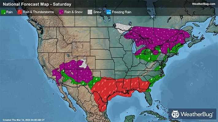
Saturday
The southern half of the U.S. will be under the influence of two weather systems on Saturday. The first will be an upper-level weather system that has been “cut-off” from the normal weather flow and will hover over the Southwest. The second will be a cold front draped across the southern Plains, Deep South and Southeast.
Temperatures will be cold enough for snow in the higher elevations of the Four Corners region. Otherwise, rain showers will soak the rest of the southern U.S. from California to the Southeast. A few thunderstorms also cannot be ruled out. The best chance for any precipitation will occur in the Four Corners region and southern Plains.
A clipper-type system will be dropping south across the north-central U.S. Most places should just see occasional rain showers. However, there will be a chance for snow across far northern Minnesota and Michigan’s Upper Peninsula.
Some wintry precipitation could be found across interior New England early in the day. Precipitation would likely be a mix of rain, snow and freezing rain.
A few spots should stay dry for the start of the weekend. This includes the Northwest, northern Rockies and northern Plains. Most of the Midwest, Ohio Valley and Mid-Atlantic should be in the clear.
Temperatures will only be in the 20s and 30s for the highest elevations of the Rockies, the extreme Upper Mississippi Valley and the higher elevations of northern New England. Expect 40s and 50s for the rest of the Mountain West, the northern half of the Plains, Great Lakes and the rest of the Northeast. Milder 60s and 70s will be reported along the West Coast into the Desert Southwest, the southern half of the Plains and Mississippi Valley, Midwest, Ohio Valley, Mid-Atlantic, Deep South and Southeast. Parts of Texas and Florida will also see widespread 80s!
Sunday
Sunday will be a near repeat of Saturday's weather. Expect the “cut-off” low to remain nearly stationary over the Southwest, while an elongated cold front is draped over the southern Plains, Deep South and Southeast. The clipper-type system will be advancing east into the Great Lakes and Northeast.
This will translate into more rain and mountain/higher elevation snow for the central/southern Rockies and Southwest. The southern Plains, Gulf Coast and Southeast will be drenched in even more showers and thunderstorms. After a few days of rainy weather, be on the lookout for some localized flooding, mainly in the southern Plains and Lower Mississippi Valley.
There will be a good chance for rain and mountain snow showers across the Northeast, with a small chance for rain in the Mid-Atlantic and Ohio Valley. Flurries or light snow showers are possible across the Great Lakes. The best chance for will occur downwind from Lake Michigan and Lake Superior.
Outside of these areas, largely dry weather is expected for the conclusion of the week. This includes most of California into the Northwest and northern Rockies as well as the northern half of the Plains, Upper Mississippi Valley and Midwest.
Colder air will be infiltrating southward across a large portion of the Northern Tier. Expect 20s and 30s for the northern Plains, Upper Mississippi Valley and Great Lakes. The tallest peaks in the Rockies will also top out in the 20s and 30s. There will be 40s and 50s for the rest of the Mountain West into the central Plains, Midwest, Ohio Valley and Northeast. Sixties and 70s will remain dominant across the West Coast and Desert Southwest as well as the southern Plains, Deep South, Southeast and Mid-Atlantic. Eighties will also continue throughout Florida.