

Weekend Weather Preview
After an active week of weather, Mother Nature has no plans of mixing up the weather pattern across the U.S. this weekend. Soggy, stormy weather persists for all areas along and east of the Rockies, while generally unseasonably warm and dry weather continues in the West.
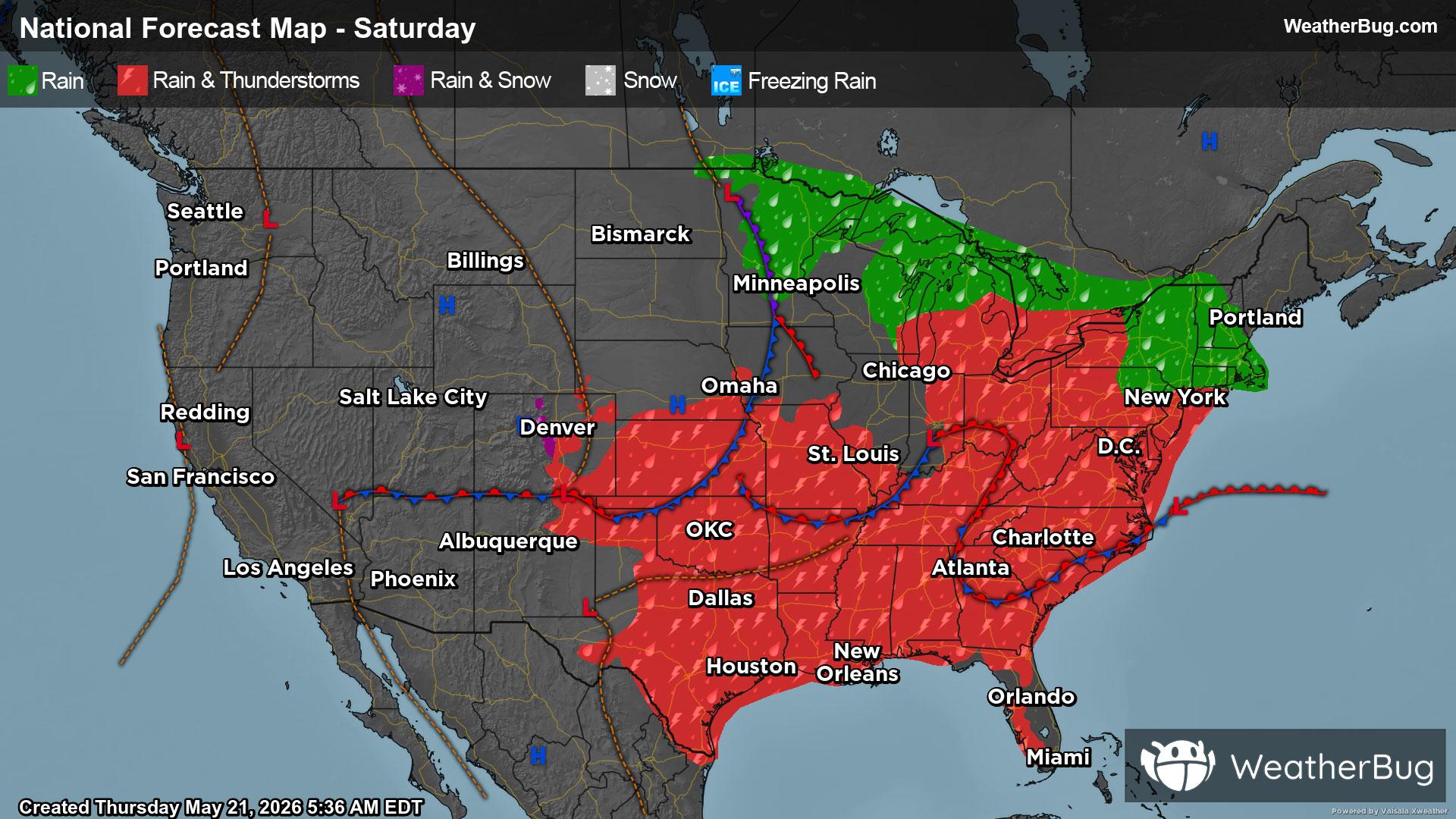
Saturday
A series of fast-moving weather disturbances and cold fronts will impact the Central and Eastern U.S. for the start of the weekend. As a result, most areas east of the Rockies will see chances of rain and thunderstorms. While possible at any point in the day, the best chance of rain and thunderstorms will occur in the afternoon and evening. However, the Ohio Valley and Mid-Atlantic will be the exception as widespread, steady or nearly steady rain is likely throughout the entire day.
A few spots could be at risk of strong to severe thunderstorms. This includes most of the Plains and Deep South. Damaging wind gusts exceeding 60 mph will be the main concern within thunderstorms. Large hail and an isolated brief tornado cannot be ruled out.
In addition, slow-moving and repeated rounds of moderate to heavy rain will be a possibility from the central Gulf Coast into the Ohio River Valley and Mid-Atlantic. Rainfall amounts of 1 to 3 inches may quickly fall, with some locally higher amounts possible. This will trigger worries for flooding, especially near rivers, creeks and streams as well as urban, low-lying and other more flood-prone areas. If you do approach a flooded roadway, remember that it is always best to “Turn Around, Don’t Drown!”
Meanwhile, there is a slight chance of showers in the Great Basin, but the rest of the West will remain free of precipitation to start the weekend. Eastern portions of New England will also likely remain dry.
The Mid-Atlantic and Appalachian Spine will be the coolest spot in the U.S. on Saturday, with highs in the 40s and 50s. The tallest peaks in the Rockies could also see temperatures peak in the 40s and 50s. New England, the Great Lakes and the rest of the Rockies will end up with highs in the 60s. Seventies and 80s will be in the forecast for the rest of the U.S., but 90s will occur in parts of Florida, western Texas, the Desert Southwest and California’s Central Valley.
Sunday
The weather disturbances and cold fronts from Saturday will shift eastward on Sunday. This will keep the bulk of rain and thunderstorms in the south-central U.S. and East. Though, isolated showers and storms will still be possible across the rest of the Plains and Mississippi Valley. Like Saturday, there will be chances of rain and thunderstorms throughout the day, but the best chance will occur in the afternoon and evening.
Severe weather will be possible across the northern Plains and Upper Mississippi Valley, with a lesser chance of potent thunderstorms in the Southeast. Within thunderstorms, the main threats will be destructive winds and large hail. Isolated, brief tornadoes could also develop.
At the same time, a new cold front will push into the Northwest on Sunday. This could trigger some showers across the Mountain West. Coastal areas of the West Coast into the Southwest will remain largely dry.
High temperatures will once again only reach the upper 40s, 50s and lower 60s across the Northeast and the higher elevations of the Rocky Mountains. Expect 60s and 70s throughout the Great Lakes, the Mississippi and Ohio valleys and the Mid-Atlantic as well as the rest of the Rockies, Great Basin and Northeast. Eighties and 90s are in store for California and Desert Southwest into the Plains and Southeast.