


Weekend Weather Preview
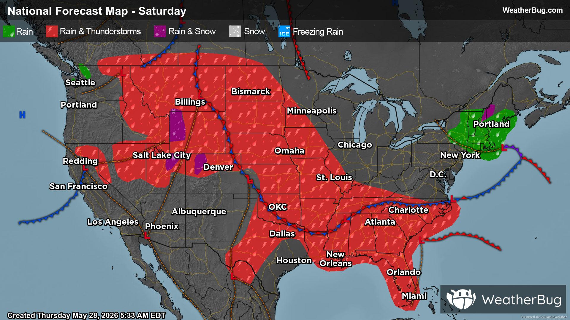
We are just days away from the start of “meteorological” summer, but spring-like temperatures will be in store for large parts of the U.S. this weekend. A soggy forecast will also continue, and there could even be some mountain snow.
Saturday
A cold front will be stalled over the eastern two-thirds of the U.S. on Saturday, stretching from the Southeast and south-central U.S. into the Rocky Mountains and High Plains. There will also be a second cold front inching across the Northwest and Great Basin.
Rain and thunderstorms will be found along both cold fronts, including the Mountain West, the northern and Central Plains, Mississippi Valley and Southeast. However, temperatures could be cold enough for wet snow or a rain/snow mix throughout the tallest peaks of the Rockies, best chance early and late in the day.
Slow-moving, repeated rounds of moderate to heavy rain will be a possibility along this stalled cold front. Rainfall amounts of 1 to 3 inches will be common along this cold front, best chance in the northern Rockies, northern Plains and Southeast. Flooding could develop as a result, especially near rivers, creeks and streams as well as urban or low-lying, more flood-prone areas. If you were to approach a flooded roadway, it is always best to “Turn Around, Don’t Drown!”
Across the Plains, thunderstorms will also have the potential to be strong to severe. Damaging winds and large hail will be the main concern within thunderstorms. Though, an isolated tornado or two cannot be ruled out.
Meanwhile, a low pressure system will drift from the Northeast into Atlantic Canada. Precipitation will be likely across the Northeast in the morning and afternoon, before tapering off and ending in the evening. Mild temperatures will be in place for most of the regions, meaning rain will be the predominant precipitation type. Higher elevations in the Green and White mountains will be cold enough for wet snow in the morning, which will switch over to rain by the afternoon.
There will be a slight chance of showers and thunderstorms in the southern Plains and Northwest. Otherwise, dry weather will prevail across the immediate West Coast into the Southwest. The Great Lakes, Ohio Valley and Mid-Atlantic will also see a quiet start to the weekend.
Near to above normal temperatures will be reported throughout the nation’s midsection, while unseasonably cool weather dominates across both coasts.
The Northeast will be the coolest spot on Saturday, with highs generally in the upper 40s, 50s and lower 60s. Western Washington, western Oregon and the tallest parts of the Rockies will also end up with temperatures in the upper 40s to lower 60s. Sixties and 70s will in store for large parts of the U.S., including the interior Northwest, Great Basin and lower elevations of the Rockies into the Midwest, Mid-Atlantic and Southeast, with isolated 80s for Florida and the eastern Gulf Coast. Eighties and 90s bake most of California into the Desert Southwest along with the central/southern Plains. A few triple-digit highs will also be a possibility.
Sunday
There will continue to be a stalled cold front that impacts most of the U.S. on Sunday, draped once again from the Southeast into the central/northern Plains and Rocky Mountains. A new low pressure system will also develop along this cold front, which will push into south-central Canada throughout the day.
Rain and thunderstorms will once again be likely from the Southeast and Mississippi Valley into the northern Plains and northern Rockies. Expect just a slight chance of showers and thunderstorms for the southern Plains and the rest of the Rockies. The one exception will be the northern Rockies in western Montana and northwestern Wyoming, where it will be cold enough for precipitation to fall as snow.
Like Saturday, dangerous thunderstorms and torrential downpours will be a possibility along the stalled front. The northern half of the Plains and much of the Mississippi Valley will have the best chance of severe weather. Be prepared for strong winds and large hail within thunderstorms. A brief tornado or two could also be a possibility. The best chance for heavy rain and localized flooding will occur in the Southeast and northern Rockies.
At the same time, a fast-moving weather system will dart across the Northeast. Rain and a few thunderstorms will become increasingly likely during the afternoon and evening.
The Great Lakes and Ohio Valley will continue to have quiet weather for the second half of the nation, while most areas along and west of the Rockies remain free of precipitation.
Sunday’s temperatures will closely resemble Saturday’s. The Northeast as well as the Northwest into much of the Rockies will have temperatures peak in the 50s and 60s. However, the highest peaks of the Cascades and Rockies could only see highs in the 30s and 40s. Seventies and 80s will be widespread throughout the U.S., including the internal Northwest and Great Basin into the Upper Midwest and the rest of the Eastern U.S. Though, a few 80s are possible in Florida. Hot 90s to 100s will be in the forecast for the Desert Southwest as well as the central and southern Plains into the Lower Mississippi Valley.