


Weekend Weather Preview
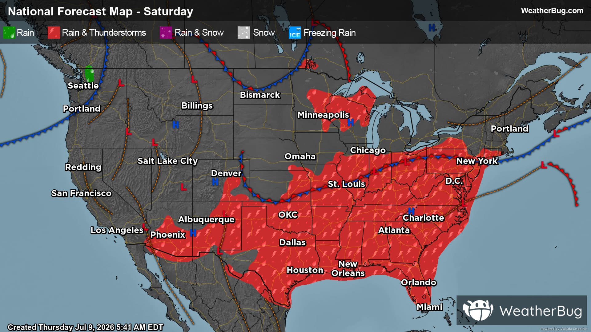
The weekend picks up where the work week left off as multiple cold fronts drift over much of the central and eastern U.S., creating rain and thunderstorm chances. Meanwhile, hot and dry weather prevails in the West.
Saturday
A stationary front will remain draped over the eastern two-thirds of the U.S. The best chance for rain and thunderstorms will occur along this front from the central/southern High Plains into Tennessee Valley, Mid-Atlantic and Southeast. There will be a lesser chance of showers and thunderstorms in the north-central U.S. or the Northeast.
Thunderstorms could turn strong to severe from the central Plains into the Tennessee Valley. The main concern within these potent thunderstorms will be damaging winds. However, large hail and a brief tornado or two cannot be ruled out.
As if that wasn’t enough, repetitive rounds of moderate to heavy rain and/or torrential downpours will be likely for the Tennessee Valley and Mid-Atlantic. Rainfall amounts of 1 to 3 inches could quickly fall, with locally higher amounts possible. After several days of soggy, stormy weather, flooding concerns will be elevated heading to the weekend, especially near rivers, creeks and streams along with urban, low-lying and other more flood-prone areas. Remember to “Turn Around, Don’t Drown!” if you approach a flooded roadway.
On the opposite side of the nation, strengthening high pressure will promote dry weather throughout much of the West. A few showers are possible in western Washington, mainly in the afternoon and evening. Monsoonal moisture is also starting to creep into the Southwest. Isolated to scattered showers and thunderstorms are possible in southern Arizona and most of New Mexico.
Highs in the 70s and 80s will be found across the Upper Midwest and Northeast. The tallest peaks of the Appalachian Spine could only see temperatures peaking in the 60s. Expect upper 80s and 90s for the Lower Midwest, Southeast and Mid-Atlantic. Parts of the Southeast could even see high temperatures exceeding 100 degrees. High humidity combined with these temperatures will make it feel even hotter, so make sure to stay hydrated and wear light, loose clothing if you have outdoor weekend plans.
Highs in the 80s and 90s will be widespread throughout the West and central U.S. Though, the tallest peaks of the Mountain West and coastal areas on the West Coast will record temperatures peaking in the 60s and 70s. Several areas will see triple digit heat, including California’s Central Valley, the Desert Southwest, Great Basin and Plains. Temperatures will generally remain between 100 to110 degrees, but isolated spots could report highs exceeding 110 degrees.
Sunday
A “rinse and repeat” weather pattern is in store for much of the U.S. for the second half of the weekend. A stationary front will remain settled over the south-central and southeastern U.S. A few weaker cold fronts could also clip parts of the Northern Tier as they move across southern Canada.
Rain and thunderstorms will mainly be limited to the southern half of the Plains and Mississippi Valley, the Tennessee Valley, Gulf Coast and Southeast. A few gusty thunderstorms are possible in these regions. Though, heavy rain will be the main concern, especially after many days of soaking rain. Concerns for the flooding will continue through at least the end of the weekend.
Isolated showers and thunderstorms are possible along the U.S.-Canada border, mainly in the far northern Plains, Upper Mississippi Valley and Upper Great Lakes.
At the same time, an upper-level ridge of high pressure will expand over much of the U.S. on Sunday. This will largely promote dry, quiet weather. A few showers and thunderstorms could develop in the Pacific Northwest. Monsoonal moisture will also continue to gradually stream northward, triggering additional rain and thunderstorms chances in both Arizona and New Mexico.
Seventies and 80s will remain in the forecast across the Lower Midwest into the Mid-Atlantic and Northeast. The Northwest and tallest peaks of the Mountain West will also generally see 70s and 80s. Otherwise, 90s will be widespread throughout the U.S. Several spots will see triple digit heat, including California’s Central Valley, the Desert Southwest, Great Basin and northern Plains. Most spots will remain around 100 to 110 degrees, but isolated spots could see highs exceeding 110 degrees. Parts of southern Texas could also see some spots exceed 100 degrees.