Back to forecast
Weekend Weather Preview
October 16, 2025 at 05:50 PM EDT
By WeatherBug Meteorologist, Alyssa Robinette
A one-two punch of weather systems will impact the U.S. this weekend. A soggy forecast is in store for the Central U.S. to start the weekend, while the coasts become more unsettled by Sunday.
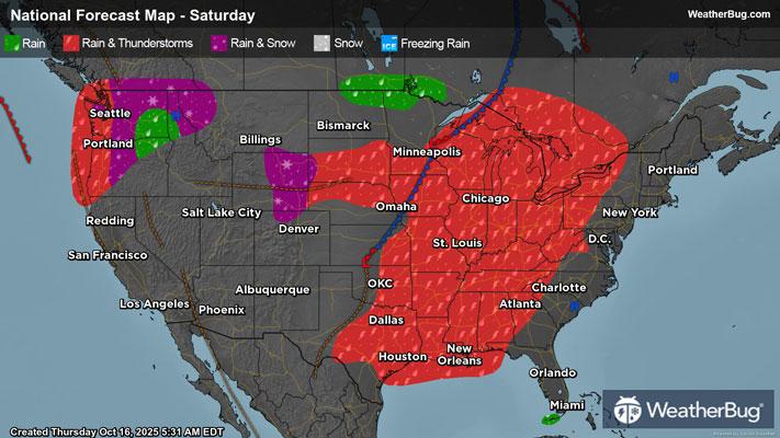
Saturday
A potent weather system and cold front will move across the nation’s midsection on Saturday. Most rain and thunderstorms will be found along the cold front from the Great Lakes and Midwest into the southern Plains and Lower Mississippi Valley. There will be a smaller chance for showers behind the cold front in the northern Rockies and the northern half of the Plains, mainly in the afternoon and evening. A few wet snowflakes could fly onto the tallest peaks of the northern Rockies.
Severe weather will be possible along the cold front, especially for the Lower Mississippi Valley. The main concerns within thunderstorms will be damaging wind gusts and large hail. However, an isolated tornado or two cannot be ruled out. Torrential downpours may also develop, which would lead to some localized flooding.
Meanwhile, a new storm system will come barreling into the Northwest. Rain showers will become increasingly likely throughout the Northwest in the afternoon and evening. Temperatures could also be cold enough for wet snow or a rain/snow mix in the highest elevations of the Cascades.
A ridge of high pressure will be settled over the Eastern U.S., fostering dry weather. High pressure will also keep things quiet across California into the Great Basin, the central/southern Rockies, and the Desert Southwest.
The coldest spots will be found throughout the Rockies and Northern Tier, with highs generally in the 50s and 60s. However, the tallest elevations will only see temperatures in the 30s and 40s! Expect 60s and 70s for the Great Basin, most of the Great Lakes, Midwest, Mid-Atlantic, and Southeast. Eighties are expected for the Ohio and Tennessee valleys, much of California, and the Desert Southwest, while a few 90s are possible across the southern Plains.
Sunday
The weather system and cold front will slide across the Eastern Seaboard on Sunday. Rain showers and thunderstorms will soak the Great Lakes, Midwest, and Deep South during the morning. This rain and thunderstorms will spread to the Ohio Valley, Mid-Atlantic, and Southeast by the afternoon and evening. A few rain showers could also make it into western portions of the Northeast by late Sunday evening.
Like Saturday, a few thunderstorms in the Deep South and Southeast could become strong to severe. Damaging wind gusts and large hail will be the primary concerns. Though an isolated tornado or two will still be possible. Heavy rainfall and localized flooding will also be a possibility, especially in the Ohio River Valley.
On the opposite side of the country, a Pacific storm system will continue to push across the Northwest, making its way into the northern Rockies by late in the day. Expect rain and mountain snow across the Northwest throughout the day, with rain and higher elevation snow arriving in the northern Rockies during the afternoon and evening.
High pressure will build over the Central U.S. for the conclusion of the weekend. Expect dry weather throughout the Plains and Mississippi Valley. No weather concerns are anticipated across California into the Desert Southwest.
Temperatures will reach the 50s and 60s for the Northwest, Great Basin, and Rockies into the northern half of the Plains, Great Lakes, Midwest, and Northeast. Seventies and lower 80s cover much of California, the southern Plains, Deep South, Southeast, and Mid-Atlantic. The Desert Southwest, far southern Plains, and much of Florida, though, will experience 80s to lower 90s.