Back to forecast
Weekend Weather Preview
November 21, 2025 at 05:46 AM EST
By WeatherBug Meteorologist, Alyssa Robinette
A busy, soggy weather forecast awaits most of the U.S. this weekend, but a few spots stay free of any weather concerns.
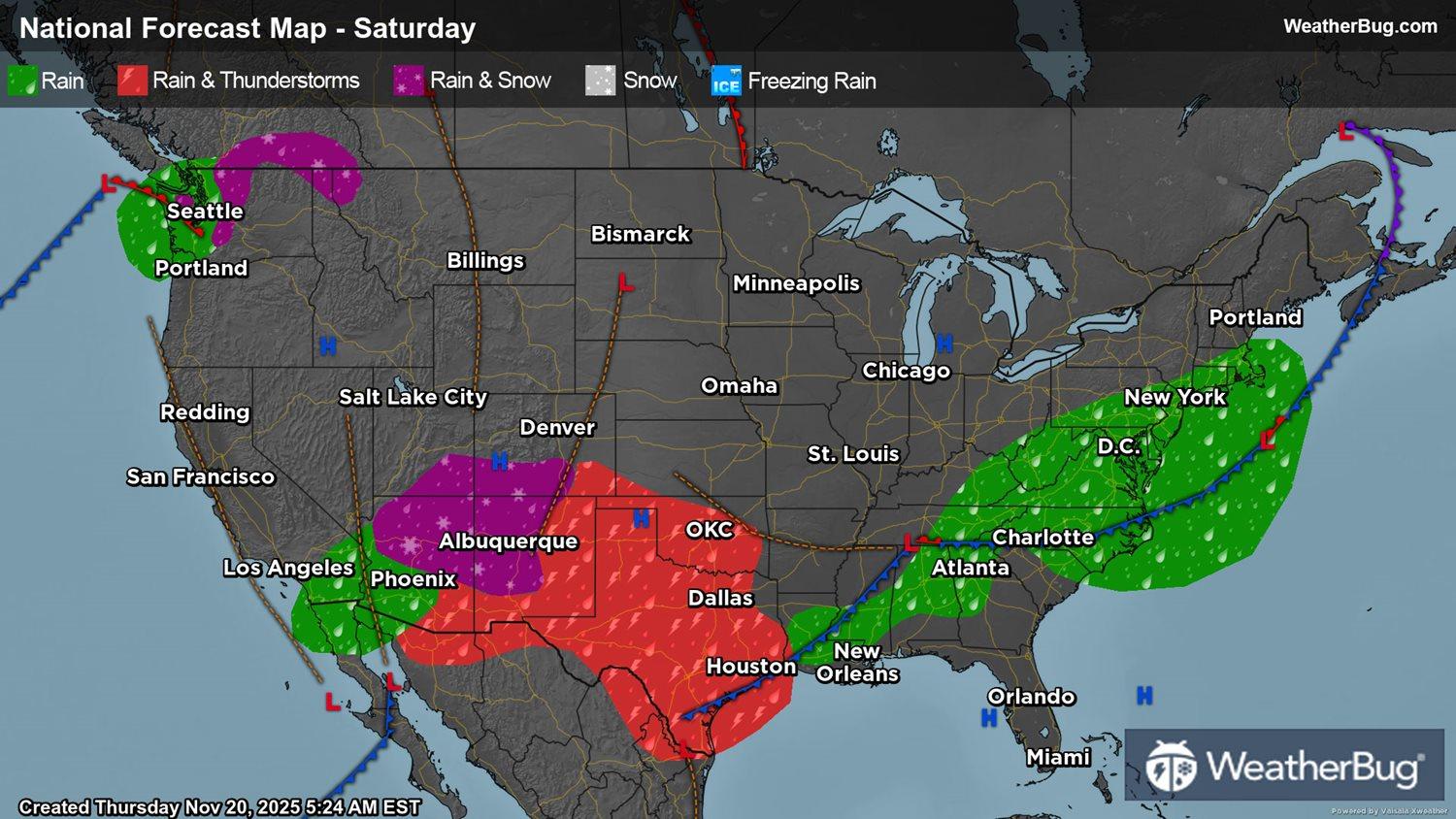
Saturday
An elongated cold front will be draped from the Mid-Atlantic and Southeast into the south-central U.S. on Saturday. Rain showers will soak the Mid-Atlantic throughout the day, with perhaps a few rain showers in the Tennessee and Mid-Mississippi valleys. Showers and thunderstorms will also be likely across the Southeast, Gulf Coast and southern Plains. Gusty winds could occur within these thunderstorms, mainly in the Southeast and the far southern Plains.
A second cold front will be advancing east across south-central Canada, which will clip the Great Lakes. Wet snow or a rain/snow will likely develop in the afternoon and evening. There could also be some light freezing rain or snow that mixes in at times.
Farther west, there will be a low pressure system that is “cut-off” from the normal weather flow. This will slowly drift from southern California into the Southwest for the start of the weekend. Most areas will see rain showers as a result, but the higher elevations of northern/eastern Arizona and western New Mexico could be cold enough for wet snow or rain/snow mix.
If that wasn’t enough, a large low pressure system will slowly be approaching the West Coast throughout Saturday. This will start to funnel some Pacific moisture into the Northwest. Moisture will generally be limited to western Washington, with rain becoming increasingly likely. The tallest peaks in the northern Cascades could also see some snow mixing in.
The rest of the Northwest, northern California and the Great Basin into the northern half of the Rockies and northern half of the Plains will be dry under high pressure. The Northeast will also be dry.
Temperatures will reach the 30s and 40s for the interior Northeast, Great Lakes and the higher elevations of the Mountain West. However, the tallest peaks could only see highs in the 20s! Fifties and 60s will be most common on Saturday, including the West Coast, California and Southwest into the northern and central Plains, Midwest, Ohio and Tennessee valleys, Mid-Atlantic and southern New England. Seventies and 80s are expected for the southern Plains, Gulf Coast and Southeast.
Sunday
The long cold front stretched across the southeastern and south-central U.S. will drift east and south on Sunday. It will gradually lose its moisture as it does this, but there could still be a few showers across the Florida Peninsula and far southern Texas.
The cold front clipping the Great Lakes on Saturday will also advance eastward. Precipitation will spread across the Northeast from west-to-east throughout the day. Snow will initially develop in the morning. Snow could then transition over to rain or a rain/snow mix for the lower elevations, while snow likely continues for the higher elevations. Any rain or wintry mix will change back over to snow late Sunday night.
The ”cut-off” low pressure system in the Southeast will eventually join back in the normal weather flow on Sunday, which will direct the low pressure into the High Plains. Rain will occur across Arizona, New Mexico, southern Utah and most of Colorado. However, temperatures will be cold enough for snow in the higher elevations of the Four Corner states.
Rain and thunderstorms will spread to the central and southern High Plains during the afternoon and evening. Strong to severe thunderstorms will be a possibility in the southern Plains in the afternoon and evening. The main threats would be damaging wind gusts and large hail, though an isolated, brief tornado cannot be ruled out.
Meanwhile, the large low pressure system in the Pacific will creep closer to the U.S. West Coast, continuing to funnel moisture into the Northwest. Expect rain throughout western and northern Washington as well as western Oregon for the entire day, with perhaps some showers developing later in the day for the rest of the Northwest. The tallest peaks in the Cascades will once again be cold enough for snow.
While there could be a few early showers in southern California, dry weather will generally prevail throughout California, the Great Basin, northern Plains, Midwest, Mid-Atlantic and much of the Southeast.
Sunday’s high temperatures will be almost identical to those on Saturday. Fifties and 60s will be found throughout most of the U.S. Expect 30s and 40s once again for the Northeast, Upper Great Lakes and much of the Mountain West. Seventies and 80s will cover the south-central and southeastern U.S.