Back to forecast
Weekend Weather Preview
December 14, 2023 at 03:17 PM EST
By WeatherBug Meteorologist, Alyssa Robinette
A soggy weekend is in store for the eastern half of the U.S. thanks to two troublesome storm systems. Elsewhere, quiet weather on Saturday will quickly be replaced by rain and snow on Sunday.
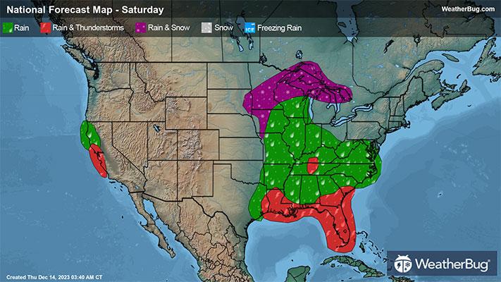
Saturday
An upper-level storm system will be moving from the north-central U.S. into the Mid-Mississippi Valley and Midwest on Saturday. The cold front associated with this weather system will also interact with a low pressure system in the Gulf of Mexico, which will pull it towards the Florida Peninsula. There will be a significant amount of moisture with both the weather system and the low pressure, but not a good amount of cold air.
Snow showers or a rain/snow mix will be found across the northern Plains, Upper Mississippi Valley and Upper Great Lakes in the morning, which will then change over to light rain or even end completely by midday. There could even be some light freezing rain that mixes in. Rain and maybe a thunderstorm or two will be likely across the rest of the Mississippi Valley, Deep South, Midwest and Florida in the morning.
Heavy to even very heavy rain will be likely across the Florida Peninsula during the afternoon and evening, while also becoming increasingly likely in the Southeast. Rain showers and a few thunderstorms will also continue for the Mississippi Valley, Midwest, Great Lakes and Deep South.
High pressure will build over the western half of the U.S. for the start of the weekend. This will foster dry and unseasonably mild weather. Settled weather will also be found in the Mid-Atlantic and Northeast.
The interior Northeast will be the coldest spot, with temperatures only reaching the teens and 20s. The highest elevations of the Rockies will also see highs in the 20s. Expect 30s, 40s and a few lower 50s for the rest of the Mountain West, the northern half of the Plains, Great Lakes, Midwest, Ohio Valley, southern New England and the Mid-Atlantic. The southern Plains, Deep South and Southeast will record 50s and 60s, with 60s and 70s in California, the Desert Southwest and Florida.
Sunday
The two storm systems from Saturday will merge into one large weather system on Sunday as it moves across the eastern U.S. The main batch of heavy to very heavy rain will be concentrated along the center of the low pressure system, which will slide from Florida into the Southeast throughout the day. Strong winds are possible in coastal areas of South Carolina and North Carolina.
Rain showers will continue to soak the Great Lakes, Ohio Valley, Midwest and Deep South in the morning. For the rest of the afternoon and evening, rain will become increasingly likely for Mid-Atlantic and Northeast, while also continuing in the Great Lakes and Ohio Valley.
There will be two new weather systems that impact the U.S. as well for the conclusion of the weekend. The first will drop south across the north-central U.S. late Sunday night. This could allow for a few snow showers in the northern Plains, Upper Mississippi Valley and Upper Great Lakes.
The other weather system will come crashing into the West Coast. Rain showers will begin across southwestern Oregon into northern and central California in the morning, then becoming likely for the afternoon and evening. There will also be some wet snowflakes flying in the Sierra Nevada.
Otherwise, high pressure will largely dominate the nation’s midsection. Expect dry weather for the Rockies and Southwest into the central and southern Plains and Lower Mississippi Valley as a result.
Most of the Rockies and the extreme northern Plains will have high temperatures in the teens and 20s. Most of the U.S. will experience 30s, 40s and the lower 50s, including the Northwest, Great Basin, the northern half of the Plains, Great Lakes, Midwest, Ohio and Tennessee valleys, Mid-Atlantic and Northeast. The far southern U.S. can expect 50s and 60s, with 70s for the Desert Southwest and Florida.