

Weekend Weather Preview
Saturday
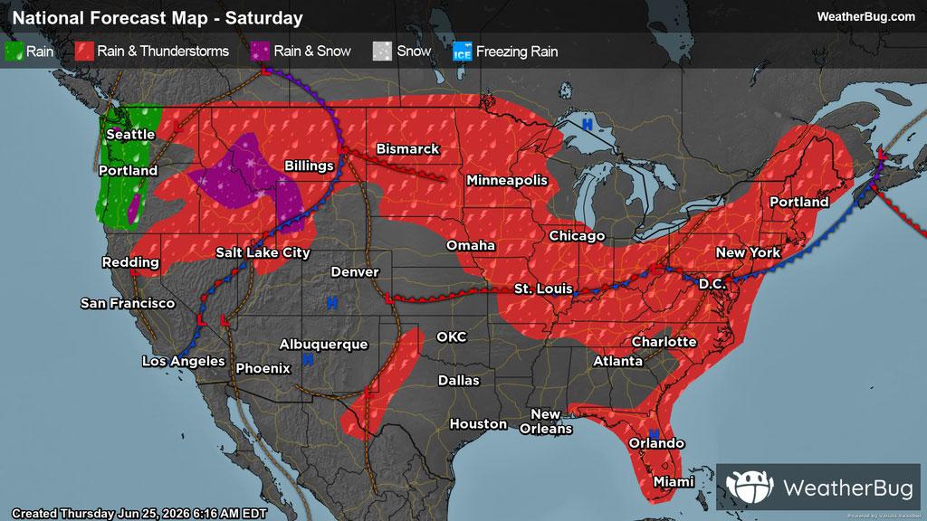
Multiple storm systems will continue to bring active weather to the East Coast, Lower Midwest, High Plains, Northern Mountain West, and the Pacific Northwest, along with western Texas. These regions can expect cloudy skies along with scattered showers and possible thunderstorms throughout the day.
Incredibly, the last weekend of June will feature a rain/snow mix across the tallest peaks of Idaho and Montana.
In the afternoon and evening hours, severe thunderstorms are possible in the High Plains and the Mid-Atlantic down through the Southeast.
Meanwhile, the rest of the country can anticipate for the most part to stay high and dry, perfect for National Sunglass Day.
Across the Northeast, much of the region can continue to anticipate high temperatures in the 60s and 70s. In the Mid-Atlantic down through the Southeast, highs are expected to be in the 80s and 90s. Meanwhile, much of the Midwest and Plains can anticipate high temperatures to be in the 70s and 80s.
Out West, there continues to be great variations in high temperatures, where the warmest readings will be in the Desert Southwest, western Texas, and the southwestern Plains, where highs may reach triple digits. However, In the Mountain West and the Pacific Northwest, temperatures will be unseasonably cool, with highs ranging from the 50s to the 70s. Areas of higher elevations can expect even cooler temperatures, dipping down into the 40s.
Sunday
Saturday’s weather disturbances will now shift eastward, bringing isolated showers and thunderstorms to the East Coast. Likewise, the Pacific Northwest, Northern Mountain West, High Plains, Upper Midwest along with western Texas will be prone to thunderstorms.
Similar to Saturday, the potential for some snow continues for the tallest peaks of the Rockies and Cascades.
Once again, storms will likely further develop starting in the afternoon, especially in the High Plains, where storms may be severe. For the most part, the rest of the U.S., will remain dry.
The Pacific Northwest and Mountain West will continue to see unseasonably cool temperatures with highs ranging from the 50s to the 70s. Areas of higher elevations can expect even cooler temperatures, dropping to the 40s. In the Desert Southwest, along with western Texas and much of the Plains, highs will be in the 90s, however some areas will surpass 100 degrees.
Much of the Eastern half of the country can also expect high temperatures in the 80s and 90s, however portions of New England, the Appalachian Mountains, along with the northernmost parts of the High Plains and Upper Midwest, anticipate temperatures to remain in the 70s.