Back to forecast
Snow Continues In The Rockies
February 9, 2024 at 05:23 PM EST
By WeatherBug Meteorologist, Rob Miller
Unsettled weather will continue throughout the West through the weekend as a series of upper-air disturbances produce additional snow in the mountains.
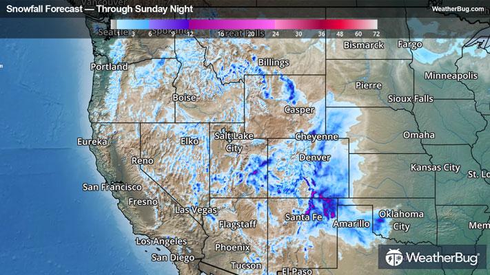
A large, slow-moving upper-level storm system will continue to crawl through the Western U.S. today through the weekend and will eventually emerge over the Plains by Monday. Moisture will be limited today into Saturday across the Great Basin and Rockies, with snow expected over the mountains.
Several inches of snow will fall over the mountains across eastern Oregon and Nevada eastward through western Montana and central and western Colorado, as well as northern New Mexico. Many locations above 7,500 feet will pick up 6 to 12 inches of fresh snow through tonight, while 2 to 6 inches of snow fall in some lower elevations.
On Saturday, snow will continue to fall across portions of Colorado, eastern Utah, Arizona, and New Mexico as an area of low pressure near the surface starts to develop. Snow totals of 2 to 6 inches will be common in the mountains, but locally 6 to 10 inches will be possible across portions of northeast New Mexico and southeast Colorado.
Snow will eventually spread into the High Plains Saturday evening and Sunday, with several inches of snow possible across portions of southwestern Kansas to northwestern Texas into early Monday.
Winter Weather Advisories remain in effect across portions of southern Montana, northern and southeast Wyoming, eastern Nevada, eastern Utah, southeastern Arizona, central New Mexico, eastern and western Colorado, and western Nebraska. Avalanche Warnings are also found across portions of eastern Idaho into southwestern Montana, as well as across the Wasatch Mountains of Utah.
Winter Storm Watches and Warnings have been issued on the High Plains of eastern Colorado, northeastern New Mexico, western Oklahoma, and the Texas panhandle.
Plan on slippery, snow road conditions leading to difficult to even impossible travel. Heavy to very heavy snowfall rates and blowing snow will cause low visibility. Downed trees and power lines are also a concern due to gusty winds. A large amount of new snow combined with windy conditions will lead to unstable snowpack, causing concerns for avalanches.
It’s never too early to have a supply kit packed in case of inclement weather. A simple kit including a weather radio, water, blankets, batteries, and non-perishable food items will go a long way in the event of a power outage. It’s always best to avoid travel in rough weather as the roads will be dangerous.