Severe Storms Rumble Toward Eastern Seaboard
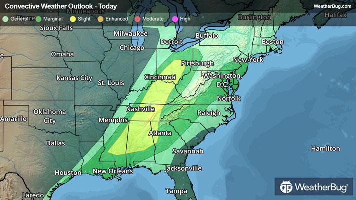
The remnants of a massive tornado outbreak continue to march across the Tennessee Valley and into the Southeast today, bringing thunderstorms and gusty winds along its path. Although the widespread tornado threat appears to have passed, damaging winds and an isolated twister are still possible.
Deep low pressure is spinning across the Great Lakes this morning, with a cold front stretching through the Ohio and Tennessee Valleys to the low’s south. This front separates warm and humid Gulf air ahead of the front from cold, Canadian air to its rear. These conditions were some of what led to a prolific tornado outbreak on Friday night.
Temperatures are expected to soar well into the 70s across the Southeast this afternoon, helping to fuel fresh thunderstorm development across Georgia and the interior Southeast. While the spin that helped to create tornadoes is now gone, gusty winds on the order of 60 to 70 mph and hail to the size of baseballs can still be expected this afternoon. Cities such as Atlanta, Asheville, N.C., and Montgomery, Ala., are at risk for these dangerous storms.
Meanwhile, storms of the less-thundery and more-gusty variety are likely to accompany the front’s passage across the Northeast and Mid-Atlantic. The warm air is surging northward, propelling temperatures as far north as Cleveland, Ohio, Buffalo, N.Y., and Washington, D.C., into the 60s.
Showers with embedded rumbles of thunder will rip across the region this afternoon, producing very strong winds. Unlike their thundery counterparts, the winds will continue well into the evening, with gusts of 45 to 70 mph likely across the Great Lakes, along the spine of the Appalachians and along and west of the Interstate 95 corridor from New England to the Mid-Atlantic.
High Wind Warnings are in place from central Michigan to Ohio, as well as much of western and northern New York, where the best chance for gusts of 50 to 70 mph exists. This includes Buffalo, N.Y., Detroit and Ann Arbor, Mich., and Cleveland, Ohio. A widespread risk of 40 to 60 mph gusts remains from Illinois to southern New England, as well as southward into the Mid-Atlantic and southern Appalachians and Tennessee Valley. Here, Wind Advisories are in place.
The winds will slowly diminish late this evening into early Sunday as the low exits into eastern Canada and is replaced by high pressure in the eastern U.S. This will usher cooler air into the region to end the weekend, but also much calmer conditions.
Already on Friday into today, long-track tornadoes, damaging winds and large hail were reported across a large swath of the Deep South, Mississippi Valley, Tennessee Valley and Ohio Valley. According to the government's Storm Prediction Center, one long-track supercell had a nearly continuous tornado debris signature for over three hours as it moved through Arkansas, Missouri, Tennessee and Kentucky. In addition, Nashville International Airport measured a peak wind gust of 78 mph earlier this morning, which is the third highest wind gust ever measured at the airport.