Back to forecast
Wind, Storm Surge Among Ida's Many Threats
August 30, 2021 at 04:12 AM EDT
UPDATED By WeatherBug Meteorologist, Andrew Rosenthal
Dangerous Category 4 Major Hurricane Ida is churning over northern the Gulf of Mexico, and its sights are clearly set on the central Gulf Coast for a landfall later today. Hurricane Warnings are in place for much of the Louisiana coast, with Storm Surge Warnings stretching from western Louisiana to Mississippi. What threats can be expected as Ida nears the coast?
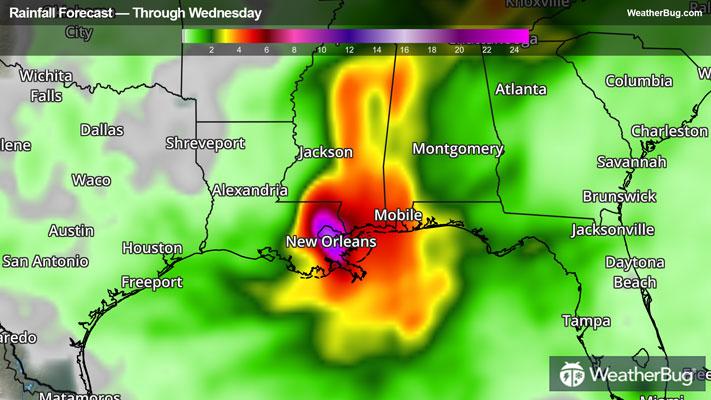
The rain will increase in intensity along and south of the Interstate 10 and 12 corridors in Louisiana this evening as it spreads northward into the Mississippi Valley. The heaviest downpours will come late today into Monday, where as much as 7 to 10 inches of rain will fall across the region on that day alone. By the time the rain finally winds down later Tuesday, totals from Ida will very likely be in the 10 to 15 inch range for New Orleans and Baton Rouge, with locally as much as 17 to 20 inches.
Drenching rainfall will follow Ida’s path into the Lower Mississippi Valley, with locales such as Jackson, Miss., and Memphis and Nashville, Tenn., poised to see 3 to 6 inches of rain through the middle of the work week. It goes without saying that this much rain will cause flooding, particularly in areas that have seen heavy rain in recent days and weeks.
2005’s Hurricane Katrina brought storm surges in excess of 10 feet, which ultimately overtopped the levees, flooding New Orleans. Ida’s storm surge won’t be quite this high in New Orleans, with waves of 4 to 8 feet above normal levels into Lake Pontchartrain and along the Mississippi and far-eastern Louisiana coast.
The highest surges will be right around where the storm moves ashore, potentially as high as 10 to 15 feet between Morgan City, La., and the mouth of the Mississippi River. Even as far west as southwestern Louisiana and as far east as the Alabama coast, a storm surge of 2 to 4 feet can be expected. These surges will produce high surf during the high tide cycles through this morning.
- Winds
- Rainfall
The rain will increase in intensity along and south of the Interstate 10 and 12 corridors in Louisiana this evening as it spreads northward into the Mississippi Valley. The heaviest downpours will come late today into Monday, where as much as 7 to 10 inches of rain will fall across the region on that day alone. By the time the rain finally winds down later Tuesday, totals from Ida will very likely be in the 10 to 15 inch range for New Orleans and Baton Rouge, with locally as much as 17 to 20 inches.
Drenching rainfall will follow Ida’s path into the Lower Mississippi Valley, with locales such as Jackson, Miss., and Memphis and Nashville, Tenn., poised to see 3 to 6 inches of rain through the middle of the work week. It goes without saying that this much rain will cause flooding, particularly in areas that have seen heavy rain in recent days and weeks.
- Storm Surge
2005’s Hurricane Katrina brought storm surges in excess of 10 feet, which ultimately overtopped the levees, flooding New Orleans. Ida’s storm surge won’t be quite this high in New Orleans, with waves of 4 to 8 feet above normal levels into Lake Pontchartrain and along the Mississippi and far-eastern Louisiana coast.
The highest surges will be right around where the storm moves ashore, potentially as high as 10 to 15 feet between Morgan City, La., and the mouth of the Mississippi River. Even as far west as southwestern Louisiana and as far east as the Alabama coast, a storm surge of 2 to 4 feet can be expected. These surges will produce high surf during the high tide cycles through this morning.
- Severe Weather