Back to forecast
Arctic Blast Hits Northeast, Mid-Atlantic
December 29, 2017 at 02:11 AM EST
UPDATED By WeatherBug Meteorologists, James West and Mark Ellinwood
An arctic blast is bringing big changes to large stretches of the northern and eastern Plains, Midwest, Great Lakes and the Northeast. Winter weather gear will be needed this weekend.
Autumn started off relatively mild east of the Rockies, with most of the arctic air remaining bottled up in Canada’s Polar Regions. However, an arctic blast spreading across the Midwest, Great Lakes, Northeast and Mid-Atlantic is producing the season’s first winter blast.
Crank the heater and make good use of the fireplace. Morning lows are in the single digits and teens in Upstate New York, with teens also found from northern Pennsylvania to Maine. Breezy wind conditions in the Northeast will make for wind chills near or below zero. The afternoon highs will be a tad warmer, but only in the 20s.
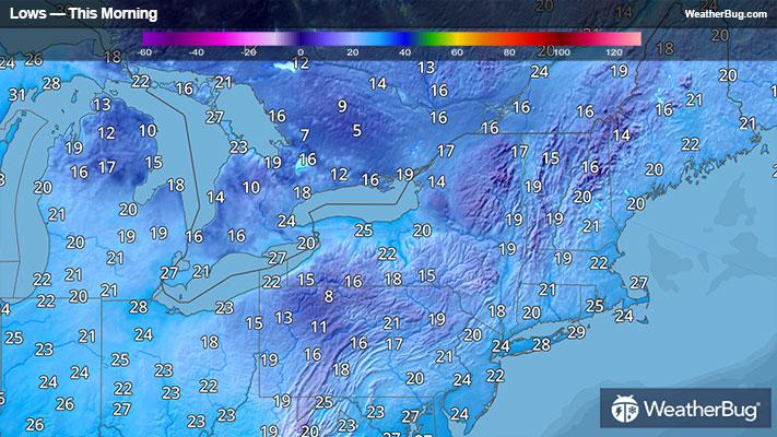
This morning is the coldest of the weekend for most of the Mid-Atlantic and I-95 corridor. Low temperatures well into to the 20s can be found from Baltimore to Boston, with freezing temperatures found as far south as central North Carolina westward into the Tennessee and lower Ohio valleys. This will be sure to kill any summer plants that have survived through the mild weather that has been experienced so far. High temperatures will warm up into the upper 30s under mostly sunny skies this afternoon.
Records low have been widespread this morning across the Mid-Atlantic and Northeast. Pittsburgh fell to 17 degrees, breaking the previous record of 21 degrees. Meanwhile, Washington D.C, Baltimore Airport, Laguardia and Boston all saw record lows as well.
Freeze Warnings are in effect from northern South Carolina to the Delaware Valley. This includes Richmond, Va., Washington, D.C., Baltimore, Wilmington, Del., and Philadelphia.
Bitter cold also persists across the northern Plains, northern Mississippi Valley, Midwest, and Great Lakes. Lows in these areas reach into the teens, with 20s found as far south as the Ohio Valley.
There will be a return to more normal temperatures for this time of year by Sunday and Monday. As the high-pressure system moves off the Atlantic coast, it will usher in milder temperatures with a southerly wind. Temperatures will still be on the cool side, but not arctic cold, making this winter preview a brief one.
Autumn started off relatively mild east of the Rockies, with most of the arctic air remaining bottled up in Canada’s Polar Regions. However, an arctic blast spreading across the Midwest, Great Lakes, Northeast and Mid-Atlantic is producing the season’s first winter blast.
Crank the heater and make good use of the fireplace. Morning lows are in the single digits and teens in Upstate New York, with teens also found from northern Pennsylvania to Maine. Breezy wind conditions in the Northeast will make for wind chills near or below zero. The afternoon highs will be a tad warmer, but only in the 20s.
This morning is the coldest of the weekend for most of the Mid-Atlantic and I-95 corridor. Low temperatures well into to the 20s can be found from Baltimore to Boston, with freezing temperatures found as far south as central North Carolina westward into the Tennessee and lower Ohio valleys. This will be sure to kill any summer plants that have survived through the mild weather that has been experienced so far. High temperatures will warm up into the upper 30s under mostly sunny skies this afternoon.
Records low have been widespread this morning across the Mid-Atlantic and Northeast. Pittsburgh fell to 17 degrees, breaking the previous record of 21 degrees. Meanwhile, Washington D.C, Baltimore Airport, Laguardia and Boston all saw record lows as well.
Freeze Warnings are in effect from northern South Carolina to the Delaware Valley. This includes Richmond, Va., Washington, D.C., Baltimore, Wilmington, Del., and Philadelphia.
Bitter cold also persists across the northern Plains, northern Mississippi Valley, Midwest, and Great Lakes. Lows in these areas reach into the teens, with 20s found as far south as the Ohio Valley.
There will be a return to more normal temperatures for this time of year by Sunday and Monday. As the high-pressure system moves off the Atlantic coast, it will usher in milder temperatures with a southerly wind. Temperatures will still be on the cool side, but not arctic cold, making this winter preview a brief one.