Back to forecast
Winter Storm Sweeps Across Great Lakes, Northern Plains
December 30, 2019 at 08:54 PM EST
By WeatherBug Meteorologist, Brian Dillon
The final days of 2019 are coming to an end, but Old Man Winter is still in control across the Dakotas and upper Great Lakes. A deepening storm system over Lake Superior will bring plenty of snow, ice, and breezy conditions as it pushes east into Ontario.
This complex system will bring a plethora of different weather to the Great Lakes and the Dakotas throughout today. As colder air from the Canadian Prairies gets drawn south into the northern Plains, bands of moderate to heavy snow will increase across the region. Rain across Michigan will transition to snow later tonight into Tuesday as colder air filters south across the Mitten state. North to northwesterly winds up to 35 to 45 mph will produce blowing and drifting snow across the Dakotas, Minnesota, Wisconsin, and upper Michigan later this afternoon and evening.
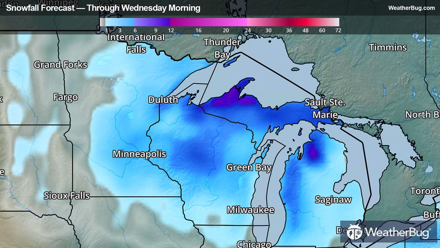
Across the the north-central U.S., Winter Storm Warnings and Winter Weather Advisories remain in effect for portions of the eastern Dakotas, northern Nebraska, Minnesota, northern Iowa, Wisconsin, northern and western Michigan and extreme portions of northwest Indiana. Total snowfall accumulations of 3 to 6 inches are expected mainly west of Lake Michigan for cities like Sioux Falls, S.D., Fargo, N.D., Minneapolis, Duluth and Green Bay, Wis.
However, as the storm gathers strength, snowfall accumulations will be much higher northern and western Michigan. With colder air traveling across warmer waters of the Great Lakes, enhanced areas of lake-effect snow will add to the snow depths across the region. Locally heavier snow amounts of 4 to 12 inches are likely from South Bend, Ind., Grand Rapids, Muskegon, and Petoskey, Mich. The heaviest snow amounts will be across the Upper Peninsula of Michigan, including the cities of Sault Ste. Marie and Marquette, with localized amounts of 12 to 18 inches possible by Tuesday afternoon.
As is always the case, if you need to do any traveling in wintry weather, be sure to pack a cold and snow survival kit. Your kit should include batteries, flashlights, extra food, extra warm clothes, gloves, hats, and a shovel.
This complex system will bring a plethora of different weather to the Great Lakes and the Dakotas throughout today. As colder air from the Canadian Prairies gets drawn south into the northern Plains, bands of moderate to heavy snow will increase across the region. Rain across Michigan will transition to snow later tonight into Tuesday as colder air filters south across the Mitten state. North to northwesterly winds up to 35 to 45 mph will produce blowing and drifting snow across the Dakotas, Minnesota, Wisconsin, and upper Michigan later this afternoon and evening.
Across the the north-central U.S., Winter Storm Warnings and Winter Weather Advisories remain in effect for portions of the eastern Dakotas, northern Nebraska, Minnesota, northern Iowa, Wisconsin, northern and western Michigan and extreme portions of northwest Indiana. Total snowfall accumulations of 3 to 6 inches are expected mainly west of Lake Michigan for cities like Sioux Falls, S.D., Fargo, N.D., Minneapolis, Duluth and Green Bay, Wis.
However, as the storm gathers strength, snowfall accumulations will be much higher northern and western Michigan. With colder air traveling across warmer waters of the Great Lakes, enhanced areas of lake-effect snow will add to the snow depths across the region. Locally heavier snow amounts of 4 to 12 inches are likely from South Bend, Ind., Grand Rapids, Muskegon, and Petoskey, Mich. The heaviest snow amounts will be across the Upper Peninsula of Michigan, including the cities of Sault Ste. Marie and Marquette, with localized amounts of 12 to 18 inches possible by Tuesday afternoon.
As is always the case, if you need to do any traveling in wintry weather, be sure to pack a cold and snow survival kit. Your kit should include batteries, flashlights, extra food, extra warm clothes, gloves, hats, and a shovel.