Back to forecast
Blizzard Winds Down In The Northern Plains
October 12, 2019 at 07:28 AM EDT
UPDATED By WeatherBug Meteorologist, Mark Ellinwood
The heavy snow and strong winds will slowly subside throughout the day today, but not before several more inches of snowfall in places that have already seen 1 to 2 feet of the white stuff.
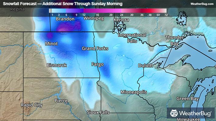
Blizzard Warnings, Winter Storm Warnings and Winter Weather Advisories remain in place across the central and eastern Dakotas and northwestern Minnesota. Another 2 to 5 inches of snow will likely fall in these areas, with locally higher amounts of 6 to 12 inches in north-central North Dakota. Gusty winds will continue to whip the snow around in the air today, creating whiteout conditions at times.
Temperatures were cold enough this morning to end the growing season across much of the Plains with widespread 20s to lower 30s from Wisconsin to north Texas where Freeze Warnings are in effect. This includes Wichita Falls, Texas, Oklahoma City, Kansas City, Mo., Des Moines, Iowa, Peoria, Ill., and Milwaukee and Green Bay.
Milder weather returns to the Mid-Mississippi Valley, central and southern Plains this weekend with temperatures staying above freezing tonight to Sunday morning and once again Sunday night into Monday morning. Further to the north, overnight lows tonight and Sunday night will be dangerously close to freezing across the Upper Midwest and Great Lakes as the slow-moving low pressure continues to push a Canadian air mass south into these locales.
The latest winter storm is being measured in feet. Langdon, N.D., leads the pack with 27 inches of snow followed by Harvey, N.D., with 24 inches. Bismarck, N.D., tallied 13.2 inches, with at least 6.1 inches falling on Friday alone. This shatters the former daily snow record for October 11 by more than 4 inches! Rapid City, S.D., has seen 14.3 inches of snow with Pierre, S.D., measuring 8 inches.
Traveling in heavy snow is only safe when being well-prepared. Check the chain rules if traveling in the mountains. It is also good to keep a snow emergency kit in your vehicle. This should consist of blankets, water, non-perishable food, jumper cables, mittens, a flashlight as well as an extra cell phone charger. If you don’t have to travel, it is best to stay indoors by the fireside.