10-Day Weather Forecast - Groton, SD
Weekend Weather
- |69°F
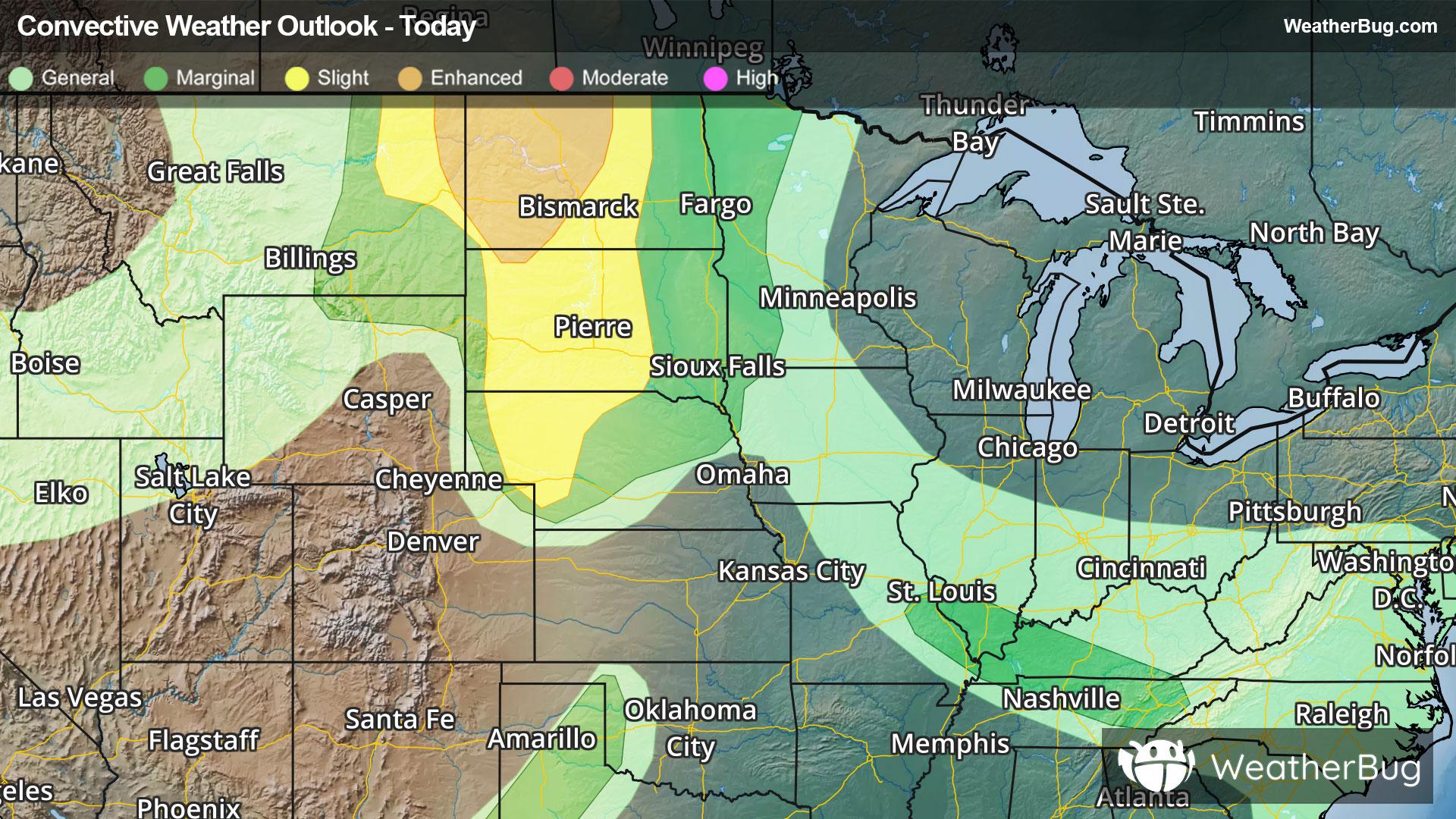
 ThunderstormsHourly details
Tonight
69°FCloudy. A slight chance of thunderstorms late this evening then showers with a chance of thunderstorms. Locally heavy rainfall possible. Lows in the upper 60s. Southeast winds 15 to 20 mph with gusts up to 35 mph. Chance of rain 90 percent.
- 83|72°F
 50% Chance of StormsHourly details
Day
83°FMostly cloudy with a chance of thunderstorms in the morning then partly sunny with a slight chance of thunderstorms in the afternoon. Humid with highs in the upper 80s. Southeast winds 10 to 15 mph with gusts up to 30 mph. Chance of rain 50 percent.
Night
72°F
Mostly clear in the evening then becoming partly cloudy. Humid with lows in the mid 60s. East winds 5 to 10 mph.
- 88|65°F50% Chance of StormsHourly details
Day
88°FA chance of showers in the morning. Partly sunny with a slight chance of thunderstorms. Humid with highs in the upper 80s. Southeast winds 10 to 15 mph becoming southwest 15 to 20 mph in the afternoon. Chance of rain 50 percent.
Night
65°F
Mostly clear. Lows in the lower 60s. Southwest winds 15 to 20 mph with gusts up to 30 mph diminishing to around 10 mph with gusts up to 20 mph after midnight.
- 88|64°F
 Mostly SunnyHourly details
Day
88°FMostly sunny. Highs in the upper 80s.
Night
64°FClear in the evening then becoming partly cloudy. A 20 percent chance of thunderstorms. Lows in the lower 60s.
- 90|66°F40% Chance of StormsHourly details
Day
90°FPartly sunny. A chance of thunderstorms in the afternoon. Hot with highs around 90. Chance of rain 40 percent.
Night
66°FPartly cloudy with a chance of showers with a slight chance of thunderstorms in the evening then mostly cloudy with a slight chance of showers after midnight. Lows in the mid 60s. Chance of rain 40 percent.
- 91|66°FMostly SunnyHourly details
Day
91°FPartly sunny. A slight chance of thunderstorms in the afternoon. Hot with highs in the lower 90s. Chance of rain 20 percent.
Night
66°FShowers likely with a chance of thunderstorms in the evening then a slight chance of thunderstorms after midnight. Lows in the mid 60s. Chance of rain 60 percent.
- 93|75°F
 Partly CloudyHourly details
Day
93°FPartly sunny. Hot with highs in the mid 90s.
Night
75°FMostly clear in the evening then becoming partly cloudy. A 40 percent chance of thunderstorms. Lows around 70.
Weekend Weather
- 94|68°F30% Chance of Storms
Day
94°FPartly sunny with a slight chance of thunderstorms. A chance of showers in the afternoon. Hot with highs in the mid 90s. Chance of rain 30 percent.
Night
68°F
Mostly clear with a 50% chance for rain and thunderstorms. Low temperature around 68F. Dew point will be around 66F with an average humidity of 69%. Winds will be 2 mph from the SE.
- 87|66°F
 Sunny
SunnyDay
87°FSunny. High temperature around 87F. Dew point will be around 64F with an average humidity of 59%. Winds will be 2 mph from the E.
Night
66°FClear with a slight chance of rain. Chance of precipitation 25%. Low temperature around 66F. Dew point will be around 63F with an average humidity of 69%. Winds will be 2 mph from the E.
- 89|65°FSunny
Day
89°FSunny. High temperature around 89F. Dew point will be around 63F with an average humidity of 56%. Winds will be 2 mph from the SE.
Night
65°FClear with a slight chance of rain. Chance of precipitation 25%. Low temperature around 65F. Dew point will be around 62F with an average humidity of 66%. Winds will be 3 mph from the SE.