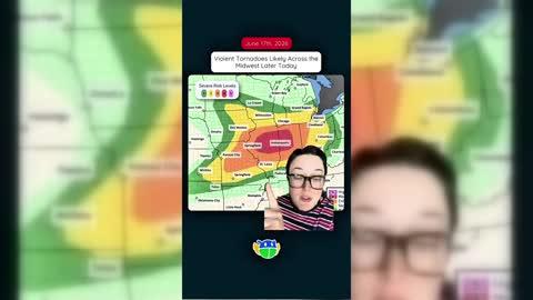
Chatillon, Aosta Valley, IT

Weather

As of
Current Temperature
59
Feels like:59°
Today's high temperature
--
Today's low temperature
59°

30% Chance Rain Showers

Live Weather Radar

Chatillon, Aosta Valley, IT weather radar map

Current Weather Details

Windchill
88°
Daily Rain
--"
Dew point
64°
Monthly Rain
--"
Humidity
48%
Avg. Wind
ESE 4 mph
Pressure
--"
Wind Gust
-- mph
Sunrise
5:39 AM
Moon
Waxing Crescent
Sunset
9:21 PM
UV Index
9 (Very High)

Weather Forecast

  • Tonight

    Lo

    Mostly clear with a 35% chance for rain and thunderstorms. Low temperature around 69F. Dew point will be around 53F with an average humidity of 58%. Winds will be 3 mph from the N.

  • Tomorrow

    Hi

    Sunny with a 40% chance for rain and thunderstorms. High temperature around 90F. Dew point will be around 57F with an average humidity of 55%. Winds will be 4 mph from the SE.

Chatillon, Aosta Valley, IT 10-day weather forecast

AIR QUALITY

Air Quality Index
32|Fair
Top Triggers:
pm25
View Today's Air Quality details for Chatillon, Aosta Valley, IT

POLLEN COUNT & ALLERGY FORECAST

Pollen Count
--|Not Available
Predominant Pollen:
Chatillon, Aosta Valley, IT Pollen forecast details

LIGHTNING MAP

Closest strike in the last 30 minutes:618.7 miles

No Lightning Nearby

Chatillon, Aosta Valley, IT real-time lightning alerts & live Map