
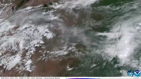
Dangerous Storms Near High Plains, Ohio Valley, New England
Several disturbances will trigger severe thunderstorms today across the U.S.
Read More
73degrees Fahrenheit

Feels like:73°
Hi:79°Lo:69°
70% Chance Rain Showers
Lo

Showers likely with a chance of thunderstorms. Some thunderstorms may produce heavy rainfall. Near steady temperature in the lower 70s. Southwest winds 5 to 10 mph. Chance of rain 70 percent.
Hi

Partly sunny with a chance of thunderstorms. Showers likely mainly in the morning. Some thunderstorms may produce heavy rainfall. Highs in the mid 80s. Southwest winds around 5 mph. Chance of rain 70 percent.

Closest strike in the last 30 minutes:134.8 miles
No Lightning Nearby


