
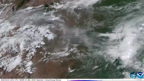
Dangerous Storms Near High, Southern Plains
Several disturbances will trigger severe thunderstorms today across the U.S.
Read More
69degrees Fahrenheit

Feels like:69°
Hi:77°Lo:67°
Mostly Cloudy
Lo

Mostly cloudy. Lows in the mid 60s. East winds 5 to 10 mph.
Hi

Patchy fog in the morning. Mostly cloudy in the morning then partly sunny with a chance of showers with a slight chance of thunderstorms in the afternoon. Humid with highs in the mid 80s. Southeast winds 10 to 15 mph with gusts up to 25 mph. Chance of rain 20 percent.

Closest strike in the last 30 minutes:253.0 miles
No Lightning Nearby


