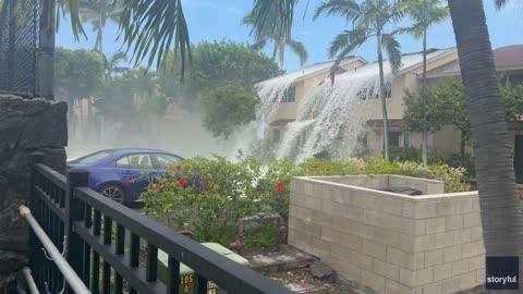
Kettwig, Nordrhein-Westfalen, DE

Weather

As of
Current Temperature

88degrees Fahrenheit

Feels like:89°

Hi:92°Lo:63°

Partly Cloudy

Live Weather Radar

Kettwig, Nordrhein-Westfalen, DE weather radar map

Current Weather Details

Windchill
89°
Daily Rain
0"
Dew point
64°
Monthly Rain
--"
Humidity
46%
Avg. Wind
N 9 mph
Pressure
30.21" →
Wind Gust
9 mph
Sunrise
5:15 AM
Moon
Waxing Gibbous
Sunset
9:52 PM
UV Index
8 (Very High)

Weather Forecast

  • Today

    Hi

    Mostly sunny. High temperature around 92F. Dew point will be around 65F with an average humidity of 70%. Winds will be 7 mph from the NE.

  • Tonight

    Lo

    Mostly clear. Low temperature around 63F. Dew point will be around 60F with an average humidity of 64%. Winds will be 7 mph from the NE.

Kettwig, Nordrhein-Westfalen, DE 10-day weather forecast

AIR QUALITY

Air Quality Index
41|Moderate
Top Triggers:
o3
View Today's Air Quality details for Kettwig, Nordrhein-Westfalen, DE

POLLEN COUNT & ALLERGY FORECAST

Pollen Count
--|Not Available
Predominant Pollen:
Kettwig, Nordrhein-Westfalen, DE Pollen forecast details

LIGHTNING MAP

Closest strike in the last 30 minutes:193.9 miles

No Lightning Nearby

Kettwig, Nordrhein-Westfalen, DE real-time lightning alerts & live Map