
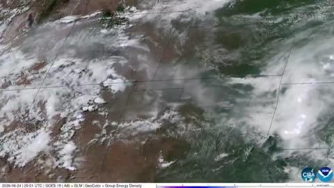
Storms Bring Flood & Severe Risk from the High Plains to the Carolinas
Two low pressure systems will bring severe weather conditions to the High Plains and Carolinas today.
Read More
59degrees Fahrenheit

Feels like:59°
Hi:63°Lo:59°
Partly Cloudy
Lo

Partly cloudy. Low temperature around 62F. Dew point will be around 59F with an average humidity of 82%. Winds will be 19 mph from the SE.
Hi

Partly cloudy this morning then mostly sunny with a chance of showers and thunderstorms this afternoon. Some thunderstorms may be severe. Highs in the upper 80s. South winds 10 to 20 mph with gusts up to 35 mph. Chance of rain 50 percent.

Closest strike in the last 30 minutes:158.6 miles
No Lightning Nearby


