
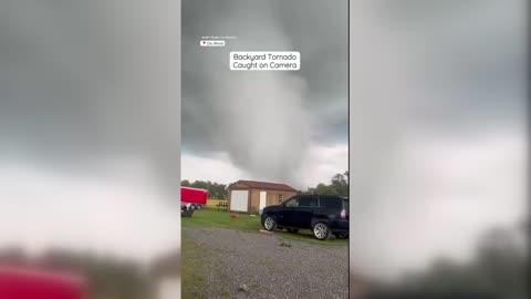
Thunderstorms to Rumble Across the Plains, Atlantic Coast
There are a pair of areas to watch in terms of severe thunderstorms today
Read More
65degrees Fahrenheit

Feels like:65°
Hi:67°Lo:53°
40% Chance Rain Showers
Hi

Partly cloudy with likely rain. Chance of precipitation 100%. High temperature around 67F. Dew point will be around 53F with an average humidity of 65%. Winds will be 5 mph from the SE.
Lo

Mostly cloudy. Showers with a chance of thunderstorms this evening then a chance of showers with a slight chance of thunderstorms after midnight. Lows around 50. South winds 5 to 10 mph. Chance of rain 80 percent.

Closest strike in the last 30 minutes:58.0 miles
No Lightning Nearby


