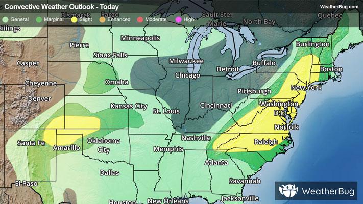
Shelbyville, KY Weather

As of

Weather Station:Lake Forest Country Club

Open weather station selector modal

72degrees Fahrenheit

Feels like:72°F

Hi: 72Lo: 36

50% Chance Rain Showers

Live Weather Radar

Shelbyville, KY weather radar map

Current Weather Details

Windchill
72°
Daily Rain
0.04"
Dew point
66°
Monthly Rain
2.63"
Humidity
82%
Avg. Wind
SW 0 mph
Pressure
29.74" →
Wind Gust
N 0 mph
Sunrise
7:58 AM
Moon
Third Quarter
Sunset
7:44 PM
UV Index
5 (Moderate)

Weather Forecast

  • Today

    Hi

    Breezy. Chance of thunderstorms in the morning then showers likely and chance of thunderstorms in the afternoon. Some thunderstorms may be severe with damaging winds large hail and tornadoes in the morning. Highs in the mid 70s. Southwest winds 15 to 25 mph. Chance of precipitation 70 percent.

  • Tonight

    Lo

    Breezy. Much colder. Mostly cloudy. A 50 percent chance of thunderstorms in the evening. Lows in the lower 30s. Northwest winds 10 to 25 mph.

Shelbyville, KY 10-day weather forecast

AIR QUALITY

28 | Fair

Top Triggers:pm25
Air quality data provided by Ambee
View Today's Air Quality details for Shelbyville, KY

POLLEN COUNT & ALLERGY FORECAST

2.3 Low

Predominant Pollen:Cedar/Juniper and Elm
View the Pollen forecast details

LIGHTNING MAP

Closest strike in the last 30 minutes:182.9 miles

No Lightning Nearby

Real-time lightning alerts & live Map