
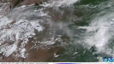
Dangerous Storms Near High, Southern Plains
Several disturbances will trigger severe thunderstorms today across the U.S.
Read More
72degrees Fahrenheit

Feels like:72°
Hi:81°Lo:72°
40% Chance of Light Rain
Lo

Showers likely early in the evening. Chance of thunderstorms through the night. Showers likely late in the night. Some thunderstorms may produce heavy rainfall after midnight. Lows in the upper 60s. South winds 5 to 10 mph. Chance of precipitation 70 percent.
Hi

Showers likely and chance of thunderstorms in the morning then chance of thunderstorms in the afternoon. Some thunderstorms may produce heavy rainfall. Highs in the lower 80s. Southwest winds 5 to 15 mph. Chance of precipitation 70 percent.

Closest strike in the last 30 minutes:500.5 miles
No Lightning Nearby


