
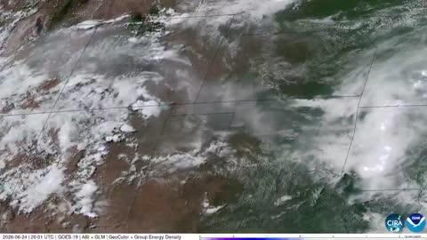
Dangerous Storms Expected Near Front Range, Ohio Valley, New England
Several disturbances will trigger severe thunderstorms today across the U.S.
Read More
60degrees Fahrenheit

Feels like:60°
Hi:60°Lo:49°
40% Chance Rain Showers
Hi

Mostly cloudy with likely rain. Chance of precipitation 90%. High temperature around 60F. Dew point will be around 48F with an average humidity of 77%. Winds will be 3 mph from the N.
Lo

Rain showers and a chance of thunderstorms in the evening then rain showers overnight. Lows in the mid 30s to mid 40s. Gusts up to 20 mph overnight. Chance of precipitation near 100 percent. Rainfall amounts up to a half of an inch possible except higher amounts possible in thunderstorms.

Closest strike in the last 30 minutes:63.3 miles
No Lightning Nearby


