

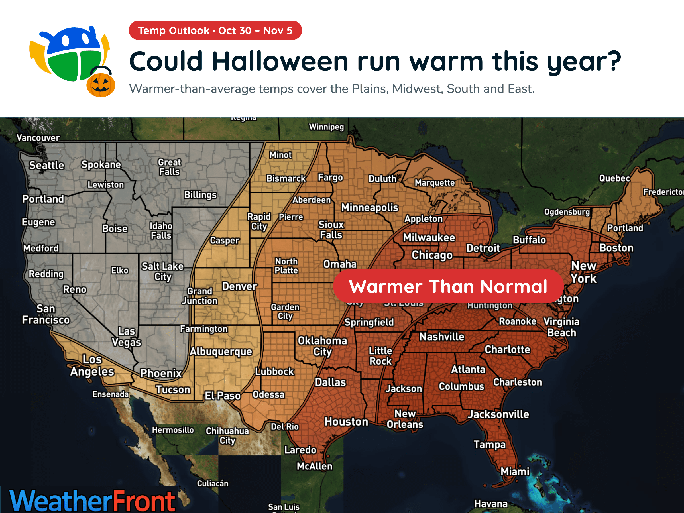
Halloween Weather Outlook: A Warm-Up for Much of the U.S. 🎃
Warmer-than-average temperatures could stick around into early November, but will you need a jacket over your Halloween costume?
Read More
# HEADLINE -------------------- FLOOD WATCH IN EFFECT FROM 6 AM MDT SATURDAY THROUGH LATE SATURDAY NIGHT # DETAILS -------------------- WHAT Flash flooding caused by excessive rainfall continues to be possible. WHERE Portions of central, east central, north central, northeast, and southeast New Mexico, including the following areas, in central New Mexico, Central Highlands, Eastern Lincoln County, Estancia Valley, Middle Rio Grande Valley including the Albuquerque Metro Area, Sandia and Manzano Mountains including Edgewood and South Central Highlands. In east central New Mexico, De Baca County and Guadalupe County. In north central New Mexico, Sangre de Cristo Mountains, Espanola Valley, Far Northwest Highlands, Glorieta Mesa Including Glorieta Pass, Jemez Mountains, Northwest Highlands, Santa Fe Metro Area, Tusas Mountains Including Chama and Upper Rio Grande Valley. In northeast New Mexico, Eastern San Miguel County, Far Northeast Highlands, Johnson and Bartlett Mesas Including Raton Pass and Northeast Highlands. In southeast New Mexico, Chaves County Plains and Southwest Chaves County. WHEN From 6 AM MDT Saturday through late Saturday night. IMPACTS Excessive runoff may result in flooding of rivers, creeks, streams, and other low-lying and flood-prone locations. Creeks and streams may rise out of their banks. Flooding may occur in poor drainage and urban areas. Low-water crossings may be flooded. ADDITIONAL DETAILS - Showers and thunderstorms will redevelop early Saturday and expand in coverage though the afternoon. Rainfall rates in excess of 1 inch per hour may cause flash flooding on already saturated soils. Arroyos, small streams and channels may quickly rise with water from heavy rainfall. Repeated rounds of storms will increase the risk for flash flooding. - http://www.weather.gov/abq/EmergencyPrepFlood ISSUED AT Friday, October 23, 2026 at 10:45 PM MDT ISSUED BY National Weather Service Albuquerque NM HEADER URGENT - IMMEDIATE BROADCAST REQUESTED | Flood Watch # PRECAUTIONARY/PREPAREDNESS ACTIONS -------------------- You should monitor later forecasts and be prepared to take action should Flash Flood Warnings be issued. # AREAS AFFECTED -------------------- Far Northwest Highlands, Northwest Highlands, Tusas Mountains Including Chama-Jemez Mountains-Glorieta Mesa
Closest strike: 7.79 miles Stay Alert! Remain in a safe area until there has been no lightning within 10 miles of this location for 30 minutes. Please be aware that lightning activity can remain high even when a storm is moving away from your location. Even if rain has stopped, do not leave your safe area until WeatherBug indicates that lightning is more than 10 miles away from this selected location. IF OUTDOORS Avoid water, high ground, and open spaces. Avoid all metal objects including electric wires, fences, and machinery. Find a safe area in a building or in a fully enclosed vehicle with the windows completely shut. Unsafe places include underneath canopies, small picnic or rain shelters, convertibles, or near trees. IF INDOORS Avoid water and stay away from doors and windows. Avoid using a hard line telephone. Take off headphones. Turn off, unplug, and stay away from appliances, computers, power tools, and TV sets. Lightning may strike exterior electric and phone lines, inducing shocks to inside equipment.
There is a Marginal Severe Storm Risk for your location. Continue reading for today's outlook from the National Weather Service's Storm Prediction Center. -------------------- National Severe Storm Outlook THERE IS A SLIGHT RISK OF SEVERE THUNDERSTORMS THIS AFTERNOON AND EVENING OVER PARTS OF NEW MEXICO AND FAR WEST TX SUMMARY Severe wind/hail and a tornado are possible across portions of New Mexico and far west Texas today. NM/Far West TX Morning water vapor imagery shows an upper low over southwest AZ, and a pronounced shortwave trough in the southeast quadrant of the low over northern Mexico. This feature will rotate northeastward today across southern New Mexico and West TX, aiding in the development of strong/severe storms. Present indications are that scattered thunderstorms will occur through the day over central/northern NM in advance of the approaching upper trough. Relatively cool air aloft and pockets of daytime heating may result in sufficient destabilization for a risk of a few strong/severe storms capable of hail. This activity will spread northeastward into a progressively less favorable air mass for severe storms by early evening. Farther south, more abundant sun/heating is expected with temperatures warming into the 80s over southern NM and the Trans Pecos region of TX. Scattered afternoon thunderstorm development is expected - mainly after 18z. Strengthening southeasterly low-level winds and favorable deep-layer shear will be favorable for supercell storm structures capable of large hail and gusty/damaging winds. Forecast hodographs also suggest sufficient low-level shear for a tornado or two if discrete storm mode can be maintained. It appears the main risk will weaken after 01z with the onset of nocturnal cooling.
Warmer-than-average temperatures could stick around into early November, but will you need a jacket over your Halloween costume?







