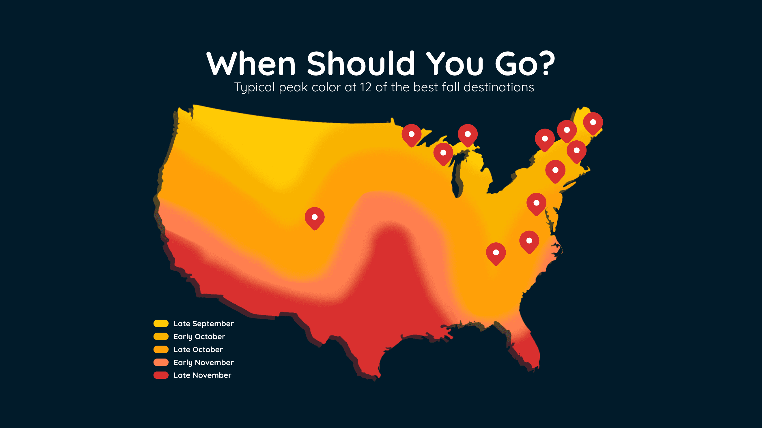
When Fall Colors Peak at 12 Top US Destinations
Find the best time to see peak fall colors at 12 popular U.S. destinations, including New England, the Smokies, Michigan and Colorado.
Read More
# SUMMARY -------------------- THE NATIONAL WEATHER SERVICE HAS ISSUED TORNADO WATCH 669 IN EFFECT UNTIL MIDNIGHT CDT TONIGHT FOR THE FOLLOWING AREAS IN IOWA THIS WATCH INCLUDES 17 COUNTIES IN CENTRAL IOWA BOONE DALLAS POLK IN SOUTH CENTRAL IOWA CLARKE MADISON RINGGOLD UNION WARREN IN SOUTHWEST IOWA ADAIR ADAMS CASS TAYLOR IN WEST CENTRAL IOWA AUDUBON CARROLL CRAWFORD GREENE GUTHRIE THIS INCLUDES THE CITIES OF ADAIR, ADEL, ATLANTIC, AUDUBON, BAYARD, BEDFORD, BOONE, CARLISLE, CARROLL, CASEY, CORNING, CRESTON, DENISON, DES MOINES, EARLHAM, EXIRA, FONTANELLE, GREENFIELD, GUTHRIE CENTER, INDIANOLA, JEFFERSON, LENOX, MOUNT AYR, NEW MARKET, NORWALK, OSCEOLA, PANORA, PERRY, STUART, WAUKEE, AND WINTERSET. # DETAILS -------------------- PRIMARY THREATS INCLUDE - A COUPLE TORNADOES POSSIBLE. SCATTERED DAMAGING WINDS AND ISOLATED SIGNIFICANT GUSTS TO 80 MPH LIKELY. SCATTERED LARGE HAIL AND ISOLATED VERY LARGE HAIL EVENTS TO 2 INCHES IN DIAMETER POSSIBLE. - PROBABILITY TABLE: PROB OF 2 OR MORE TORNADOES : 40% PROB OF 1 OR MORE STRONG /EF2-EF5/ TORNADOES : 20% PROB OF 10 OR MORE SEVERE WIND EVENTS : 60% PROB OF 1 OR MORE WIND EVENTS >= 75 MPH : 60% PROB OF 10 OR MORE SEVERE HAIL EVENTS : 40% PROB OF 1 OR MORE HAIL EVENTS >= 2 INCHES : 30% PROB OF 6 OR MORE COMBINED SEVERE HAIL/WIND EVENTS : >95% MEAN STORM MOTION /MPH/ : NE 35 ISSUED AT Monday, September 14, 2026 at 4:53 PM CDT ISSUED BY NATIONAL WEATHER SERVICE DES MOINES IA HEADER WATCH COUNTY NOTIFICATION FOR WATCH 669
# HEADLINE -------------------- FLOOD WATCH NOW IN EFFECT THROUGH WEDNESDAY AFTERNOON # DETAILS -------------------- WHAT Flash flooding caused by excessive rainfall continues to be possible. WHERE Portions of southwestern, central, and northeastern Iowa. WHEN Through Wednesday afternoon. IMPACTS Excessive runoff may result in flooding of rivers, creeks, streams, and other low-lying and flood-prone locations. ADDITIONAL DETAILS - Several rounds of showers and thunderstorms are likely from this midday today through tonight. While rainfall amounts in some areas will be modest, there will be pockets of heavier rainfall that may lead to flash flooding, especially if multiple rounds fall in the same area. In addition, several more rounds of heavy rainfall are expected later this week, from Wednesday onward, and this watch might need to be extended or succeeded by more watches later. ISSUED AT Monday, September 14, 2026 at 11:24 AM CDT ISSUED BY National Weather Service Des Moines IA HEADER URGENT - IMMEDIATE BROADCAST REQUESTED | Flood Watch # PRECAUTIONARY/PREPAREDNESS ACTIONS -------------------- For the latest stream observations and forecasts refer to weather.gov/desmoines/water. # AREAS AFFECTED -------------------- Black Hawk, Dallas, Taylor, Adair, Adams, Audubon, Boone, Bremer, Butler, Calhoun, Carroll, Cass, Clarke, Franklin, Greene, Grundy, Guthrie, Hamilton, Hardin, Jasper, Madison, Marshall, Polk, Ringgold, Story, Tama, Union, Warren, Webster, Wright Including the cities of Shell Rock, Eagle Grove, Winterset, Marshalltown, Hampton, Guthrie Center, Cedar Falls, Allison, Waterloo, Ames, Gladbrook, Bedford, Boone, Lake City, Rockwell City, Carlisle, Waverly, Parkersburg, Pomeroy, Exira, Traer, Manson, Iowa Falls, Dysart, Creston, Panora, Wellsburg, Osceola, Earlham, Jefferson, Corning, Belmond, Audubon, Bayard, Atlantic, Stuart, Clarksville, Casey, Indianola, Tama, Mount Ayr, Toledo, Carroll, Des Moines, Conrad, Ackley, Grundy Center, Greene, Reinbeck, Greenfield, Lenox, Dike, Waukee, Adair, Aplington, Newton, Perry, Norwalk, New Market, Eldora, Clarion, Dumont, Adel, Fontanelle, Fort Dodge, and Webster City
There is a Slight Severe Storm Risk for your location. Continue reading for today's outlook from the National Weather Service's Storm Prediction Center. -------------------- National Severe Storm Outlook THERE IS A SLIGHT RISK OF SEVERE THUNDERSTORMS ACROSS NORTHERN KANSAS AND SOUTHERN/EASTERN NEBRASKA INTO WESTERN/CENTRAL IOWA SUMMARY Scattered strong to severe thunderstorms should occur across parts of eastern Nebraska into western/central Iowa this afternoon and evening. Large hail, severe wind gusts, and tornadoes all appear possible. Severe thunderstorm winds will also be possible across northern/western Kansas. 20z Update Visible satellite shows an expansive area of persistent mid-level cloud cover over much of Nebraska and adjacent regions of northwest Kansas and western Iowa. Some attempts at surface-based convection are apparent over portions of south-central Nebraska. Latest surface mesoanalysis shows destabilization is occurring across much of Kansas where skies are clear, with northward advancement now occurring into central/eastern Nebraska as evidenced by 2232 J/kg of MUCAPE in an 18z OAX observed sounding. This trend expected continue into the early evening, with rapid destabilization occurring across southeast Nebraska and southwest Iowa as the low-level jet shifts east and intensifies. An elongated area of convection is still expected to develop, from north-central Kansas into south-central/eastern Nebraska and west-central Iowa, favoring supercell modes early. Despite the noted convective/environmental trends, the exact placement of convective initiation remains uncertain, as exhibited in the most recent HRRR/RRFS runs. Additionally, most guidance continues to suggest a quick transition to mainly clusters/line segments. Therefore, no changes were made in this outlook.