Severe Thunderstorms Set to Roam the Northern Plains
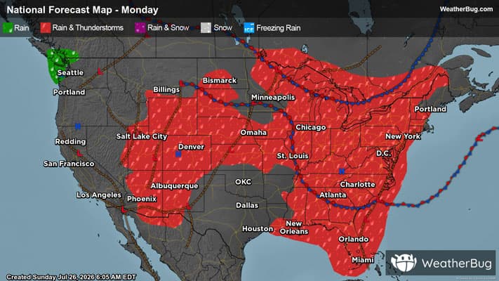
Severe weather may be found across the northern Plains this afternoon, with these storms slowly progressing east and reaching the East Coast by the early to middle part of next week.
Read More
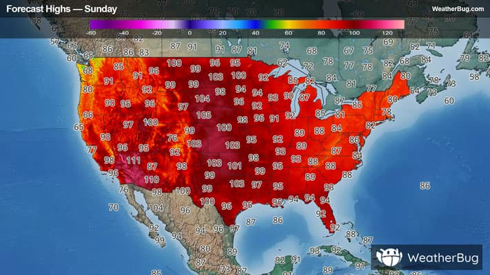
# HEADLINE -------------------- HEAT ADVISORY IN EFFECT FROM 1 PM TO 8 PM CDT MONDAY EXTREME HEAT WARNING REMAINS IN EFFECT UNTIL 9 PM CDT THIS EVENING # DETAILS -------------------- WHAT For the Extreme Heat Warning, dangerously hot conditions with heat index values up to 115. For the Heat Advisory, heat index values up to 102 expected. WHERE Portions of northwest and west central Iowa, southwest Minnesota, northeast Nebraska, and southeast South Dakota. WHEN For the Extreme Heat Warning, until 9 PM CDT this evening. For the Heat Advisory, from 1 PM to 8 PM CDT Monday. IMPACTS Heat related illnesses increase significantly during extreme heat and high humidity events. Hot temperatures and high humidity may cause heat illnesses. ISSUED AT Sunday, July 26, 2026 at 12:39 PM CDT ISSUED BY National Weather Service Sioux Falls SD HEADER URGENT - WEATHER MESSAGE # PRECAUTIONARY/PREPAREDNESS ACTIONS -------------------- Drink plenty of fluids, stay in an air-conditioned room, stay out of the sun, and check up on relatives and neighbors. Do not leave young children and pets in unattended vehicles. Car interiors will reach lethal temperatures in a matter of minutes. Take extra precautions when outside. Wear lightweight and loose fitting clothing. Try to limit strenuous activities to early morning or evening. Take action when you see symptoms of heat exhaustion and heat stroke. To reduce risk during outdoor work, the Occupational Safety and Health Administration recommends scheduling frequent rest breaks in shaded or air conditioned environments. Anyone overcome by heat should be moved to a cool and shaded location. Heat stroke is an emergency! Call 9 1 1. # AREAS AFFECTED -------------------- Buena Vista, Cherokee, Clay, Clay, Cottonwood, Dakota, Dickinson, Dixon, Ida, Jackson, O'Brien, Osceola, Plymouth, Sioux, Union, Woodbury Including the cities of Rock Valley, Hartley, Windom, Mountain Lake, Holstein, Storm Lake, Beresford, Sioux City, Elk Point, Spirit Lake, Ponca, North Sioux City, Milford, Wakefield, Sioux Center, Sheldon, Arnolds Park, Jackson, Spencer, South Sioux City, Orange City, Allen, Hull, Cherokee, Ida Grove, Lakefield, Le Mars, Alcester, Battle Creek, Jefferson, Sibley, Sanborn, Vermillion, and Hawarden
# HEADLINE -------------------- HEAT ADVISORY IN EFFECT FROM 1 PM TO 8 PM CDT MONDAY EXTREME HEAT WARNING REMAINS IN EFFECT UNTIL 9 PM CDT THIS EVENING # DETAILS -------------------- WHAT For the Extreme Heat Warning, dangerously hot conditions with heat index values up to 115. For the Heat Advisory, heat index values up to 102 expected. WHERE Portions of northwest and west central Iowa, southwest Minnesota, northeast Nebraska, and southeast South Dakota. WHEN For the Extreme Heat Warning, until 9 PM CDT this evening. For the Heat Advisory, from 1 PM to 8 PM CDT Monday. IMPACTS Heat related illnesses increase significantly during extreme heat and high humidity events. Hot temperatures and high humidity may cause heat illnesses. ISSUED AT Sunday, July 26, 2026 at 12:39 PM CDT ISSUED BY National Weather Service Sioux Falls SD HEADER URGENT - WEATHER MESSAGE # PRECAUTIONARY/PREPAREDNESS ACTIONS -------------------- Drink plenty of fluids, stay in an air-conditioned room, stay out of the sun, and check up on relatives and neighbors. Do not leave young children and pets in unattended vehicles. Car interiors will reach lethal temperatures in a matter of minutes. Take extra precautions when outside. Wear lightweight and loose fitting clothing. Try to limit strenuous activities to early morning or evening. Take action when you see symptoms of heat exhaustion and heat stroke. To reduce risk during outdoor work, the Occupational Safety and Health Administration recommends scheduling frequent rest breaks in shaded or air conditioned environments. Anyone overcome by heat should be moved to a cool and shaded location. Heat stroke is an emergency! Call 9 1 1. # AREAS AFFECTED -------------------- Buena Vista, Cherokee, Clay, Clay, Cottonwood, Dakota, Dickinson, Dixon, Ida, Jackson, O'Brien, Osceola, Plymouth, Sioux, Union, Woodbury Including the cities of Rock Valley, Hartley, Windom, Mountain Lake, Holstein, Storm Lake, Beresford, Sioux City, Elk Point, Spirit Lake, Ponca, North Sioux City, Milford, Wakefield, Sioux Center, Sheldon, Arnolds Park, Jackson, Spencer, South Sioux City, Orange City, Allen, Hull, Cherokee, Ida Grove, Lakefield, Le Mars, Alcester, Battle Creek, Jefferson, Sibley, Sanborn, Vermillion, and Hawarden
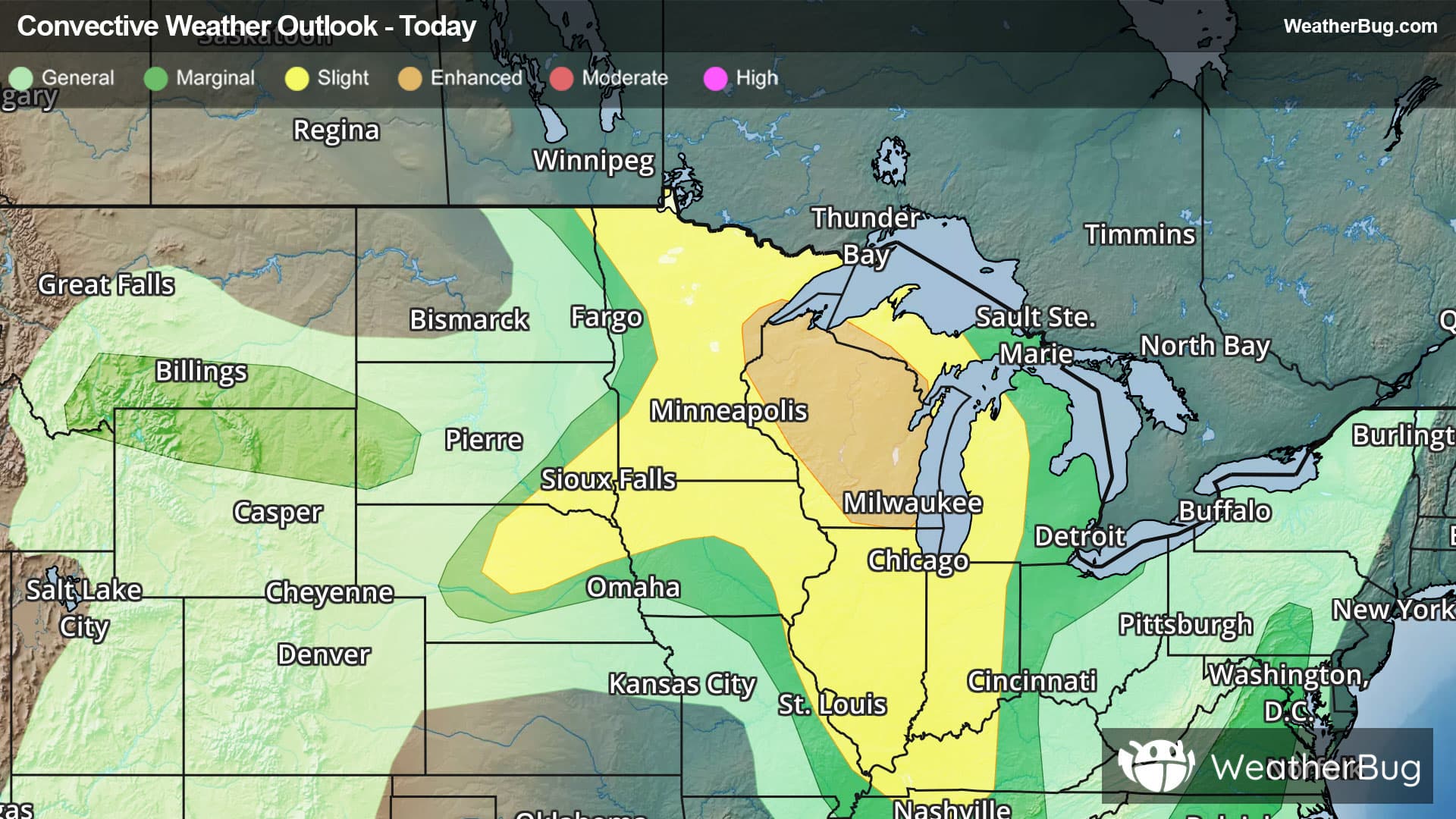
There is a Slight Severe Storm Risk for your location. Continue reading for today's outlook from the National Weather Service's Storm Prediction Center. -------------------- National Severe Storm Outlook THERE IS AN ENHANCED RISK OF SEVERE THUNDERSTORMS OVER PORTIONS OF THE UPPER MIDWEST AND WESTERN GREAT LAKES SUMMARY Severe thunderstorms capable of large to very large hail, damaging winds (possibly 75+ mph), and tornado risk remain likely from the upper Mississippi Valley and Great Lakes southwestward into Nebraska, mainly late this afternoon and tonight. 20Z Update Upper Midwest No changes were made to the prior outlook. Severe storm development remains likely this afternoon and evening as a very warm air mass continues to destabilize. Weak, but sufficient, synoptic ascent (evident in visible imagery) should aid in removing inhibition by late this afternoon. Initial supercells developing over northeastern MN and far northern WI will pose an all-hazards risk, including locally severe wind gusts, very large hail, and a couple of tornadoes. An MCS should eventually develop and track south/southeast across WI and MI with a risk for damaging gusts and a brief tornado or two through tonight. NE More isolated higher-based convection remains possible from central and eastern NE, into western IA, and southeast SD late this afternoon and evening. Very hot surface temperatures and moderate buoyancy will support a few stronger storms with damaging wind and isolated hail potential. Convective development appears most probable along a thermally induced surface pressure trough, from central NE northeastward late this afternoon. Mid MS Valley A very unstable and weakly capped air mass is present along a diffuse differential heating zone from northwest IL, into northern TN. Current expectations are for one or more clusters of thunderstorms to develop along the boundary and ahead of a weak mid-level wave/MCV across IA/IL, before spreading south/southeastward into this evening. The extreme instability (4000+ J/kg MLCAPE) and 25-35 kt of deep-layer shear should support organized clusters, and eventually an MCS, with damaging winds likely. A tornado or two is also possible with initial convection along the boundary owing to extreme buoyancy, or any embedded QLCS circulations with the expected MCS. See MCD#1742 for short-term information. Elsewhere, isolated damaging gusts remain possible with scattered thunderstorms over the northern Rockies and across the Mid Atlantic/Southeast. Weaker buoyancy/shear overlap suggests these occurrences will be more sporadic, with limited storm organization/longevity. See the prior discussion for additional information.