

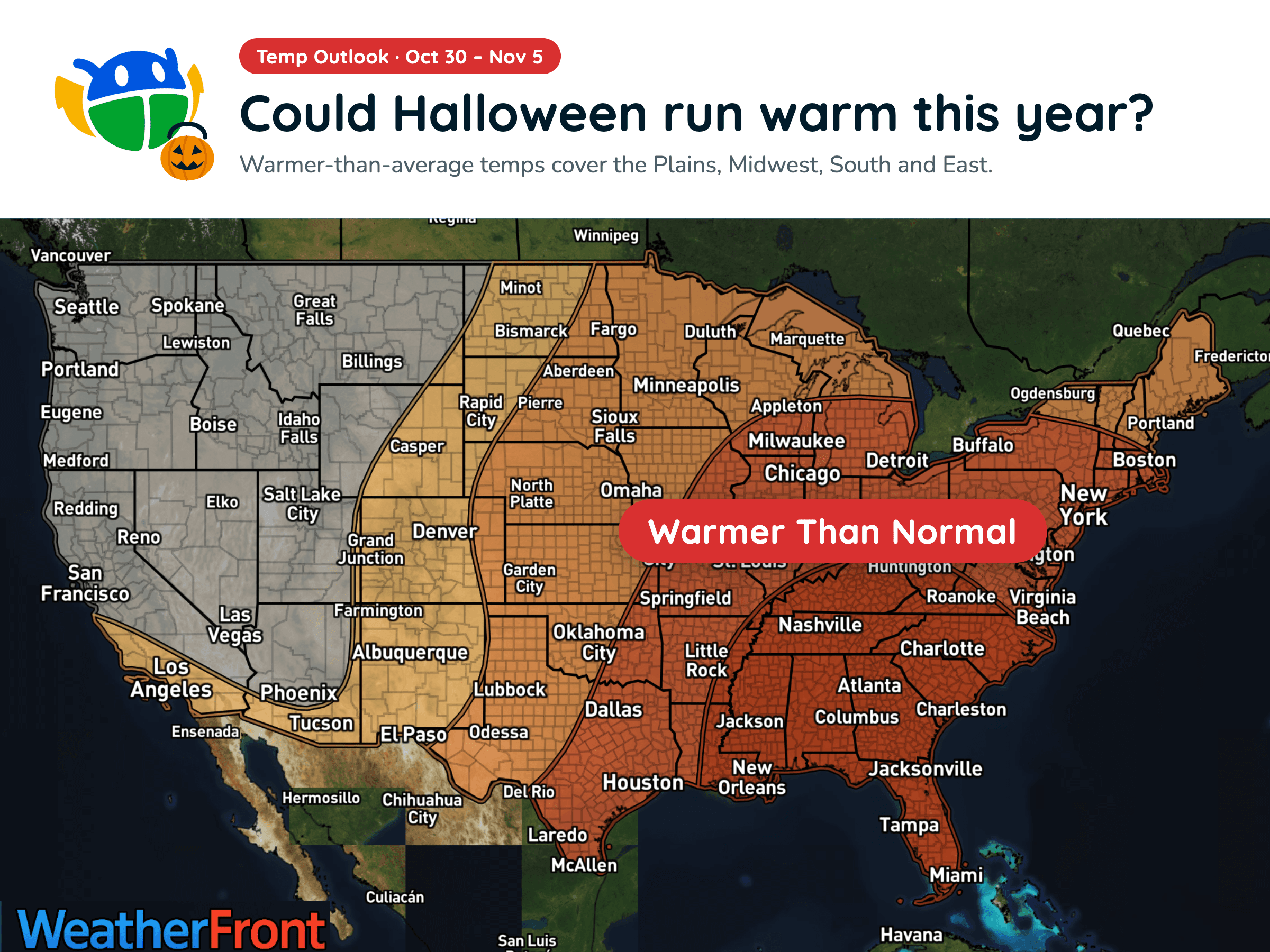
Halloween Weather Outlook: A Warm-Up for Much of the U.S. 🎃
Warmer-than-average temperatures could stick around into early November, but will you need a jacket over your Halloween costume?
Read More
# HEADLINE -------------------- FLOOD WATCH NOW IN EFFECT THROUGH SUNDAY MORNING # DETAILS -------------------- WHAT Flooding caused by excessive rainfall continues to be possible. WHERE Portions of southwest Colorado, including the following areas, Animas River Basin, Four Corners/Upper Dolores River, San Juan River Basin and Southwest San Juan Mountains and Utah, including the following areas, Arches/Grand Flat, Canyonlands/Natural Bridges, La Sal and Abajo Mountains and Southeast Utah. WHEN Through Sunday morning. IMPACTS Excessive runoff may result in flooding of rivers, creeks, streams, recent burn scars and other low-lying and flood-prone locations. Low-water crossings may be flooded. Storm drains and ditches may become clogged with debris. ADDITIONAL DETAILS - Flooding is imminent or ongoing with additional rounds of showers and thunderstorms expected through Saturday afternoon. Rivers and creeks may still experience high waters even after rainfall has ended. - http://www.weather.gov/safety/flood ISSUED AT Friday, October 23, 2026 at 11:59 AM MDT ISSUED BY National Weather Service Grand Junction CO HEADER URGENT - IMMEDIATE BROADCAST REQUESTED | Flood Watch # PRECAUTIONARY/PREPAREDNESS ACTIONS -------------------- You should monitor later forecasts and be alert for possible Flood Warnings. Those living in areas prone to flooding should be prepared to take action should flooding develop. # AREAS AFFECTED -------------------- San Juan River Basin, Animas River Basin, Arches/Grand Flat, Canyonlands/Natural Bridges, Four Corners/Upper Dolores River, La Sal and Abajo Mountains, Northwest San Juan Mountains, Paradox Valley/Lower Dolores River, Southeast Utah, Southwest San Juan Mountains, Uncompahgre Plateau and Dallas Divide Including the cities of Ridgway, Loghill Village, Telluride, Mountain Village, Ouray, Lake City, Sawpit, Pagosa Springs, Silverton, Rico, Nucla, Naturita, Norwood, Slick Rock, Cortez, Mancos, Dolores, Dove Creek, Durango, Bayfield, Ignacio, Blanding, Oljato-Monument Valley, Goulding, Bluff, Tselakai Dezza, Aneth, Montezuma Creek, Mexican Hat, Halchita, White Mesa, Moab, Green River, Castle Valley, Monticello, La Sal, Eastland, Spanish Valley, Fry Canyon, and Canyonlands National Park
Closest strike: 3.41 miles Stay Alert! Remain in a safe area until there has been no lightning within 10 miles of this location for 30 minutes. Please be aware that lightning activity can remain high even when a storm is moving away from your location. Even if rain has stopped, do not leave your safe area until WeatherBug indicates that lightning is more than 10 miles away from this selected location. IF OUTDOORS Avoid water, high ground, and open spaces. Avoid all metal objects including electric wires, fences, and machinery. Find a safe area in a building or in a fully enclosed vehicle with the windows completely shut. Unsafe places include underneath canopies, small picnic or rain shelters, convertibles, or near trees. IF INDOORS Avoid water and stay away from doors and windows. Avoid using a hard line telephone. Take off headphones. Turn off, unplug, and stay away from appliances, computers, power tools, and TV sets. Lightning may strike exterior electric and phone lines, inducing shocks to inside equipment.
There is a Marginal Severe Storm Risk for your location. Continue reading for today's outlook from the National Weather Service's Storm Prediction Center. -------------------- National Severe Storm Outlook THERE IS A SLIGHT RISK OF SEVERE THUNDERSTORMS THIS AFTERNOON AND EVENING OVER PARTS OF NEW MEXICO AND FAR WEST TX SUMMARY Severe wind/hail and a tornado are possible across portions of New Mexico and far west Texas today. NM/Four Corners/Far West TX Recent satellite imagery continues to show a cyclone centered over the Lower CO River Valley with expansive ridging downstream from the western Gulf through the Upper Great Lakes. A shortwave trough is currently progressing through the southeastern periphery of the Lower CO Valley cyclone over northwestern Mexico. General expectation is for the shortwave trough to continue northeastward today with some loss of amplitude as it moves within the confluent flow between the western CONUS upper low and central/eastern CONUS ridging. Persistence of mostly southwesterly flow aloft will continue to promote showers and thunderstorms from the Four Corners vicinity across NM and into far west TX. The airmass becomes more stable with northern extent but should remain buoyant enough to support continued thunderstorms. More widespread cloud cover is anticipated across northern portions of the region, but filtered daytime heating may result in greater destabilization and attendant risk of a few strong/severe storms capable of hail. Greater buoyancy is expected farther south, where dewpoints will likely be in the upper 50s to low 60s amid afternoon highs in the mid/upper 70s. Moderate to strong deep-layer vertical shear will persist across area as well, supporting the potential for supercells. Additionally, a more southeasterly component to the low-level flow is possible from south-central/southeast NM into far west TX, which could support slower storm motions and a relatively greater potential for hail and tornadoes. Some very large hail greater than 2" in diameter is also more possible here. This region should also experience greater large-scale ascent as the shortwave trough moves through during the late afternoon/early evening. This greater ascent could result in a more linear mode and the potential for a few bowing segments. Overall, there appears to be a relatively greater severe potential from south-central NM into southeast NM and far west TX compared to areas farther north and west.
Warmer-than-average temperatures could stick around into early November, but will you need a jacket over your Halloween costume?







