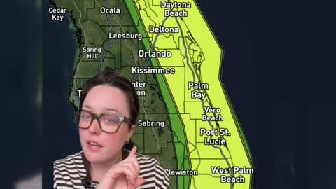
Florida Faces Another Round of Heavy Rain and Flash Flooding
Parts of Florida's East Coast could see significant flooding this week as repeated rounds of heavy rain move through the state.
Read More
# HEADLINE -------------------- BEACH HAZARDS STATEMENT REMAINS IN EFFECT THROUGH THIS AFTERNOON HIGH SURF ADVISORY REMAINS IN EFFECT FROM 4 PM THIS AFTERNOON TO 4 PM PST THURSDAY # DETAILS -------------------- WHAT For the Beach Hazards Statement, An increased risk for sneaker waves and strong rip currents with breaking waves of 13 to 17 ft. For the High Surf Advisory, Large breaking waves of 15 to 18 ft. WHERE All Pacific Coast Beaches. WHEN For the Beach Hazards Statement, through this afternoon. For the High Surf Advisory, from 4 PM today to 4 PM PST Thursday. IMPACTS Large breaking waves can overpower swimmers, pulling people into the sea from beaches, jetties, and rocks resulting in significant physical injury and increasing the risk of drowning. Waves can sweep across the shoreline without warning, pulling people into the sea from beaches, jetties, and rocks. ISSUED AT Wednesday, November 18, 2026 at 3:25 AM PST ISSUED BY National Weather Service San Francisco CA HEADER Coastal Hazard Message # PRECAUTIONARY/PREPAREDNESS ACTIONS -------------------- Swimmers should remain out of the water due to dangerous surf conditions. Stay off of jetties, piers, rocks, and other waterside infrastructure. Remain out of the water to avoid hazardous surf and NEVER turn your back on the ocean. Monitor local weather, surf and tide forecasts at www.weather.gov/mtr. # AREAS AFFECTED -------------------- Coastal North Bay Including Point Reyes National Seashore- San Francisco Peninsula Coast-Northern Monterey Bay- Southern Monterey Bay and Big Sur Coast-
# HEADLINE -------------------- FLASH FLOOD WATCH FOR THE TIMBER AND PLASKETT BURN AREA REMAINS IN EFFECT THROUGH LATE TONIGHT # DETAILS -------------------- WHAT Flash flooding and debris flows caused by excessive rainfall are possible over the Plaskett and Timber burn areas. WHERE - For the Timber Scar, portions of CA Highway 1 and the Los Padres National Forecast from Andrew Molera State Park to Partington Ridge including the town of Big Sur. - For the Plaskett Scar, areas near CA Highway 1 mile marker 17 to mile marker 11 including Los Burros Road. WHEN Through late tonight. IMPACTS - Heavy rainfall over the Timber and Plaskett burn areas is expected during the watch period. Residents near the Timber burn area should prepare for potential debris flow moving through the drainages within Lafler, Castro, and Graves Canyons, as well as drainages between Grimes and Castro Canyons. - Residents near the Plaskett burn area should prepare for potential debris flow moving through the Alder, Plaskett, and Prewitt Creeks. - Be sure to stay up to date with information from local authorities. Heavy rainfall could trigger flash flooding of low-lying areas, roadway flooding, and debris flows in and near recent wildfire burn scars. ADDITIONAL DETAILS - National Weather Service Meteorologists are forecasting heavy rainfall over the Timber and Plaskett burn areas, which may lead to flash flooding and debris flows. - SOME LOCATIONS THAT MAY EXPERIENCE FLASH FLOODING INCLUDE - Big Sur, Plaskett, and Pfeiffer Big Sur State Park - http://www.weather.gov/safety/flood ISSUED AT Wednesday, November 18, 2026 at 4:46 AM PST ISSUED BY National Weather Service San Francisco CA HEADER Flood Watch # PRECAUTIONARY/PREPAREDNESS ACTIONS -------------------- You should monitor later forecasts and be prepared to take action should Flash Flood Warnings be issued. Local emergency services are monitoring the situation and will issue a public statement as conditions warrant. PLAN NOW so you will know what to do in an emergency. Keep informed by listening to local radio and television for statements and possible warnings. Follow the advice of public safety officials. # AREAS AFFECTED -------------------- Santa Lucia Mountains and Los Padres National Forest, Southern Monterey Bay and Big Sur Coast Including the cities of Marina, Monterey, and Seaside
# HEADLINE -------------------- BEACH HAZARDS STATEMENT REMAINS IN EFFECT THROUGH THIS AFTERNOON HIGH SURF ADVISORY REMAINS IN EFFECT FROM 4 PM THIS AFTERNOON TO 4 PM PST THURSDAY # DETAILS -------------------- WHAT For the Beach Hazards Statement, An increased risk for sneaker waves and strong rip currents with breaking waves of 13 to 17 ft. For the High Surf Advisory, Large breaking waves of 15 to 18 ft. WHERE All Pacific Coast Beaches. WHEN For the Beach Hazards Statement, through this afternoon. For the High Surf Advisory, from 4 PM today to 4 PM PST Thursday. IMPACTS Large breaking waves can overpower swimmers, pulling people into the sea from beaches, jetties, and rocks resulting in significant physical injury and increasing the risk of drowning. Waves can sweep across the shoreline without warning, pulling people into the sea from beaches, jetties, and rocks. ISSUED AT Wednesday, November 18, 2026 at 3:25 AM PST ISSUED BY National Weather Service San Francisco CA HEADER Coastal Hazard Message # PRECAUTIONARY/PREPAREDNESS ACTIONS -------------------- Swimmers should remain out of the water due to dangerous surf conditions. Stay off of jetties, piers, rocks, and other waterside infrastructure. Remain out of the water to avoid hazardous surf and NEVER turn your back on the ocean. Monitor local weather, surf and tide forecasts at www.weather.gov/mtr. # AREAS AFFECTED -------------------- Coastal North Bay Including Point Reyes National Seashore- San Francisco Peninsula Coast-Northern Monterey Bay- Southern Monterey Bay and Big Sur Coast-
# HEADLINE -------------------- WIND ADVISORY REMAINS IN EFFECT UNTIL 1 PM PST THIS AFTERNOON # DETAILS -------------------- WHAT South winds 20 to 30 mph with gusts up to 50 mph expected. WHERE East Bay Interior Valleys. WHEN Until 1 PM PST this afternoon. IMPACTS Gusty winds will blow around unsecured objects. Tree limbs could be blown down and a few power outages may result. ISSUED AT Wednesday, November 18, 2026 at 3:18 AM PST ISSUED BY National Weather Service San Francisco CA HEADER URGENT - WEATHER MESSAGE # PRECAUTIONARY/PREPAREDNESS ACTIONS -------------------- Winds this strong can make driving difficult, especially for high profile vehicles. Use extra caution. # AREAS AFFECTED -------------------- Coastal North Bay, San Francisco Including Point Reyes National Seashore-San Francisco Peninsula Coast-East Bay Interior Valleys- Northern Monterey Bay-Southern Monterey Bay and Big Sur Coast-
Parts of Florida's East Coast could see significant flooding this week as repeated rounds of heavy rain move through the state.