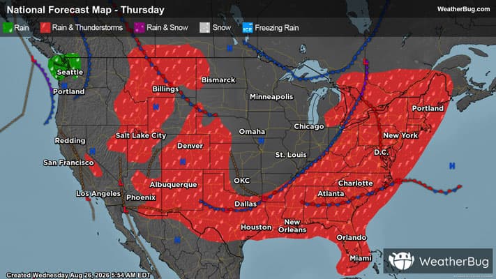
Winds and Hail Fall Across Central U.S.
Severe storms will romp again across multiple corners of the central U.S. today.
Read More
# HEADLINE -------------------- HEAT ADVISORY NOW IN EFFECT UNTIL 8 PM CDT THURSDAY # DETAILS -------------------- WHAT Heat index values of 105 to 108 expected. WHERE Portions of north and central Texas. WHEN Until 8 PM CDT Thursday. IMPACTS Hot temperatures and high humidity will increase the risk for heat-related illnesses to occur, particularly for those working or participating in outdoor activities. ISSUED AT Wednesday, August 26, 2026 at 11:20 AM CDT ISSUED BY National Weather Service Fort Worth TX HEADER URGENT - WEATHER MESSAGE # PRECAUTIONARY/PREPAREDNESS ACTIONS -------------------- Take extra precautions when outside by staying hydrated, wearing lightweight and loose fitting clothing, and limiting strenuous activities to the early morning or evening. Check up on relatives and neighbors. Never leave young children or pets in an enclosed vehicle, even for a short time, as temperatures can quickly rise to life-threatening levels. Know the signs and symptoms of heat exhaustion and heat stroke. To reduce risk when outdoors, the occupational safety and health administration recommends scheduling frequent rest breaks in shaded or air conditioned environments. Anyone overcome by heat should be moved to a cool and shaded location. Heat stroke is an emergency! Call 911 ASAP if you or someone you know is exhibiting signs of heat stroke. # AREAS AFFECTED -------------------- Coryell, Johnson, Tarrant, Anderson, Bell, Bosque, Collin, Dallas, Delta, Denton, Ellis, Falls, Fannin, Freestone, Grayson, Henderson, Hill, Hood, Hopkins, Hunt, Kaufman, Lamar, Leon, Limestone, McLennan, Milam, Navarro, Parker, Rains, Robertson, Rockwall, Somervell, Van Zandt, Wise Including the cities of Bonham, Weatherford, Fort Worth, Mexia, Centerville, Wills Point, Athens, Gun Barrel City, Clifton, Normangee, Palestine, Midlothian, Buffalo, Rockwall, Groesbeck, Temple, Corsicana, Bridgeport, Calvert, Decatur, Cameron, Rockdale, Paris, Greenville, Copperas Cove, Frisco, Waxahachie, Meridian, Fort Hood, Hearne, Allen, Cleburne, Grand Saline, East Tawakoni, Briar, Terrell, Oak Trail Shores, Glen Rose, Teague, Waco, Dallas, Forney, McKinney, Denison, Carrollton, Flower Mound, Van, Fairfield, Hillsboro, Edgewood, Franklin, Kaufman, Granbury, Sherman, Ennis, Commerce, Canton, Arlington, Jewett, Valley Mills, Oakwood, Burleson, Point, Killeen, Marlin, Heath, Plano, Gatesville, Lewisville, Emory, Wortham, Sulphur Springs, Cooper, and Denton
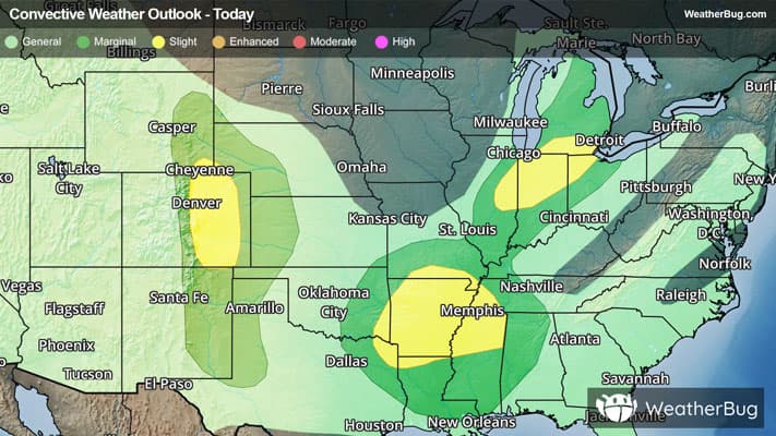
There is a Marginal Severe Storm Risk for your location. Continue reading for today's outlook from the National Weather Service's Storm Prediction Center. -------------------- National Severe Storm Outlook THERE IS A SLIGHT RISK OF SEVERE THUNDERSTORMS FOR PARTS OF THE CENTRAL HIGH PLAINS...AND ALSO FROM THE ARKLATEX TO THE ARKLAMISS REGIONS SUMMARY Isolated to widely scattered strong to severe thunderstorms remain possible tonight across parts of the central and southern High Plains, parts of Arkansas into the lower Mississippi Valley, and parts of the Midwest and Ohio Valley. Central/southern High Plains Widely scattered strong to severe storms are ongoing this evening across parts of the central/southern High Plains. The most favorable environment resides from eastern CO into western KS, with moderate buoyancy and effective shear of 30-40 kt within a northwesterly flow regime. The strongest discrete cells in this area will continue to pose a threat of hail and localized severe gusts. Some modest clustering remains possible with time, which could result in at least an isolated severe-wind threat as convection spreads into western KS later tonight. Deep-layer flow/shear is generally weaker across the southern High Plains, but localized strong to severe gusts will remain possible within the well-mixed environment through at least dusk. AR into the Lower MS Valley Widespread deep convection from southeastern OK into central/southern AR may eventually evolve into a loosely organized, outflow-driven cluster with time this evening. This could result in a threat for scattered wind damage spreading into northern LA through the evening, with an isolated threat possible later tonight as storms approach the LA/MS Gulf Coasts. Midwest/Ohio Valley Scattered storms are ongoing from parts of Lower MI into parts of the Midwest/Ohio Valley. The combination of moderate buoyancy and marginal deep-layer shear (generally 25-35 kt of effective shear) has only been supportive of an isolated severe threat thus far. No substantial improvement in the environment is expected through the evening, but ongoing storms may continue to pose an isolated severe threat before convection generally subsides later tonight.
Pollen Index: 8.3 Pollen Level: medium-high Predominant Pollen: Chenopods, Elm and Grass. Based on past pollen counts and expected weather conditions, pollen levels for Thursday will remain stable in the high range. Pollen producing plants are at a relatively steady level of pollination at this time.
Air Quality Index: 61 Air Quality Level: low Be careful when outside today, Air Quality is low.