Scorching Heat Wave Sizzles In The Central U.S.
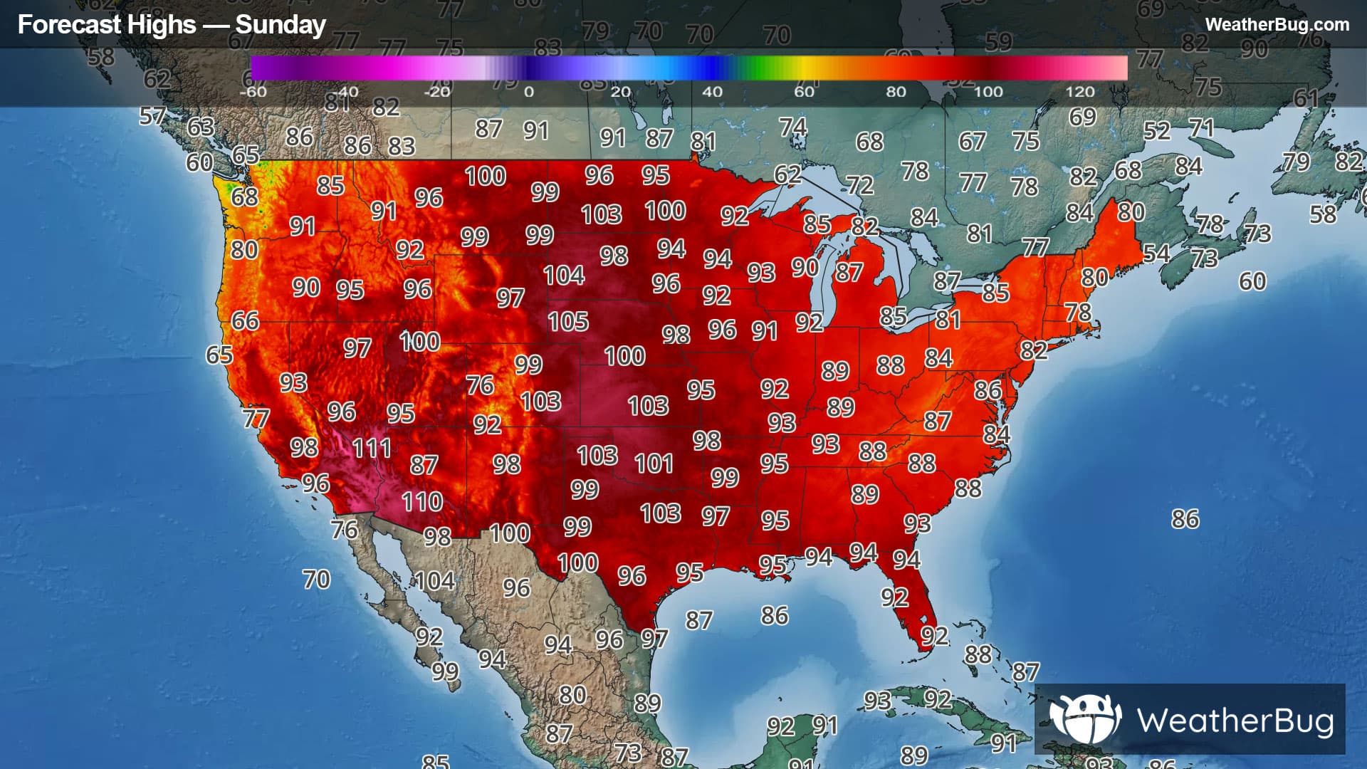
A heat dome is bringing scorching temperatures to the Central U.S. through the weekend and into the start of next week.
Read More
# SUMMARY -------------------- SEVERE THUNDERSTORM WATCH 515 REMAINS VALID UNTIL 2 AM CDT SUNDAY FOR THE FOLLOWING AREAS IN IOWA THIS WATCH INCLUDES 9 COUNTIES IN NORTHWEST IOWA BUENA VISTA CHEROKEE CLAY DICKINSON LYON O'BRIEN OSCEOLA PLYMOUTH SIOUX IN MINNESOTA THIS WATCH INCLUDES 4 COUNTIES IN SOUTHWEST MINNESOTA COTTONWOOD JACKSON MURRAY NOBLES THIS INCLUDES THE CITIES OF ARNOLDS PARK, CHEROKEE, FULDA, GEORGE, HARTLEY, HAWARDEN, HULL, INWOOD, JACKSON, LAKEFIELD, LARCHWOOD, LE MARS, MILFORD, MOUNTAIN LAKE, ORANGE CITY, ROCK RAPIDS, ROCK VALLEY, SANBORN, SHELDON, SIBLEY, SIOUX CENTER, SLAYTON, SPENCER, SPIRIT LAKE, STORM LAKE, WINDOM, AND WORTHINGTON. # DETAILS -------------------- ISSUED AT Saturday, July 25, 2026 at 10:24 PM CDT ISSUED BY NATIONAL WEATHER SERVICE SIOUX FALLS SD HEADER WATCH COUNTY NOTIFICATION FOR WATCHES 513/515
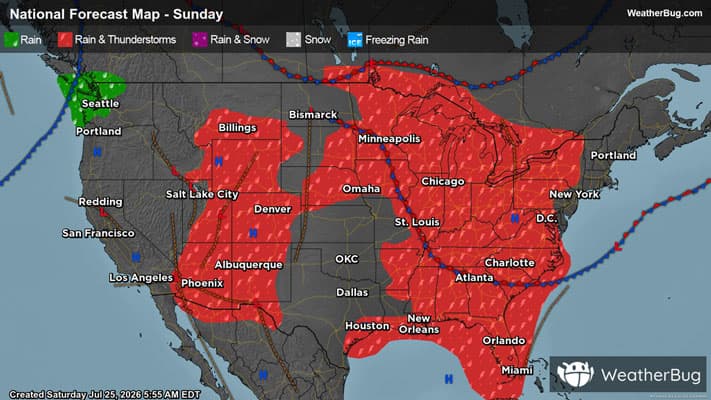
# HEADLINE -------------------- A SEVERE THUNDERSTORM WARNING REMAINS IN EFFECT UNTIL 1030 PM CDT FOR CHEROKEE, NORTHEASTERN WOODBURY, SIOUX, PLYMOUTH, WESTERN BUENA VISTA, SOUTHERN CLAY, O'BRIEN AND NORTHWESTERN IDA COUNTIES # SUMMARY -------------------- At 1010 PM CDT, severe thunderstorms were located along a line extending from near Spencer In Clay County to near Cherokee to near Moville, moving east at 50 mph. # DETAILS -------------------- HAZARD 60 mph wind gusts. SOURCE Radar indicated. IMPACT Expect damage to roofs, siding, and trees. LOCATIONS IMPACTED INCLUDE Cherokee, Aurelia, Correctionville, Sioux Rapids, Pierson, Quimby, Washta, Linn Grove, Greenville, Alta, Anthon, Cushing, Webb and Holstein. ISSUED AT Saturday, July 25, 2026 at 10:10 PM CDT ISSUED BY National Weather Service Sioux Falls SD HEADER Severe Weather Statement # PRECAUTIONARY/PREPAREDNESS ACTIONS -------------------- For your protection move to an interior room on the lowest floor of a building. To report severe weather contact your nearest law enforcement agency. They will send your report to the National Weather Service office in Sioux Falls. # AREAS AFFECTED -------------------- O'Brien IA, Buena Vista IA, Cherokee IA, Clay IA, Ida IA, Plymouth IA, Sioux IA, Woodbury IA
# HEADLINE -------------------- EXTREME HEAT WARNING IN EFFECT UNTIL 8 PM CDT SUNDAY # DETAILS -------------------- WHAT Dangerously hot conditions with heat index values up to 110. WHERE Portions of northwest and west central Iowa, southwest Minnesota, and east central and southeast South Dakota. WHEN Until 8 PM CDT Sunday. IMPACTS Heat related illnesses increase significantly during extreme heat and high humidity events. ISSUED AT Saturday, July 25, 2026 at 4:30 PM CDT ISSUED BY National Weather Service Sioux Falls SD HEADER URGENT - WEATHER MESSAGE # PRECAUTIONARY/PREPAREDNESS ACTIONS -------------------- Drink plenty of fluids, stay in an air-conditioned room, stay out of the sun, and check up on relatives and neighbors. Do not leave young children and pets in unattended vehicles. Car interiors will reach lethal temperatures in a matter of minutes. Take extra precautions when outside. Wear lightweight and loose fitting clothing. Try to limit strenuous activities to early morning or evening. Take action when you see symptoms of heat exhaustion and heat stroke. To reduce risk during outdoor work, the Occupational Safety and Health Administration recommends scheduling frequent rest breaks in shaded or air conditioned environments. Anyone overcome by heat should be moved to a cool and shaded location. Heat stroke is an emergency! Call 9 1 1. # AREAS AFFECTED -------------------- Kingsbury, Lincoln, Brookings, Buena Vista, Cherokee, Clay, Cottonwood, Dickinson, Ida, Jackson, Lake, Lyon, Lyon, McCook, Miner, Minnehaha, Moody, Murray, Nobles, O'Brien, Osceola, Pipestone, Rock Including the cities of Hendricks, Storm Lake, Howard, Larchwood, Ida Grove, Lake Preston, Madison, Fulda, Arlington, Sanborn, Orland, George, Luverne, Ivanhoe, Sheldon, Hartley, Milford, Holstein, Mountain Lake, Canistota, Sioux Falls, Sibley, Rock Rapids, Spirit Lake, Cherokee, Lakefield, Spencer, Pipestone, Inwood, Slayton, Tyler, De Smet, Brookings, Bridgewater, Salem, Worthington, Arnolds Park, Jackson, Windom, Lake Benton, Flandreau, Marshall, Battle Creek, and Montrose
Closest strike: 3.74 miles Stay Alert! Remain in a safe area until there has been no lightning within 10 miles of this location for 30 minutes. Please be aware that lightning activity can remain high even when a storm is moving away from your location. Even if rain has stopped, do not leave your safe area until WeatherBug indicates that lightning is more than 10 miles away from this selected location. IF OUTDOORS Avoid water, high ground, and open spaces. Avoid all metal objects including electric wires, fences, and machinery. Find a safe area in a building or in a fully enclosed vehicle with the windows completely shut. Unsafe places include underneath canopies, small picnic or rain shelters, convertibles, or near trees. IF INDOORS Avoid water and stay away from doors and windows. Avoid using a hard line telephone. Take off headphones. Turn off, unplug, and stay away from appliances, computers, power tools, and TV sets. Lightning may strike exterior electric and phone lines, inducing shocks to inside equipment.
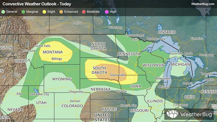
There is a Enhanced Severe Storm Risk for your location. Continue reading for today's outlook from the National Weather Service's Storm Prediction Center. -------------------- National Severe Storm Outlook THERE IS AN ENHANCED RISK OF SEVERE THUNDERSTORMS FOR EASTERN SD...SOUTHWEST MN...NORTHERN IA THERE IS A SLIGHT RISK OF SEVERE THUNDERSTORMS FOR PARTS OF CENTRAL/EASTERN MT SUMMARY Severe gusts (potentially greater than 75 mph) remain possible this evening from eastern South Dakota into northern Iowa and southwest Minnesota. Isolated to widely scattered severe gusts also remain possible across parts of Montana. SD into southern MN/northern IA/far northeast NE A loosely organized storm cluster is moving across eastern SD this evening. Additional intensification remains possible this evening, as this cluster encounters extreme downstream buoyancy, with MLCAPE of 4000-5000 J/kg within a very moist (dewpoints around 80 F) environment. The ongoing cluster has produced measured gusts of 60-80 mph, so any notable intensification could lead to an increase in potential for gusts in the 75-90 mph range. Isolated hail and perhaps a tornado also remain possible through dusk with this cluster. Increasing CINH with time and eastward extent should eventually result in a weakening trend later tonight, though an organized severe threat could eventually approach parts of southeast MN/northeast IA into northwest IL overnight. Farther northwest, a separate storm cluster is moving across north-central SD, within a similarly favorable environment. In the short term, this cluster may continue to move east-southeastward along a surface boundary with a continued severe-wind threat. Eventually, weakening buoyancy in the wake of the southeast SD cluster will tend to result in a weakening trend with this cluster. Central/eastern Montana Strong to locally severe storms may persist through dusk across parts of central/eastern MT, within a well-mixed environment that is favorable for severe-wind potential. Increasing CINH will result in an eventual weakening trend later tonight, though remnant outflows may still produce strong to locally severe gusts as storms diminish. Southern AZ Widely scattered storms and increasing outflow may continue to support strong to localized severe gusts within a very hot and well-mixed environment across parts of southern AZ. Weak deep-layer flow/shear should keep any remaining threat generally disorganized.