

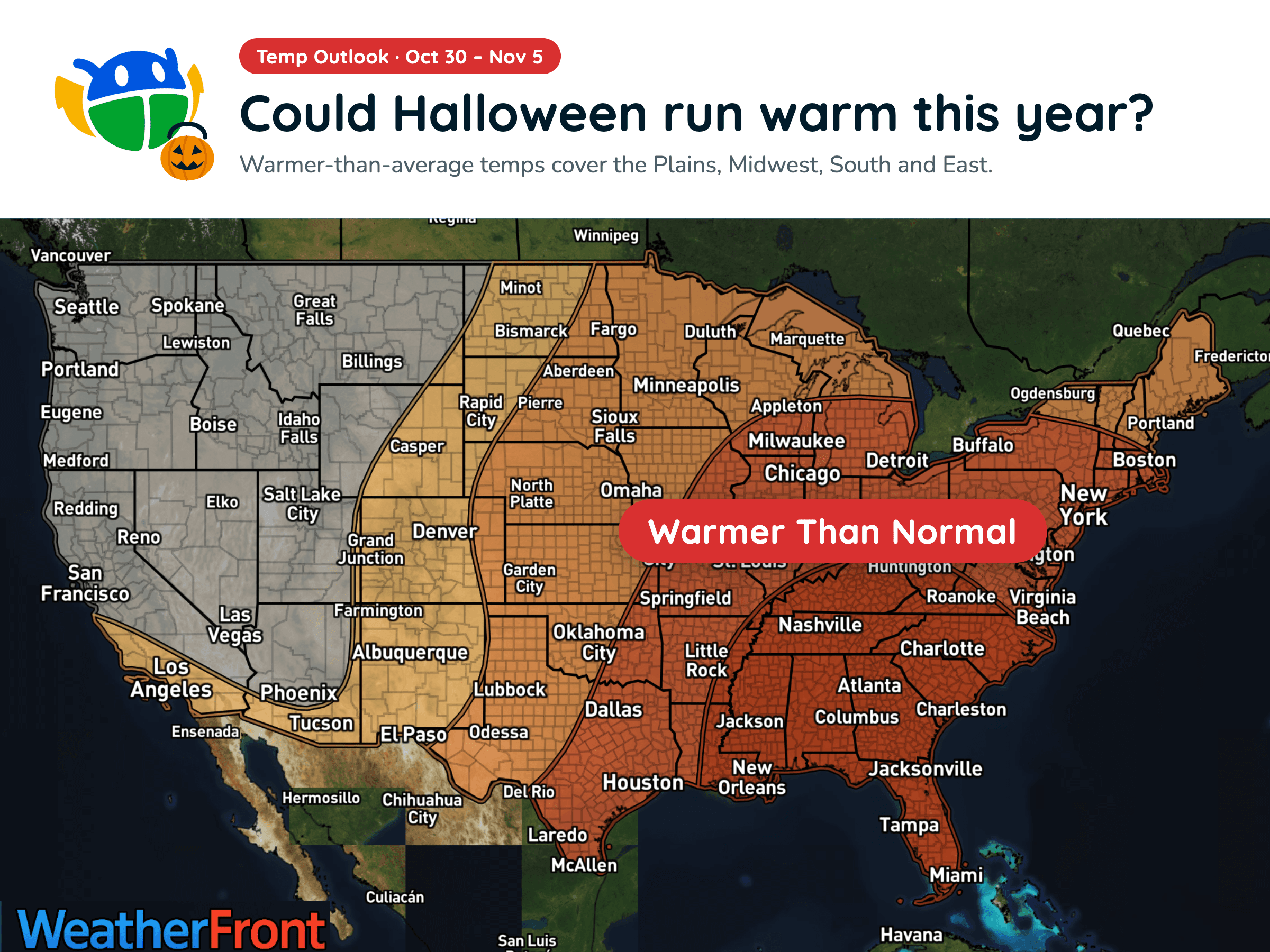
Halloween Weather Outlook: A Warm-Up for Much of the U.S. 🎃
Warmer-than-average temperatures could stick around into early November, but will you need a jacket over your Halloween costume?
Read More
# HEADLINE -------------------- COASTAL FLOOD ADVISORY REMAINS IN EFFECT UNTIL 5 PM EDT THIS AFTERNOON HIGH SURF ADVISORY REMAINS IN EFFECT UNTIL 8 PM EDT MONDAY HIGH RIP CURRENT RISK REMAINS IN EFFECT THROUGH MONDAY EVENING COASTAL FLOOD WARNING REMAINS IN EFFECT FROM 5 PM THIS AFTERNOON TO 8 PM EDT MONDAY # DETAILS -------------------- WHAT For the Coastal Flood Advisory, minor coastal flooding. For the High Surf Advisory, large breaking waves of 6 to 8 feet. For the High Rip Current Risk, dangerous rip currents. For the Coastal Flood Warning, significant coastal flooding expected. WHERE Southeast Georgia Beaches. WHEN For the Coastal Flood Advisory, until 5 PM EDT this afternoon. For the High Surf Advisory, until 8 PM EDT Monday. For the High Rip Current Risk, through Monday evening. For the Coastal Flood Warning, from 5 PM this afternoon to 8 PM EDT Monday. IMPACTS Numerous roads may be closed. Low lying property including homes, businesses, and some critical infrastructure will be inundated. Some shoreline erosion will occur. Dangerous swimming and surfing conditions and localized beach erosion. Rip currents can sweep even the best swimmers away from shore into deeper water. ISSUED AT Saturday, October 24, 2026 at 12:23 PM EDT ISSUED BY National Weather Service Jacksonville FL HEADER Coastal Hazard Message # PRECAUTIONARY/PREPAREDNESS ACTIONS -------------------- Take the necessary actions to protect flood-prone property. If travel is required, do not drive around barricades or through water of unknown depth. Inexperienced swimmers should remain out of the water due to dangerous surf conditions. Swim near a lifeguard. If caught in a rip current, relax and float. Don't swim against the current. If able, swim in a direction following the shoreline. If unable to escape, face the shore and call or wave for help. # AREAS AFFECTED -------------------- Coastal Camden, Coastal Glynn, Coastal Nassau
# HEADLINE -------------------- COASTAL FLOOD ADVISORY REMAINS IN EFFECT UNTIL 5 PM EDT THIS AFTERNOON HIGH SURF ADVISORY REMAINS IN EFFECT UNTIL 8 PM EDT MONDAY HIGH RIP CURRENT RISK REMAINS IN EFFECT THROUGH MONDAY EVENING COASTAL FLOOD WARNING REMAINS IN EFFECT FROM 5 PM THIS AFTERNOON TO 8 PM EDT MONDAY # DETAILS -------------------- WHAT For the Coastal Flood Advisory, minor coastal flooding. For the High Surf Advisory, large breaking waves of 6 to 8 feet. For the High Rip Current Risk, dangerous rip currents. For the Coastal Flood Warning, significant coastal flooding expected. WHERE Southeast Georgia Beaches. WHEN For the Coastal Flood Advisory, until 5 PM EDT this afternoon. For the High Surf Advisory, until 8 PM EDT Monday. For the High Rip Current Risk, through Monday evening. For the Coastal Flood Warning, from 5 PM this afternoon to 8 PM EDT Monday. IMPACTS Numerous roads may be closed. Low lying property including homes, businesses, and some critical infrastructure will be inundated. Some shoreline erosion will occur. Dangerous swimming and surfing conditions and localized beach erosion. Rip currents can sweep even the best swimmers away from shore into deeper water. ISSUED AT Saturday, October 24, 2026 at 12:23 PM EDT ISSUED BY National Weather Service Jacksonville FL HEADER Coastal Hazard Message # PRECAUTIONARY/PREPAREDNESS ACTIONS -------------------- Take the necessary actions to protect flood-prone property. If travel is required, do not drive around barricades or through water of unknown depth. Inexperienced swimmers should remain out of the water due to dangerous surf conditions. Swim near a lifeguard. If caught in a rip current, relax and float. Don't swim against the current. If able, swim in a direction following the shoreline. If unable to escape, face the shore and call or wave for help. # AREAS AFFECTED -------------------- Coastal Camden, Coastal Glynn, Coastal Nassau
# HEADLINE -------------------- COASTAL FLOOD ADVISORY REMAINS IN EFFECT UNTIL 5 PM EDT THIS AFTERNOON HIGH SURF ADVISORY REMAINS IN EFFECT UNTIL 8 PM EDT MONDAY HIGH RIP CURRENT RISK REMAINS IN EFFECT THROUGH MONDAY EVENING COASTAL FLOOD WARNING REMAINS IN EFFECT FROM 5 PM THIS AFTERNOON TO 8 PM EDT MONDAY # DETAILS -------------------- WHAT For the Coastal Flood Advisory, minor coastal flooding. For the High Surf Advisory, large breaking waves of 6 to 8 feet. For the High Rip Current Risk, dangerous rip currents. For the Coastal Flood Warning, significant coastal flooding expected. WHERE Southeast Georgia Beaches. WHEN For the Coastal Flood Advisory, until 5 PM EDT this afternoon. For the High Surf Advisory, until 8 PM EDT Monday. For the High Rip Current Risk, through Monday evening. For the Coastal Flood Warning, from 5 PM this afternoon to 8 PM EDT Monday. IMPACTS Numerous roads may be closed. Low lying property including homes, businesses, and some critical infrastructure will be inundated. Some shoreline erosion will occur. Dangerous swimming and surfing conditions and localized beach erosion. Rip currents can sweep even the best swimmers away from shore into deeper water. ISSUED AT Saturday, October 24, 2026 at 12:23 PM EDT ISSUED BY National Weather Service Jacksonville FL HEADER Coastal Hazard Message # PRECAUTIONARY/PREPAREDNESS ACTIONS -------------------- Take the necessary actions to protect flood-prone property. If travel is required, do not drive around barricades or through water of unknown depth. Inexperienced swimmers should remain out of the water due to dangerous surf conditions. Swim near a lifeguard. If caught in a rip current, relax and float. Don't swim against the current. If able, swim in a direction following the shoreline. If unable to escape, face the shore and call or wave for help. # AREAS AFFECTED -------------------- Coastal Camden, Coastal Glynn, Coastal Nassau
# HEADLINE -------------------- WIND ADVISORY REMAINS IN EFFECT UNTIL 1 AM EDT SUNDAY # DETAILS -------------------- WHAT Northeast winds 20 to 25 mph with gusts up to 45 mph. WHERE In Florida, Coastal Duval, Coastal Flagler, Coastal Nassau, Inland Flagler, Northeast Coastal St. Johns, Northern Inland St. Johns, Southeast Coastal St. Johns, and Southern Inland St. Johns Counties. In Georgia, Coastal Camden and Coastal Glynn Counties. WHEN Until 1 AM EDT Sunday. IMPACTS Gusty winds will blow around unsecured objects. Tree limbs could be blown down and a few power outages may result. ISSUED AT Saturday, October 24, 2026 at 12:18 PM EDT ISSUED BY National Weather Service Jacksonville FL HEADER URGENT - WEATHER MESSAGE # PRECAUTIONARY/PREPAREDNESS ACTIONS -------------------- Winds this strong can make driving difficult, especially for high profile vehicles. Use extra caution. Secure outdoor objects. # AREAS AFFECTED -------------------- Northeast Coastal St. Johns, Coastal Camden, Coastal Duval, Coastal Flagler, Coastal Glynn, Coastal Nassau, Inland Flagler, Northern Inland St. Johns, Southeast Coastal St. Johns, Southern Inland St. Johns Including the cities of Glynn Haven, Country Club Estate, Saint Augustine South, Oceanway, Ponte Vedra Beach, Butler Beach, Durbin, Yulee, Jekyll Island, Bakersville, Sea Island, Dupont Center, Saint Augustine, Dungeness, Espanola, Tallyrand, Dover Bluff, Kingsland, Fernandina Beach, Arlington, Palm Coast, Dock Junction, Amelia City, Jacksonville, Saint Augustine Shore, Bunnell, Saint Augustine Beach, Andalusia, Anastasia, St. Simons, and Palm Valley
Warmer-than-average temperatures could stick around into early November, but will you need a jacket over your Halloween costume?







