Northern Lights This Weekend: Will Clouds Block the View?
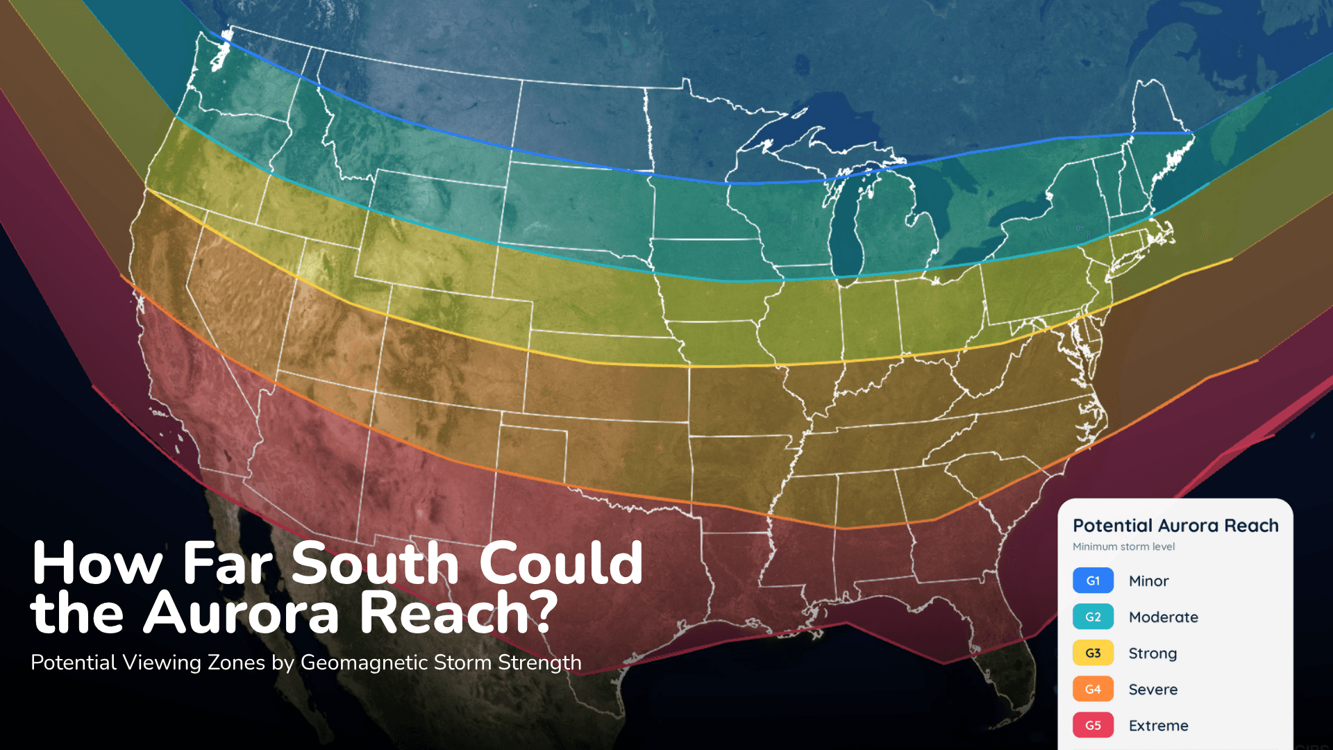
Aurora could reach parts of the northern United States Saturday night, but the cloud forecast may decide who actually sees it.
Read More
# HEADLINE -------------------- FLOOD WATCH REMAINS IN EFFECT THROUGH SUNDAY MORNING # DETAILS -------------------- WHAT Flooding caused by excessive rainfall continues to be possible. WHERE Portions of central, east central, north central, northeast, northwest, southeast, and west central Georgia, including the following areas, in central Georgia, Baldwin, Bibb, Bleckley, Butts, Crawford, Dodge, Houston, Jasper, Jones, Laurens, Monroe, Montgomery, Peach, Pulaski, Putnam, Telfair, Twiggs, Wheeler, Wilcox and Wilkinson. In east central Georgia, Emanuel, Glascock, Greene, Hancock, Jefferson, Johnson, Taliaferro, Treutlen, Warren, Washington and Wilkes. In north central Georgia, Barrow, Cherokee, Clayton, Cobb, Dawson, DeKalb, Douglas, Fannin, Fayette, Forsyth, Gilmer, Gwinnett, Hall, Henry, Lumpkin, Morgan, Newton, North Fulton, Pickens, Rockdale, South Fulton, Union and Walton. In northeast Georgia, Banks, Clarke, Jackson, Madison, Oconee, Oglethorpe, Towns and White. In northwest Georgia, Bartow, Carroll, Catoosa, Chattooga, Dade, Floyd, Gordon, Haralson, Murray, Paulding, Polk, Walker and Whitfield. In southeast Georgia, Toombs. In west central Georgia, Coweta, Heard, Lamar, Meriwether, Pike, Spalding, Troup and Upson. WHEN Through Sunday morning. IMPACTS Excessive runoff may result in flooding of rivers, creeks, streams, and other low-lying and flood-prone locations. Flooding may occur in poor drainage and urban areas. ADDITIONAL DETAILS - Post Tropical Cyclone Isaias will continue to bring bands of moderate to heavy rainfall to the area through Saturday night. Total estimated rainfall so far shows 1 to 4 inches in western Georgia, and lesser amounts to the east. Further bands of heavy rainfall remain possible for eastern Georgia with more steady rainfall across north Georgia. Expected rainfall totals remains at a general 1 to 4 inches with a localized swatch of up to 8 inches possible by event end. Tropical rainfall rates and training bands of thunderstorms may lead to flash and riverine flooding. - http://www.weather.gov/safety/flood ISSUED AT Saturday, October 10, 2026 at 9:57 AM EDT ISSUED BY National Weather Service Peachtree City GA HEADER Flood Watch # PRECAUTIONARY/PREPAREDNESS ACTIONS -------------------- You should monitor later forecasts and be alert for possible Flood Warnings. Those living in areas prone to flooding should be prepared to take action should flooding develop. # AREAS AFFECTED -------------------- Baldwin, Chattooga, Douglas, Forsyth, Gwinnett, Johnson, Putnam, Taliaferro, Wilcox, Banks, Barrow, Bartow, Bibb, Bleckley, Butts, Carroll, Catoosa, Cherokee, Clarke, Clayton, Cobb, Coweta, Crawford, Dade, Dawson, DeKalb, Dodge, Emanuel, Fannin, Fayette, Floyd, Gilmer, Glascock, Gordon, Greene, Hall, Hancock, Haralson, Heard, Henry, Houston, Jackson, Jasper, Jefferson, Jones, Lamar, Laurens, Lumpkin, Madison, Meriwether, Monroe, Montgomery, Morgan, Murray, Newton, North Fulton, Oconee, Oglethorpe, Paulding, Peach, Pickens, Pike, Polk, Pulaski, Rockdale, South Fulton, Spalding, Telfair, Toombs, Towns, Treutlen, Troup, Twiggs, Union, Upson, Walker, Walton, Warren, Washington, Wheeler, White, Whitfield, Wilkes, Wilkinson Including the cities of Douglasville, Soperton, Covington, Gray, Monroe, Blue Ridge, Barnesville, Lawrenceville, Gibson, Jasper, Fort Valley, Jackson, Newnan, Sparta, Fort Oglethorpe, Washington, Atlanta, Eatonton, Crawford, Wrightsville, Abbeville, Crawfordville, Louisville, Gainesville, Sandersville, Alamo, Decatur, Zebulon, Rome, Eastman, Cleveland, Vidalia, Chatsworth, Roberts, Dahlonega, Winder, Madison, Dallas, Forsyth, Mount Vernon, Riverdale, Greensboro, Peachtree City, Comer, Summerville, Monticello, Cochran, LaFayette, Calhoun, Commerce, Carrollton, Bremen, Marietta, Manchester, Warrenton, Thomaston, East Point, Cumming, Mcrae, Dawsonville, Macon, Watkinsville, Trenton, Cedartown, Conyers, West Point, Blairsville, Franklin, Warner Robins, Stockbridge, Woodstock, Homer, Hiawassee, Swainsboro, Hawkinsville, Athens, Jeffersonville, Milledgeville, Dalton, Toomsboro, Griffin, Dublin, Ellijay, and Cartersville
# HEADLINE -------------------- HIGH WIND WARNING REMAINS IN EFFECT UNTIL 8 AM EDT SUNDAY # DETAILS -------------------- WHAT East winds 15 to 25 mph with gusts up to 50 mph expected. Stronger gusts are possible in the higher elevations of the north Georgia mountains. WHERE Portions of north central, northeast, northwest, and west central Georgia. WHEN Until 8 AM EDT Sunday. IMPACTS Damaging winds will blow down trees and power lines. Widespread power outages are expected. Travel will be difficult, especially for high profile vehicles. ISSUED AT Saturday, October 10, 2026 at 5:00 AM EDT ISSUED BY National Weather Service Peachtree City GA HEADER URGENT - WEATHER MESSAGE # PRECAUTIONARY/PREPAREDNESS ACTIONS -------------------- People are urged to secure loose objects that could be blown around or damaged by the wind. Watch for falling debris and tree limbs. Use caution if you must drive. # AREAS AFFECTED -------------------- Chattooga, DeKalb, Forsyth, Gwinnett, Banks, Barrow, Bartow, Carroll, Catoosa, Cherokee, Clarke, Clayton, Cobb, Coweta, Dade, Dawson, Douglas, Fannin, Fayette, Floyd, Gilmer, Gordon, Hall, Haralson, Henry, Jackson, Lumpkin, Madison, Murray, Newton, North Fulton, Oconee, Paulding, Pickens, Polk, Rockdale, South Fulton, Spalding, Towns, Union, Walker, Walton, White, Whitfield Including the cities of Commerce, Ellijay, Dalton, Bremen, Gainesville, Comer, Marietta, Athens, LaFayette, Woodstock, Stockbridge, Jasper, Peachtree City, Winder, Dawsonville, Decatur, Blairsville, Griffin, Covington, Atlanta, Cumming, Summerville, Fort Oglethorpe, Dahlonega, Cedartown, Newnan, East Point, Rome, Cleveland, Carrollton, Hiawassee, Watkinsville, Dallas, Douglasville, Conyers, Calhoun, Blue Ridge, Homer, Riverdale, Chatsworth, Monroe, Trenton, Cartersville, and Lawrenceville
Aurora could reach parts of the northern United States Saturday night, but the cloud forecast may decide who actually sees it.