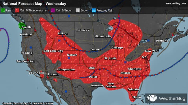
Severe Threats to Hit Tornado Alley, Upper Midwest
Severe storms are set to rumble from the Texas Panhandle to Lake Superior today.
Read More
A Weather Alert has been issued for a nearby area. While your current location is outside of the impacted area, please stay alert and monitor weather conditions. # SUMMARY -------------------- The National Weather Service in Norman has issued a - Severe Thunderstorm Warning for... Northwestern Harmon County in southwestern Oklahoma... West central Greer County in southwestern Oklahoma... Southwestern Beckham County in western Oklahoma... - Until 500 PM CDT. - At 410 PM CDT, a severe thunderstorm was located near Texola, moving south at 20 mph. # DETAILS -------------------- HAZARD 60 mph wind gusts and half dollar size hail. SOURCE Radar indicated. IMPACT Hail damage to vehicles is expected. Expect wind damage to roofs, siding, and trees. LOCATIONS IMPACTED INCLUDE Texola. ISSUED AT Tuesday, August 25, 2026 at 4:11 PM CDT ISSUED BY National Weather Service Norman OK HEADER BULLETIN - IMMEDIATE BROADCAST REQUESTED | Severe Thunderstorm Warning # PRECAUTIONARY/PREPAREDNESS ACTIONS -------------------- For your protection move to an interior room on the lowest floor of a building.
# HEADLINE -------------------- A SEVERE THUNDERSTORM WARNING REMAINS IN EFFECT UNTIL 415 PM CDT FOR SOUTHWESTERN BECKHAM COUNTY # SUMMARY -------------------- At 355 PM CDT, a severe thunderstorm was located near Texola, moving south at 10 mph. # DETAILS -------------------- HAZARD 60 mph wind gusts and quarter size hail. SOURCE Radar indicated. IMPACT Hail damage to vehicles is expected. Expect wind damage to roofs, siding, and trees. LOCATIONS IMPACTED INCLUDE Erick and Texola. ISSUED AT Tuesday, August 25, 2026 at 3:56 PM CDT ISSUED BY National Weather Service Norman OK HEADER Severe Weather Statement # PRECAUTIONARY/PREPAREDNESS ACTIONS -------------------- For your protection move to an interior room on the lowest floor of a building. # AREAS AFFECTED -------------------- Beckham OK
# HEADLINE -------------------- HEAT ADVISORY IN EFFECT FROM 1 PM THIS AFTERNOON TO 7 PM CDT THIS EVENING # DETAILS -------------------- WHAT Heat index values up to 109 expected. WHERE Cleveland, Grady, McClain, Pottawatomie, Seminole, Hughes, Caddo, Beckham, and Washita Counties. WHEN From 1 PM this afternoon to 7 PM CDT this evening. IMPACTS Hot temperatures and high humidity may cause heat illnesses. ISSUED AT Tuesday, August 25, 2026 at 12:09 AM CDT ISSUED BY National Weather Service Norman OK HEADER URGENT - WEATHER MESSAGE # PRECAUTIONARY/PREPAREDNESS ACTIONS -------------------- Drink plenty of fluids, stay in an air-conditioned room, stay out of the sun, and check up on relatives and neighbors. To reduce risk during outdoor work, the Occupational Safety and Health Administration recommends scheduling frequent rest breaks in shaded or air conditioned environments. Anyone overcome by heat should be moved to a cool and shaded location. Heat stroke is an emergency! Call 9 1 1. # AREAS AFFECTED -------------------- Hughes, Beckham, Caddo, Cleveland, Grady, McClain, Pottawatomie, Seminole, Washita Including the cities of Sentinel, Purcell, Chickasha, Anadarko, Tuttle, Wetumka, Wewoka, Newcastle, Norman, Sayre, Seminole, Shawnee, Elk City, Blanchard, Hinton, Moore, Holdenville, Burns Flat, and Cordell
Closest strike: 0.17 miles Stay Alert! Remain in a safe area until there has been no lightning within 10 miles of this location for 30 minutes. Please be aware that lightning activity can remain high even when a storm is moving away from your location. Even if rain has stopped, do not leave your safe area until WeatherBug indicates that lightning is more than 10 miles away from this selected location. IF OUTDOORS Avoid water, high ground, and open spaces. Avoid all metal objects including electric wires, fences, and machinery. Find a safe area in a building or in a fully enclosed vehicle with the windows completely shut. Unsafe places include underneath canopies, small picnic or rain shelters, convertibles, or near trees. IF INDOORS Avoid water and stay away from doors and windows. Avoid using a hard line telephone. Take off headphones. Turn off, unplug, and stay away from appliances, computers, power tools, and TV sets. Lightning may strike exterior electric and phone lines, inducing shocks to inside equipment.
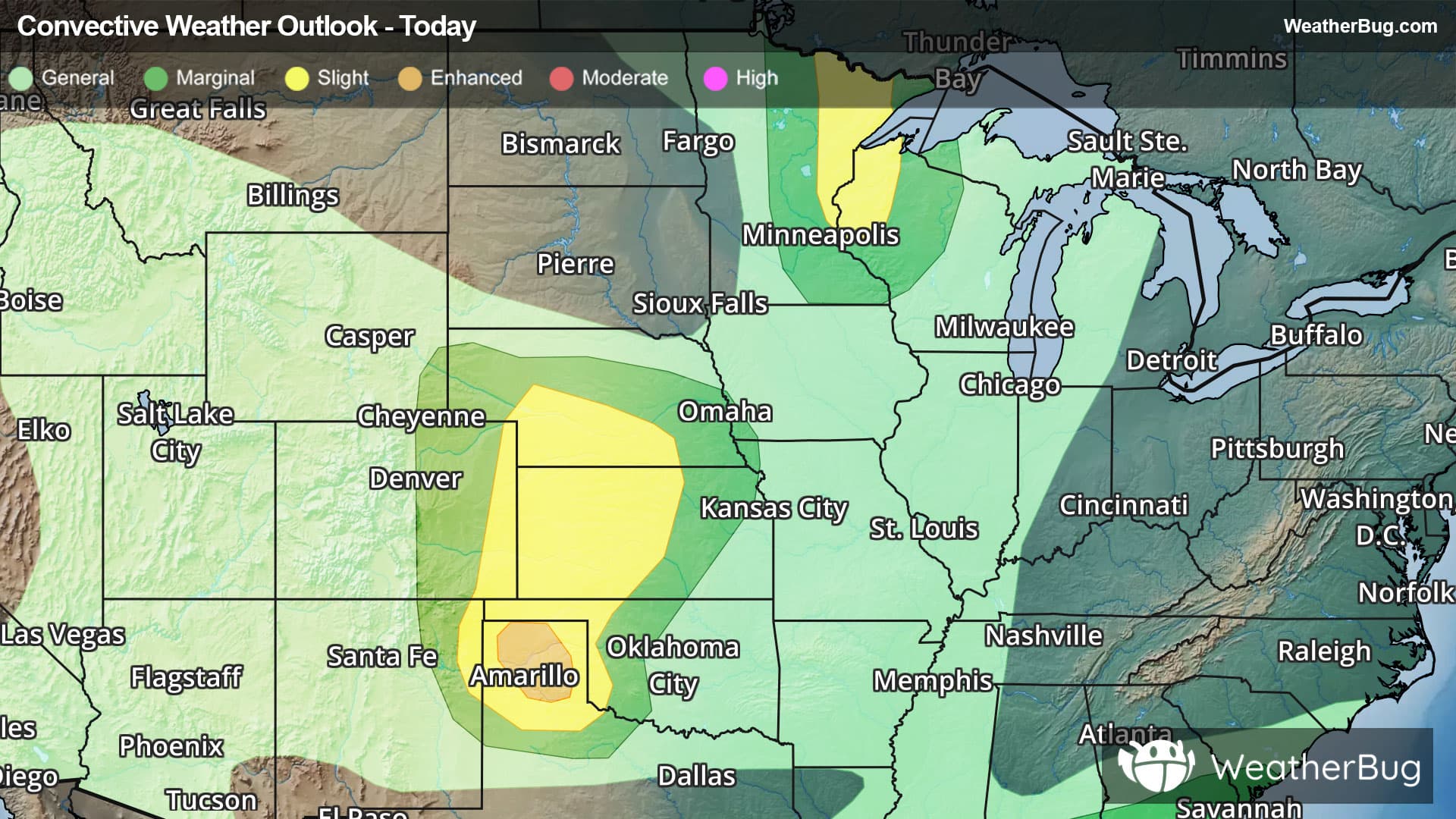
There is a Slight Severe Storm Risk for your location. Continue reading for today's outlook from the National Weather Service's Storm Prediction Center. -------------------- National Severe Storm Outlook THERE IS AN ENHANCED RISK OF SEVERE THUNDERSTORMS FOR THE TEXAS PANHANDLE THERE IS A SLIGHT RISK OF SEVERE THUNDERSTORMS FOR EASTERN MINNESOTA INTO NORTHWEST WISCONSIN AND PORTIONS OF THE CENTRAL AND SOUTHERN HIGH PLAINS SUMMARY Scattered severe thunderstorms are likely across parts of the central/southern Plains this afternoon and evening, and also possible across portions of the Upper Midwest. Severe wind gusts and large hail are the primary hazards. Central High Plains The 15% wind/hail probability areas (and the corresponding Level 2/Slight Risk area) were shifted westward with this outlook update based on the latest HRRR/RRFS and time-lagged ensemble guidance that suggest greater storm coverage is more likely from the southern Nebraska Panhandle into northeastern Colorado, southwestern Nebraska, and northwestern Kansas. The eastern extent of these probabilities was also trimmed across portions of south-central Nebraska and north-central Kansas where recent guidance is more suggestive of lower storm coverage. Elsewhere, the forecast remains generally on track with only minor changes made to the existing outlook. See the discussion below and MCD 2127 for additional details.
Pollen Index: 8.2 Pollen Level: medium-high Predominant Pollen: Grass, Chenopods and Ragweed. The quantity of pollen grains in the air for Wednesday will be falling in the moderate range. This change results in part from falling temperatures, rising humidity, and expected precipitation in the morning and evening which tends to wash pollen out of the air.