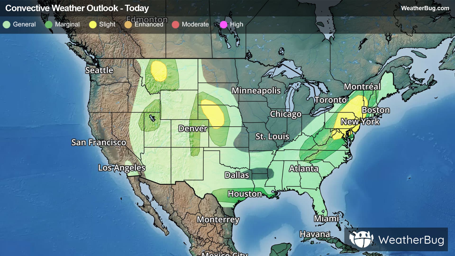
Severe Weather Targets Plains, Mid-Atlantic and Northeast
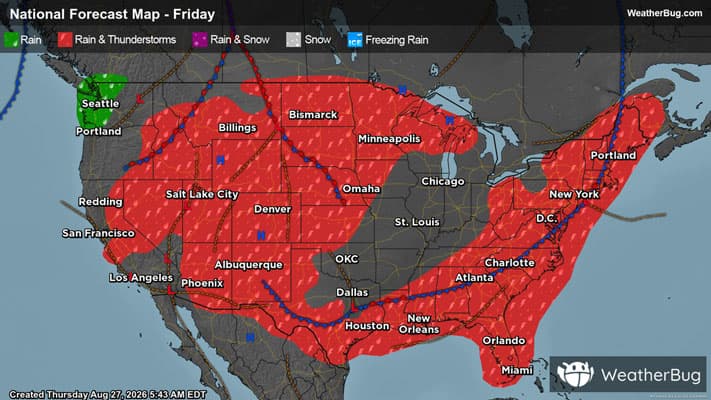
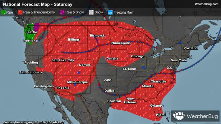
The Mid-Atlantic and portions of the Northeast will need eyes on the sky as severe weather shifts east. Meanwhile, the Plains will get a taste of the action as well.
Read More
# HEADLINE -------------------- FLOOD WATCH REMAINS IN EFFECT UNTIL 4 AM EDT FRIDAY # DETAILS -------------------- WHAT Flash flooding caused by excessive rainfall continues to be possible. WHERE Portions of New Jersey, including the following areas, Hunterdon, Mercer, Middlesex, Morris, Somerset, Sussex and Warren and Pennsylvania, including the following areas, Berks, Delaware, Eastern Chester, Eastern Montgomery, Lehigh, Lower Bucks, Northampton, Philadelphia, Upper Bucks, Western Chester and Western Montgomery. WHEN Until 4 AM EDT Friday. IMPACTS Flooding may occur in poor drainage and urban areas. ADDITIONAL DETAILS - Showers and thunderstorms continue this evening across eastern Pennsylvania and northern New Jersey. Rainfall rates up to 1 to 2 inches per hour remain possible in these storms with already saturated grounds from heavy rain earlier in the day. - http://www.weather.gov/safety/flood ISSUED AT Thursday, August 27, 2026 at 10:52 PM EDT ISSUED BY National Weather Service Mount Holly NJ HEADER Flood Watch # PRECAUTIONARY/PREPAREDNESS ACTIONS -------------------- You should monitor later forecasts and be prepared to take action should Flash Flood Warnings be issued. # AREAS AFFECTED -------------------- Lehigh, Berks, Delaware, Eastern Chester, Eastern Montgomery, Hunterdon, Lower Bucks, Mercer, Middlesex, Morris, Northampton, Philadelphia, Somerset, Sussex, Upper Bucks, Warren, Western Chester, Western Montgomery Including the cities of Somerville, Pottstown, Norristown, Chalfont, Washington, Flemington, Philadelphia, Kennett Square, Lansdale, West Chester, Newton, Doylestown, New Brunswick, Reading, Trenton, Honey Brook, Bethlehem, Media, Morrisville, Easton, Perkasie, Oxford, Collegeville, Allentown, and Morristown
# HEADLINE -------------------- FLOOD WARNING IN EFFECT UNTIL 3 AM EDT FRIDAY REPLACES FLASH FLOOD WARNING # DETAILS -------------------- WHAT Flooding caused by excessive rainfall is expected. WHERE Mercer County in central New Jersey... Southwestern Middlesex County in northern New Jersey... Southwestern Somerset County in northern New Jersey... Southern Hunterdon County in northwestern New Jersey... North Central Burlington County in southern New Jersey... Southeastern Bucks County in southeastern Pennsylvania... Eastern Montgomery County in southeastern Pennsylvania... WHEN Until 300 AM EDT Friday. IMPACTS Flooding of rivers, creeks, streams, and other low-lying and flood-prone locations is imminent or occurring. ADDITIONAL DETAILS - At 807 PM EDT, Doppler radar indicated heavy rain due to thunderstorms. Flooding is ongoing or expected to begin shortly in the warned area. Between 3 and 4 inches of rain have fallen. - Additional rainfall amounts up to 0.5 inches are possible in the warned area. - SOME LOCATIONS THAT WILL EXPERIENCE FLOODING INCLUDE - Trenton, Ewing, Princeton, Bristol, Pennington, Yardley, Newtown, Hopewell, Tullytown and Langhorne. - http://www.weather.gov/safety/flood ISSUED AT Thursday, August 27, 2026 at 8:09 PM EDT ISSUED BY Issued by National Weather Service New York NY HEADER BULLETIN - IMMEDIATE BROADCAST REQUESTED | Flood Warning | National Weather Service Mount Holly NJ # PRECAUTIONARY/PREPAREDNESS ACTIONS -------------------- Turn around, don't drown when encountering flooded roads. Most flood deaths occur in vehicles. Be especially cautious at night when it is harder to recognize the dangers of flooding. # AREAS AFFECTED -------------------- Bucks PA, Burlington NJ, Hunterdon NJ, Mercer NJ, Middlesex NJ, Montgomery PA, Somerset NJ
Closest strike: 19.62 miles Storms Approaching Stay alert and frequently check WeatherBug to see if storms are moving toward you. Be mindful that new storms can also form with little notice.
There is a Marginal Severe Storm Risk for your location. Continue reading for today's outlook from the National Weather Service's Storm Prediction Center. -------------------- National Severe Storm Outlook THERE IS A SLIGHT RISK OF SEVERE THUNDERSTORMS FOR PARTS OF WEST-CENTRAL NE INTO NORTHWEST KS...NORTHERN MID-ATLANTIC...AND WEST-CENTRAL MT SUMMARY Storms capable of producing severe hail and wind remain possible this evening across west-central Nebraska into northwest Kansas. Localized wind damage also remains possible over parts of the Mid-Atlantic and Northeast. Storms with localized severe gusts will continue through the evening across west-central Montana. Central Plains Earlier supercells have congealed into a small southward-moving cluster across northwest NE. Steep lapse rates, strong buoyancy (MLCAPE of 2000-3000 J/kg) and effective shear of 40-50 kt (as observed on the 00Z LBF sounding) within a northwesterly flow regime will continue to support organized storms through the evening. The severe-wind (potentially exceeding 75 mph) threat associated with this small MCS is expected to spread towards parts of southwest NE and northwest KS. Any embedded supercells or discrete cells along the periphery of the cluster will also remain capable of producing large hail, given the favorable thermodynamic environment and relatively elongated hodographs. Longevity of this cluster into late tonight is uncertain, due to increasing MLCINH and generally modest large-scale ascent. Some severe potential could spread as far as west-central/southwest KS before diminishing. Parts of the Mid-Atlantic/Northeast Scattered strong to locally severe storms are ongoing this evening from the northern Mid-Atlantic into parts of the Northeast. While substantial convective overturning has occurred, a corridor of moderate MLCAPE remains in place from northern VA into eastern PA and southeast NE. A short-term threat for locally damaging wind and perhaps marginal hail may continue before storms generally weaken by late evening. See MCD 2157 for more information. West-central MT High-based convection is ongoing early this evening across parts of west-central MT. Weak buoyancy will continue to hamper storm intensity, but the favorable lapse rate environment will continue to support potential for strong to severe gusts. See MCD 2158 for more information. Parts of south-central TX Scattered storms across south-central TX are ongoing near a southward-moving composite outflow. These storms may be capable of producing localized damaging gusts through dusk, before weakening with the onset of nocturnal cooling/stabilization.
Pollen Index: 9.6 Pollen Level: medium-high Predominant Pollen: Ragweed, Nettle and Chenopods. The pollen levels for Friday will remain relatively stable in the high range. This is a result of stable temperatures. The pollen producing plants are delivering a fairly constant level of pollen into the air.