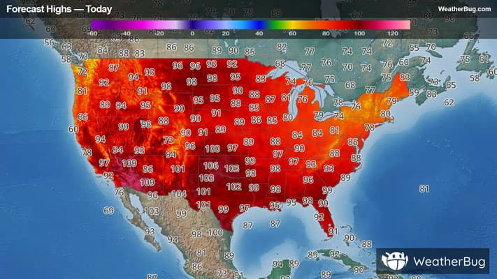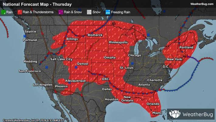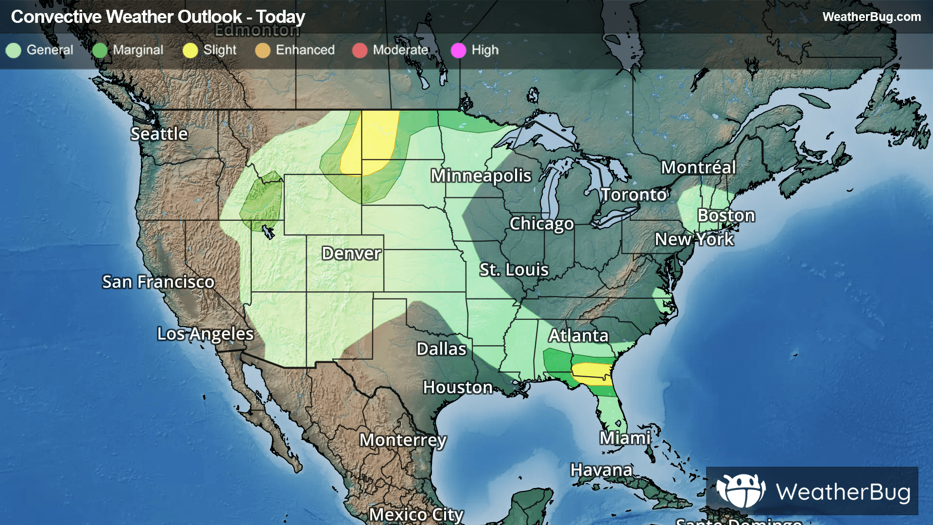
Thunderstorms to Fire Across the Southeast, Northern Plains
Separate regions of severe thunderstorms will impact the Southeast and the northern Plains today.
Read More
# HEADLINE -------------------- FLOOD WATCH REMAINS IN EFFECT UNTIL 8 PM EDT THIS EVENING # DETAILS -------------------- WHAT Flooding caused by excessive rainfall continues to be possible. WHERE The Greater Capital Region, the Lake George Saratoga Region, the northern Taconics including the Rensselaer Plateau, the mid Hudson Valley, eastern Catskills, southern and central Taconics and Helderbergs of eastern New York, Bennington and Windham Counties in southern Vermont, the Berkshires of western Massachusetts, and Litchfield County in northwestern Connecticut. WHEN Until 8 PM EDT this evening. IMPACTS Excessive runoff may result in flooding of rivers, creeks, streams, and other low-lying and flood-prone locations. Flooding may occur in poor drainage and urban areas. ADDITIONAL DETAILS - Periods of moderate to heavy rain and a few thunderstorms continue through this afternoon. Rainfall rates may reach as high as 1 inch per hour within the heaviest and most persistent downpours. - Despite recent dry conditions, such high rainfall rates in a short period of time can result in flash flooding, especially in urban and poor drainage areas and where heavy rain repeatedly impacts a given area. An additional 0.5 to 2 inches of rain is expected for most areas in the flood watch, with locally higher amounts possible of 2-4 inches across the southern Greens, Berkshires and Litchfield County, Connecticut. - Http://www.weather.gov/safety/flood ISSUED AT Wednesday, July 29, 2026 at 3:38 PM EDT ISSUED BY National Weather Service Albany NY HEADER Flood Watch # PRECAUTIONARY/PREPAREDNESS ACTIONS -------------------- You should monitor later forecasts and be alert for possible Flood Warnings. Those living in areas prone to flooding should be prepared to take action should flooding develop. # AREAS AFFECTED -------------------- Southern Berkshire, Bennington, Eastern Albany, Eastern Columbia, Eastern Dutchess, Eastern Greene, Eastern Rensselaer, Eastern Schenectady, Eastern Ulster, Eastern Windham, Northern Berkshire, Northern Litchfield, Northern Saratoga, Northern Warren, Northern Washington, Southeast Warren, Southern Litchfield, Southern Saratoga, Southern Washington, Western Albany, Western Columbia, Western Dutchess, Western Greene, Western Rensselaer, Western Schenectady, Western Ulster, Western Windham Including the cities of Schenectady, Middle Falls, Hancock, Catskill, West Brattleboro, Warrensburg, New Milford, Hunter, Cambridge, Stamford, Florida, North Easton, Sandisfield, West Glens Falls, Arlington, North Creek, Athens, Stanfordville, Saratoga Lake, Brattleboro, North River, Granville, Johnsburg, Woodford State Park, Amenia, Stephentown, Kerhonkson, New Lebanon, North Adams, Berlin, Thomaston, Hudson Falls, New Paltz, Gaylordsville, Sundown, Knox, Hudson, Stratton, Glens Falls, Tannersville, Prattsville, Rotterdam, Pawling, Windham, Guilford Center, Ellenville, Napanoch, Dalton, Burnt Hills, Millbrook, Jefferson Heights, West Shokan, Beacon, Hoosick Falls, Bellows Falls, Ballston Spa, Clifton Park, Berne, Cairo, Huletts Landing, Oakville, Pittsfield, Duanesburg, Kingston, Coxsackie, West Hurley, Pine Plains, Eagle Bridge, Mariaville, Wingdale, Woodstock, Londonderry, Great Barrington, South Egremont, Delanson, Poughkeepsie, Torrington, Pownal, Westerlo, Dover Plains, Whitehall, Hague, Preston Hollow, Greenwich, Albany, Mechanicville, Bennington, Saratoga Springs, Troy, Waterford, Terryville, Bolton Landing, Altamont, and Fort Edward
Closest strike: 2.5 miles Stay Alert! Remain in a safe area until there has been no lightning within 10 miles of this location for 30 minutes. Please be aware that lightning activity can remain high even when a storm is moving away from your location. Even if rain has stopped, do not leave your safe area until WeatherBug indicates that lightning is more than 10 miles away from this selected location. IF OUTDOORS Avoid water, high ground, and open spaces. Avoid all metal objects including electric wires, fences, and machinery. Find a safe area in a building or in a fully enclosed vehicle with the windows completely shut. Unsafe places include underneath canopies, small picnic or rain shelters, convertibles, or near trees. IF INDOORS Avoid water and stay away from doors and windows. Avoid using a hard line telephone. Take off headphones. Turn off, unplug, and stay away from appliances, computers, power tools, and TV sets. Lightning may strike exterior electric and phone lines, inducing shocks to inside equipment.