

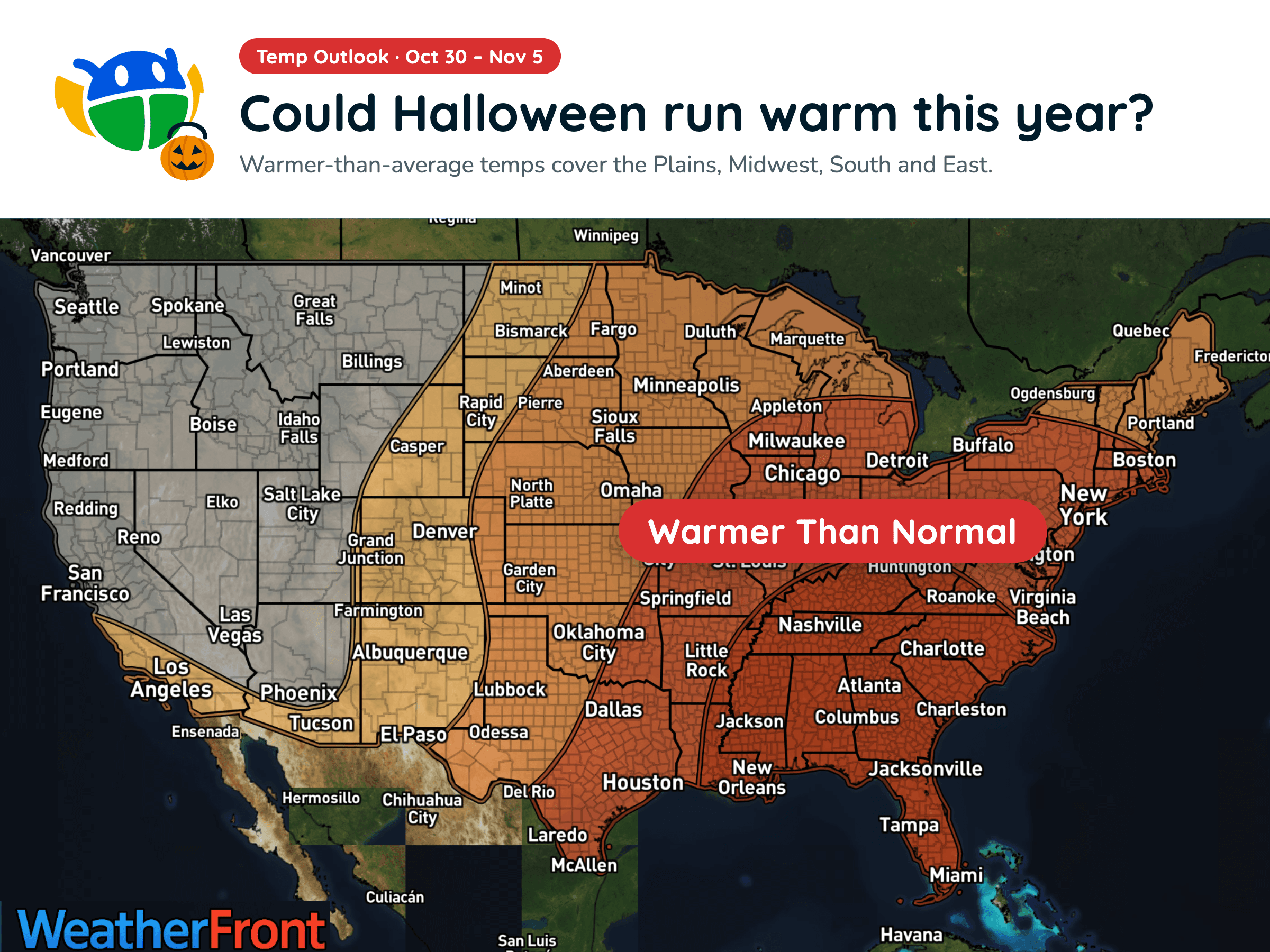
Halloween Weather Outlook: A Warm-Up for Much of the U.S. 🎃
Warmer-than-average temperatures could stick around into early November, but will you need a jacket over your Halloween costume?
Read More
# HEADLINE -------------------- FLOOD WATCH REMAINS IN EFFECT FROM 6 PM MDT THIS EVENING THROUGH LATE TONIGHT # DETAILS -------------------- WHAT Flooding caused by excessive rainfall continues to be possible. WHERE Portions of south central New Mexico, including the following areas, East Central Tularosa Basin/Alamogordo, Otero Mesa, Southeast Tularosa Basin and West Central Tularosa Basin/White Sands and southwest Texas, including the following areas, Eastern/Central El Paso County, Northern Hudspeth Highlands/Hueco Mountains, Rio Grande Valley of Eastern El Paso/Western Hudspeth Counties, Rio Grande Valley of Eastern Hudspeth County, Salt Basin, Southern Hudspeth Highlands and Western El Paso County. WHEN From 6 PM MDT this evening through late tonight. IMPACTS Excessive runoff may result in flooding of rivers, creeks, streams, and other low-lying and flood-prone locations. Flooding may occur in poor drainage and urban areas. Low-water crossings may be flooded. ADDITIONAL DETAILS - Additional showers and thunderstorms are expected late this afternoon and into the evening hours. Rainfall amounts will average a half inch to 1" but localized areas may receive 2-3" and when combined with rainfall from Friday, could result in flash flooding. - http://www.weather.gov/safety/flood ISSUED AT Saturday, October 24, 2026 at 12:44 PM MDT ISSUED BY National Weather Service El Paso Tx/Santa Teresa NM HEADER Flood Watch # PRECAUTIONARY/PREPAREDNESS ACTIONS -------------------- You should monitor later forecasts and be alert for possible Flood Warnings. Those living in areas prone to flooding should be prepared to take action should flooding develop. # AREAS AFFECTED -------------------- Rio Grande Valley of Eastern El Paso/Western Hudspeth Counties, Rio Grande Valley of Eastern Hudspeth County, East Central Tularosa Basin/Alamogordo, Eastern/Central El Paso County, Northern Hudspeth Highlands/Hueco Mountains, Otero Mesa, Salt Basin, Southeast Tularosa Basin, Southern Hudspeth Highlands, West Central Tularosa Basin/White Sands, Western El Paso County Including the cities of Indian Hot Springs, Hueco Tanks, Chaparral, Sierra Blanca, Dell City, Fort Bliss, Cornudas, Tornillo, Tularosa, East and Northeast El Paso, Orogrande, Fort Hancock, Salt Flat, Crow Flats, Holloman AFB, Loma Linda, White Sands Range Headquarters, Fabens, Upper Valley, West El Paso, Downtown El Paso, Alamogordo, White Sands National Park, and Socorro
There is a Slight Severe Storm Risk for your location. Continue reading for today's outlook from the National Weather Service's Storm Prediction Center. -------------------- National Severe Storm Outlook THERE IS A SLIGHT RISK OF SEVERE THUNDERSTORMS THIS AFTERNOON AND EVENING OVER PARTS OF NEW MEXICO AND FAR WEST TX SUMMARY Severe wind/hail and a tornado are possible across portions of New Mexico and far west Texas today. NM/Four Corners/Far West TX Recent satellite imagery continues to show a cyclone centered over the Lower CO River Valley with expansive ridging downstream from the western Gulf through the Upper Great Lakes. A shortwave trough is currently progressing through the southeastern periphery of the Lower CO Valley cyclone over northwestern Mexico. General expectation is for the shortwave trough to continue northeastward today with some loss of amplitude as it moves within the confluent flow between the western CONUS upper low and central/eastern CONUS ridging. Persistence of mostly southwesterly flow aloft will continue to promote showers and thunderstorms from the Four Corners vicinity across NM and into far west TX. The airmass becomes more stable with northern extent but should remain buoyant enough to support continued thunderstorms. More widespread cloud cover is anticipated across northern portions of the region, but filtered daytime heating may result in greater destabilization and attendant risk of a few strong/severe storms capable of hail. Greater buoyancy is expected farther south, where dewpoints will likely be in the upper 50s to low 60s amid afternoon highs in the mid/upper 70s. Moderate to strong deep-layer vertical shear will persist across area as well, supporting the potential for supercells. Additionally, a more southeasterly component to the low-level flow is possible from south-central/southeast NM into far west TX, which could support slower storm motions and a relatively greater potential for hail and tornadoes. Some very large hail greater than 2" in diameter is also more possible here. This region should also experience greater large-scale ascent as the shortwave trough moves through during the late afternoon/early evening. This greater ascent could result in a more linear mode and the potential for a few bowing segments. Overall, there appears to be a relatively greater severe potential from south-central NM into southeast NM and far west TX compared to areas farther north and west.
Warmer-than-average temperatures could stick around into early November, but will you need a jacket over your Halloween costume?







