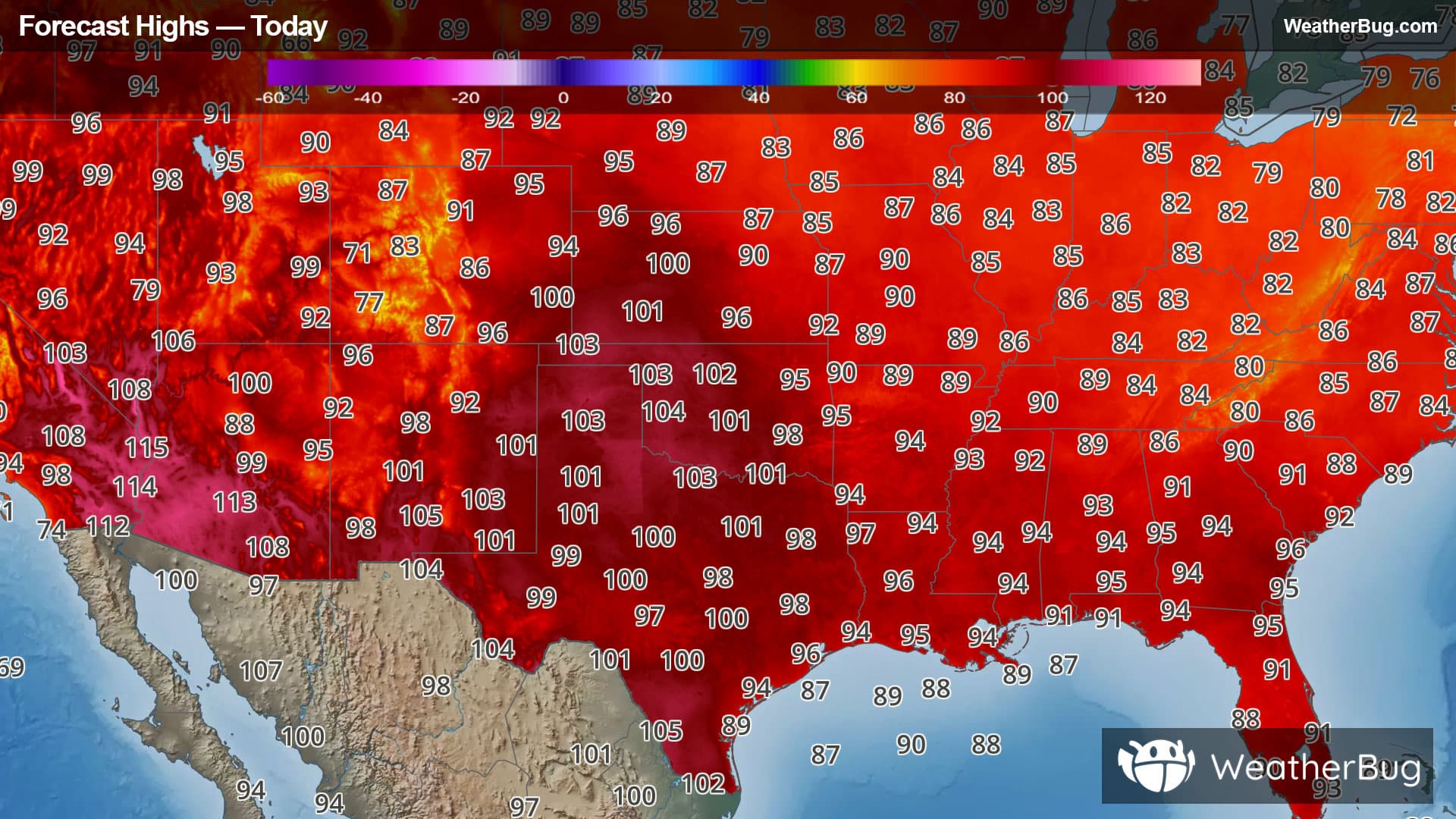
Weather Alerts For Huntsburg, OH
Severe Thunderstorm Watch
-# SUMMARY -------------------- SEVERE THUNDERSTORM WATCH 333 REMAINS IN EFFECT UNTIL 800 PM CDT FOR THE FOLLOWING LOCATIONS OH . OHIO COUNTIES INCLUDED ARE ADAMS ASHTABULA ATHENS BELMONT BROWN CARROLL COLUMBIANA COSHOCTON CUYAHOGA FAIRFIELD GALLIA GEAUGA GUERNSEY HARRISON HIGHLAND HOCKING HOLMES JACKSON JEFFERSON KNOX LAKE LICKING MAHONING MEDINA MEIGS MONROE MORGAN MUSKINGUM NOBLE PERRY PICKAWAY PIKE PORTAGE ROSS SCIOTO STARK SUMMIT TRUMBULL TUSCARAWAS VINTON WASHINGTON WAYNE # DETAILS -------------------- ISSUED AT Sunday, June 14, 2026 at 4:33 PM CDT ISSUED BY NWS STORM PREDICTION CENTER NORMAN OK HEADER SEVERE THUNDERSTORM WATCH OUTLINE UPDATE FOR WS 333
Severe Storm Risk
-There is a Slight Severe Storm Risk for your location. Continue reading for today's outlook from the National Weather Service's Storm Prediction Center. -------------------- National Severe Storm Outlook THERE IS A SLIGHT RISK OF SEVERE THUNDERSTORMS FROM THE MIDDLE OHIO VALLEY INTO THE NORTHEAST...AND ALONG THE SOUTHERN APPALACHIANS INTO THE MID-ATLANTIC SUMMARY Scattered severe thunderstorms capable of damaging wind gusts and some hail are expected this afternoon and evening from the Upper Ohio River Valley into the Northeast, and from the Appalachians into the Mid-Atlantic States. 20z The previous forecast remains on track with only minor adjustments required based on recent convective trends. As of 19:30 UTC, MRMS imagery depicts an intensifying squall line with a history of severe gusts moving eastward across northeast OH. This section of the squall line remains well-phased with ascent and stronger mid-level flow associated with the shortwave trough aloft. Downstream of the squall line, a recent 18 UTC RAOB from PIT sampled a strongly sheared and uncapped environment that should maintain squall line intensity through early evening and lends confidence in the ongoing wind forecast. Further south across the Mid-Atlantic, temperatures continue to warm into the mid 90s with the early stages of organized convection noted along the Appalachians and within a surface trough in north-central NC. Regional 18 UTC soundings sampled a sufficiently buoyant and strongly sheared environment that will likely promote further organization and intensification through the evening hours as convection spreads east/northeast. See MCD #1141 for regional details and the previous discussion below for additional forecast information.