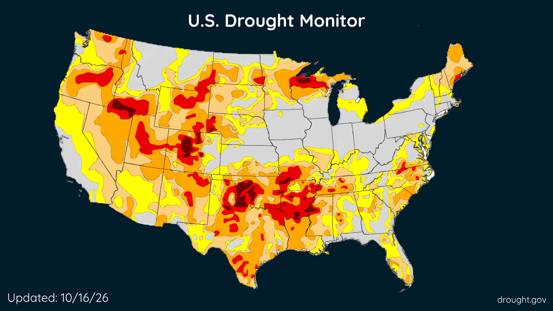
U.S. Drought Improves, Rain Brings Relief, but Some Areas Get Drier
The Southeast and parts of the West made progress this week, while drought deepened across portions of the country’s middle.
Read More
# HEADLINE -------------------- COASTAL FLOOD WARNING REMAINS IN EFFECT FROM 5 PM THIS AFTERNOON TO 4 AM CHST MONDAY HIGH SURF WARNING REMAINS IN EFFECT FROM 5 PM THIS AFTERNOON TO 4 AM CHST MONDAY # SUMMARY -------------------- Guam-Rota-Tinian-Saipan- 1025 AM ChST Sat Oct 17 2026 # DETAILS -------------------- WHAT For the Coastal Flood Warning, significant coastal flooding expected. For the High Surf Warning, dangerously large breaking waves up to 35 feet for Guam, 20 to 25 feet for Rota, and 15 to 20 feet for Tinian and Saipan. WHERE Guam, Rota, Tinian and Saipan. WHEN From 5 PM this afternoon to 4 AM ChST Monday. IMPACTS Numerous roads may be closed. Low-lying property including homes, businesses, and some critical infrastructure will be inundated. Shoreline erosion will occur. Breaking waves can sweep people off their feet, and into dangerous seas. Life- threatening swimming conditions and significant beach erosion can be expected. Coastal inundation of 5 to 7 feet for Guam, 2 to 4 feet for Rota and 1 to 3 feet for Tinian and Saipan is possible along with coastal flooding and beach erosion. ADDITIONAL DETAILS Surf is expected to rise rapidly to dangerous levels tonight. Coastal impacts to the western coast of Guam and Rota are highly dependent on the final track of Champi; passage south of Guam would be reduced impacts whereas passage over Guam would result in larger coastal inundation. ISSUED AT Saturday, October 17, 2026 at 10:25 AM CHST ISSUED BY National Weather Service Tiyan GU HEADER URGENT - IMMEDIATE BROADCAST REQUESTED | Coastal Hazard Message # PRECAUTIONARY/PREPAREDNESS ACTIONS -------------------- Everyone should remain out of the water due to life-threatening surf conditions. Stay well away from the coast.
# HEADLINE -------------------- COASTAL FLOOD WARNING REMAINS IN EFFECT FROM 5 PM THIS AFTERNOON TO 4 AM CHST MONDAY HIGH SURF WARNING REMAINS IN EFFECT FROM 5 PM THIS AFTERNOON TO 4 AM CHST MONDAY # SUMMARY -------------------- Guam-Rota-Tinian-Saipan- 1025 AM ChST Sat Oct 17 2026 # DETAILS -------------------- WHAT For the Coastal Flood Warning, significant coastal flooding expected. For the High Surf Warning, dangerously large breaking waves up to 35 feet for Guam, 20 to 25 feet for Rota, and 15 to 20 feet for Tinian and Saipan. WHERE Guam, Rota, Tinian and Saipan. WHEN From 5 PM this afternoon to 4 AM ChST Monday. IMPACTS Numerous roads may be closed. Low-lying property including homes, businesses, and some critical infrastructure will be inundated. Shoreline erosion will occur. Breaking waves can sweep people off their feet, and into dangerous seas. Life- threatening swimming conditions and significant beach erosion can be expected. Coastal inundation of 5 to 7 feet for Guam, 2 to 4 feet for Rota and 1 to 3 feet for Tinian and Saipan is possible along with coastal flooding and beach erosion. ADDITIONAL DETAILS Surf is expected to rise rapidly to dangerous levels tonight. Coastal impacts to the western coast of Guam and Rota are highly dependent on the final track of Champi; passage south of Guam would be reduced impacts whereas passage over Guam would result in larger coastal inundation. ISSUED AT Saturday, October 17, 2026 at 10:25 AM CHST ISSUED BY National Weather Service Tiyan GU HEADER URGENT - IMMEDIATE BROADCAST REQUESTED | Coastal Hazard Message # PRECAUTIONARY/PREPAREDNESS ACTIONS -------------------- Everyone should remain out of the water due to life-threatening surf conditions. Stay well away from the coast.
# HEADLINE -------------------- TYPHOON CHAMPI MOVING WEST-NORTHWEST TOWARDS GUAM TYPHOON WARNING REMAINS IN EFFECT # SUMMARY -------------------- Extremely dangerous winds will cause extensive damage. Structural collapse of some homes could cause severe injuries or possible death. Persons struck by airborne debris risk injury and possible death. Most metal roof homes will be destroyed. Some container homes will be destroyed or severely damaged, leaving them uninhabitable. Considerable damage to well constructed homes is expected. A number of roofs and exterior walls will fail. Many metal roofs will be torn off buildings at industrial parks. Partial roof and exterior wall failures are likely at low rise apartment buildings. Many windows in high rise buildings will be blown out. Falling and broken glass will pose a significant danger even after the storm. Near total power loss is expected. Potable water could become scarce as filtration systems begin to fail. Many trees will be snapped or uprooted and block numerous roads. # DETAILS -------------------- ISSUED AT Saturday, October 17, 2026 at 9:13 AM CHST ISSUED BY National Weather Service Tiyan GU HEADER URGENT - IMMEDIATE BROADCAST REQUESTED | Typhoon Champi (29W) Local Statement # PRECAUTIONARY/PREPAREDNESS ACTIONS -------------------- For those under a Typhoon Warning, preparations should have already been completed or should be completed very soon. Remain in a sturdy shelter until local officials give the all clear. For those under a Tropical Storm Warning, preparations according to your typhoon disaster plan shall be completed as soon as possible for your home or business. Heed the advice of local officials and comply with any orders that are issued. For those under a Typhoon Watch, now is the time to begin preparing your home or business according to your typhoon disaster plan. Listen for possible warnings and be ready to evacuate if necessary. Heed the advice of local officials and comply with any orders that are issued. For interests at ports, docks, and marinas, it is recommended that you perform the prescribed preparations according to your emergency operations plan for tropical cyclones. If you live on a boat, begin to safely secure your craft and make plans to leave it for adequate land based shelter. Listen for possible warnings. Be aware of the latest port conditions from the local port authority and from the United States Coast Guard. Regarding the coastal waters under a Watch, small craft should return to port or seek safe harbor. Closely monitor NOAA weather radio or other local news outlets for official storm information. Listen for possible changes to the forecast. For additional precautionary and preparedness information, please refer to the detailed recommendations relative to your location as further described by your local National Weather Service office, and your local emergency management. .NEXT UPDATE... The next local statement will be issued by the National Weather Service in Tiyan, Guam around 3 PM ChST or sooner, if conditions warrant. Guam- 913 AM ChST Sat Oct 17 2026 ...
# HEADLINE -------------------- FLOOD WATCH REMAINS IN EFFECT THROUGH SUNDAY AFTERNOON # SUMMARY -------------------- Guam-Rota-Tinian-Saipan- 501 AM ChST Sat Oct 17 2026 # DETAILS -------------------- WHAT Flooding caused by excessive rainfall continues to be possible. WHERE Guam, Rota, Saipan and Tinian. WHEN Through Sunday afternoon. IMPACTS Excessive runoff may result in flooding of rivers, creeks, streams, and other low-lying and flood-prone locations. Flooding may occur in poor drainage and urban areas. Storm drains and ditches may become clogged with debris. Extensive street flooding and flooding of creeks and rivers are possible. - TROPICAL STORM CHAMPI (29W) WILL DROP COPIOUS AMOUNTS OF RAIN OVER SUNDAY AND MONDAY - although an unexpected southward shift in track will reduce these somewhat. Tinian and Saipan will see around 4 to 6 inches, Rota could receive 10 to 15 inches, and Guam might get 12 to 20 inches. - http://www.weather.gov/safety/flood ISSUED AT Saturday, October 17, 2026 at 5:01 AM CHST ISSUED BY National Weather Service Tiyan GU HEADER Flood Watch # PRECAUTIONARY/PREPAREDNESS ACTIONS -------------------- You should monitor later forecasts and be prepared to take action should Flash Flood Warnings be issued.
The Southeast and parts of the West made progress this week, while drought deepened across portions of the country’s middle.