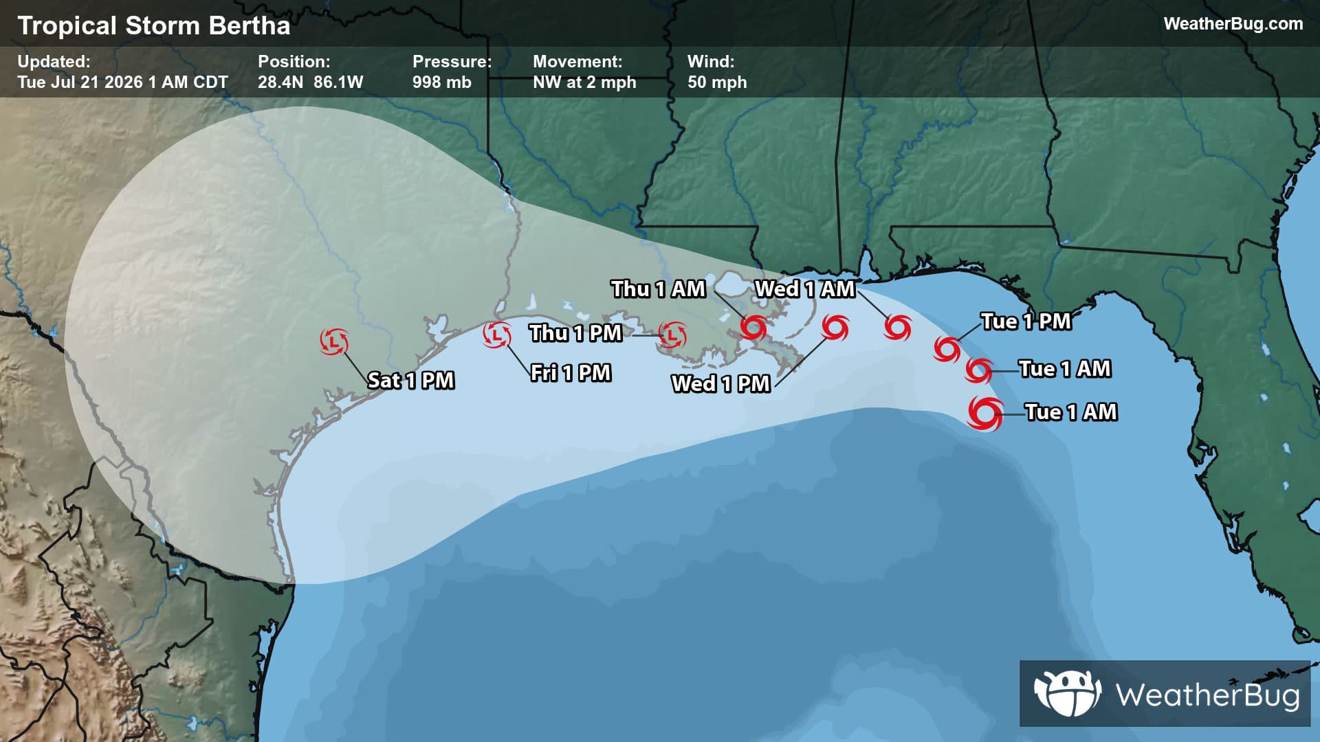
Tropical Storm Bertha Crawls Along Gulf Coast
Tropical Storm Bertha is the Atlantic's second named storm of the season.
Read More
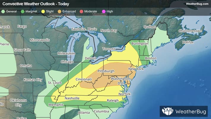
# HEADLINE -------------------- FLOOD WATCH IN EFFECT FROM 1 PM EDT THIS AFTERNOON THROUGH LATE TONIGHT # DETAILS -------------------- WHAT Flash flooding caused by excessive rainfall is possible. WHERE Portions of northeast Kentucky, including the following counties, Boyd, Carter, Greenup and Lawrence, southeast Ohio, including the following counties, Athens, Gallia, Jackson OH, Lawrence OH, Meigs, Morgan, Vinton and Washington, southwest Virginia, including the following counties, Buchanan and Dickenson, and West Virginia, including the following counties, Barbour, Boone, Braxton, Cabell, Calhoun, Clay, Doddridge, Gilmer, Harrison, Jackson WV, Kanawha, Lewis, Lincoln, Logan, Mason, McDowell, Mingo, Northwest Fayette, Northwest Nicholas, Northwest Pocahontas, Northwest Raleigh, Northwest Randolph, Northwest Webster, Pleasants, Putnam, Ritchie, Roane, Southeast Fayette, Southeast Nicholas, Southeast Raleigh, Southeast Randolph, Southeast Webster, Taylor, Tyler, Upshur, Wayne, Wirt, Wood and Wyoming. WHEN From 1 PM EDT this afternoon through late tonight. IMPACTS Excessive runoff may result in flooding of rivers, creeks, streams, and other low-lying and flood-prone locations. Flooding may occur in poor drainage and urban areas. Low-water crossings may be flooded. Storm drains and ditches may become clogged with debris. ADDITIONAL DETAILS - Training or backbuilding thunderstorms this afternoon into tonight could create swaths of heavy rain, resulting in rainfall totals of 2 to 4 inches. - http://www.weather.gov/safety/flood ISSUED AT Tuesday, July 21, 2026 at 3:59 AM EDT ISSUED BY National Weather Service Charleston WV HEADER URGENT - IMMEDIATE BROADCAST REQUESTED | Flood Watch # PRECAUTIONARY/PREPAREDNESS ACTIONS -------------------- You should monitor later forecasts and be prepared to take action should Flash Flood Warnings be issued. Additional information can be found at https://www.weather.gov/rlx as well as on our X and Facebook pages. # AREAS AFFECTED -------------------- Gilmer, Mason, Northwest Raleigh, Northwest Randolph, Northwest Webster, Roane, Southeast Fayette, Vinton, Athens, Barbour, Boone, Boyd, Braxton, Buchanan, Cabell, Calhoun, Carter, Clay, Dickenson, Doddridge, Gallia, Greenup, Harrison, Jackson OH, Jackson WV, Kanawha, Lawrence, Lawrence OH, Lewis, Lincoln, Logan, McDowell, Meigs, Mingo, Morgan, Northwest Fayette, Northwest Nicholas, Northwest Pocahontas, Pleasants, Putnam, Ritchie, Southeast Nicholas, Southeast Raleigh, Southeast Randolph, Southeast Webster, Taylor, Tyler, Upshur, Washington, Wayne, Wirt, Wood, Wyoming Including the cities of War, Sutton, Ceredo, Ironton, Harrisville, Hurricane, Sophia, Belpre, Parkersburg, Jackson, Mullens, Alum Creek, Grayson, West Union, South Charleston, Harman, Paden City, Grundy, St. Marys, Lake Vesuvius, Holly River State Park, South Point, Athens, McConnelsville, McArthur, Kenova, Welch, Grayson Lake State Park, Pomeroy, Clarksburg, Olive Hill, Fayetteville, Harts, Marietta, New Haven, Beckley, Grantsville, Gallipolis, Raceland, Snowshoe, Stockport, Louisa, Breaks Interstate Park, Clintwood, Russell, Charleston, Carter Caves State Park, Oak Hill, Pennsboro, Hurley, Pineville, Point Pleasant, Weston, Vienna, Richwood, Craigsville, Cowen, Elkins, Montgomery, Birch River, Chapmanville, Huntington, Prosperity, Ashland, Hamlin, Logan, Madison, Burnsville, Ripley, Williamson, Teays Valley, Bridgeport, Saint Albans, Summersville, Bradley, Philippi, Oceana, Wayne, Sistersville, Spencer, Middlebourne, Webster Springs, Yatesville Lake State Park, Grafton, Meadow Bridge, Wellston, Glenville, Gary, Elizabeth, Clay, Buckhannon, Belington, Cannonsburg, Vansant, Davenport, Flatwoods, Hamden, Ravenswood, Belmont, Gassaway, and Man
Closest strike: 0.88 miles Stay Alert! Remain in a safe area until there has been no lightning within 10 miles of this location for 30 minutes. Please be aware that lightning activity can remain high even when a storm is moving away from your location. Even if rain has stopped, do not leave your safe area until WeatherBug indicates that lightning is more than 10 miles away from this selected location. IF OUTDOORS Avoid water, high ground, and open spaces. Avoid all metal objects including electric wires, fences, and machinery. Find a safe area in a building or in a fully enclosed vehicle with the windows completely shut. Unsafe places include underneath canopies, small picnic or rain shelters, convertibles, or near trees. IF INDOORS Avoid water and stay away from doors and windows. Avoid using a hard line telephone. Take off headphones. Turn off, unplug, and stay away from appliances, computers, power tools, and TV sets. Lightning may strike exterior electric and phone lines, inducing shocks to inside equipment.