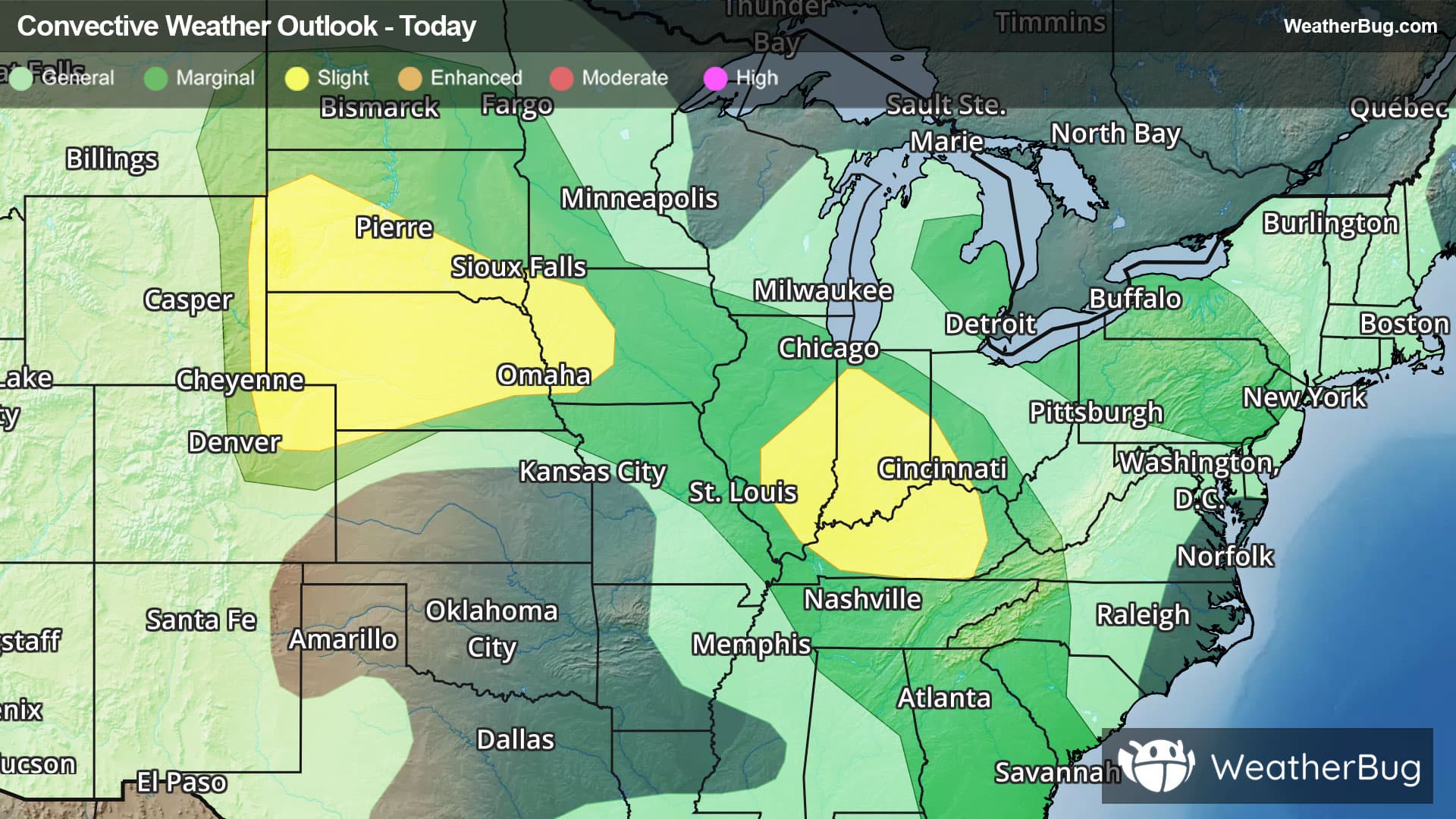
Severe Weather Takes Aim At High Plains to Ohio Valley
The ongoing outbreak of severe storms continues today, shifting southward into the central Plains and Lower Ohio Valley.
Read More
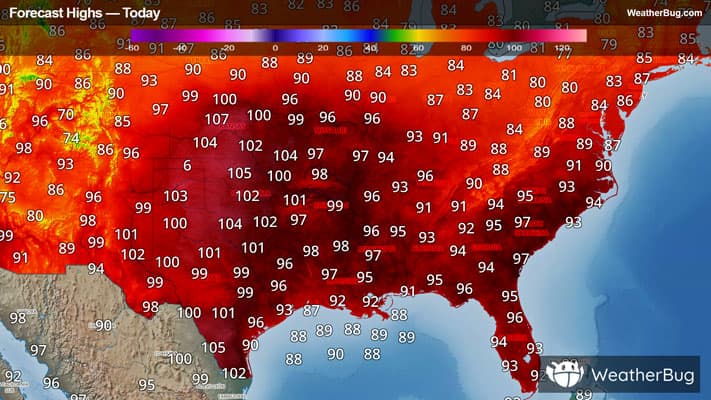
# HEADLINE -------------------- HEAT ADVISORY NOW IN EFFECT UNTIL 7 PM CDT SUNDAY # DETAILS -------------------- WHAT Heat index values up to 109. WHERE A portion of Middle Tennessee. WHEN Until 7 PM CDT Sunday. IMPACTS Hot temperatures and high humidity may cause heat illnesses. ISSUED AT Wednesday, August 12, 2026 at 11:18 AM CDT ISSUED BY National Weather Service Nashville TN HEADER URGENT - WEATHER MESSAGE # PRECAUTIONARY/PREPAREDNESS ACTIONS -------------------- Drink plenty of fluids, stay in an air-conditioned room, stay out of the sun, and check up on relatives and neighbors. Take extra precautions when outside. Wear lightweight and loose fitting clothing. Try to limit strenuous activities to early morning or evening. Take action when you see symptoms of heat exhaustion and heat stroke. # AREAS AFFECTED -------------------- Cheatham, Lawrence, Williamson, Bedford, Cannon, Coffee, Davidson, Dickson, Giles, Hickman, Houston, Humphreys, Lewis, Macon, Marshall, Maury, Montgomery, Perry, Robertson, Rutherford, Smith, Stewart, Sumner, Trousdale, Wayne, Wilson Including the cities of Lewisburg, Carthage, Dover, Gallatin, Tullahoma, Centerville, Ashland City, Erin, Dickson, Smyrna, Pulaski, Waverly, Waynesboro, Hendersonville, Lebanon, Tennessee Ridge, Manchester, Springfield, Linden, Hohenwald, Goodlettsville, Lafayette, South Carthage, Columbia, Murfreesboro, Lawrenceburg, Clarksville, Nashville, Shelbyville, Clifton, Kingston Springs, La Vergne, New Johnsonville, Gordonsville, McEwen, Mount Juliet, Woodbury, Franklin, Brentwood, Hartsville, and Lobelville
Closest strike: 23.64 miles Monitor Storms You are not at immediate risk, but frequently check WeatherBug to see if storms are moving towards you. Be aware that new storms can also form with little notice.
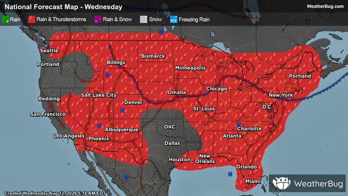
There is a Marginal Severe Storm Risk for your location. Continue reading for today's outlook from the National Weather Service's Storm Prediction Center. -------------------- National Severe Storm Outlook THERE IS A SLIGHT RISK OF SEVERE THUNDERSTORMS FROM ILLINOIS TO KENTUCKY AND FROM THE NORTHERN HIGH PLAINS TO THE MID MISSOURI VALLEY SUMMARY Scattered severe thunderstorms with occasional wind damage are possible this afternoon/evening from Illinois/Indiana into Kentucky. Initial supercells with very large hail will be possible this afternoon/evening across the central/northern High Plains. The storms are expected to evolve into a cluster or two overnight while spreading eastward across Nebraska/South Dakota with the potential for severe outflow gusts. OH Valley area through this evening An MCS is ongoing across northern IL with the primary cold pool surge and bowing segment progressing from northeast IL into northwest IN. Elevated convection is ongoing in the zone of warm advection atop the cold pool in IN. This elevated convection will pose a threat for isolated large hail into this afternoon, while a feed of steeper midlevel lapse rates and low-level moisture from the west will help maintain the IL/IN MCS into this afternoon with a continued threat for occasional wind damage with gusts of 60-75 mph. The eastern extent of the severe threat into OH is uncertain given the ongoing/elevated convection and limited recovery time. Thus, the eastward extent of any wind threat associated with the ongoing IL/IN MCS is likewise uncertain. Additional thunderstorm development is possible this afternoon along the trailing outflow from central IL into southern IN and KY, where occasional wind damage will be possible into this evening. Northern Plains this afternoon through tonight A subtle midlevel speed max over southwest WY will progress eastward around the northwest periphery of the southern Plains ridge. Weak ascent preceding this wave, in combination with surface heating in cloud breaks and low-level upslope flow with boundary-layer dewpoints in the 60s, will support scattered afternoon/evening thunderstorm development from northeast CO into western SD. Lingering steep midlevel lapse rates on the fringe of the monsoonal moisture plume in WY and effective bulk shear near or above 40 kt (with long hodographs aloft) will favor supercells initially with the potential for very large hail (2-3 inches in diameter). There will likely be some upscale growth into a cluster or two this evening into tonight on the nose of a 30-40 kt low-level jet across NE/SD, with a transition to severe outflow gusts of 65-80 mph as the main threat. The storm cluster(s) will likely reach western IA early Thursday morning. Lower MI into western NY/PA through late evening Subtle speed maxima will move east-southeastward from Lower MI to NY/PA through this evening. Midlevel lapse rates of 6-7 C/km and boundary-layer dewpoints in the mid 60s will support MLCAPE near or above 1000 J/kg, in an environment with sufficient deep-layer shear/hodograph length for storms with supercell structures. Isolated large hail and wind damage will be the main threats, though a more discrete mode would be less favorable for wind damage, and storm coverage could remain somewhat isolated. Thus, will maintain a MRGL risk, though there was some consideration for an upgrade to SLGT across western NY and vicinity. South GA/north FL this afternoon Scattered thunderstorm development appears probable from south GA into north FL this afternoon along a subtle confluence zone with large buoyancy immediately southwest of a remnant MCV over southeast GA. A few multicell clusters will be capable of producing isolated strong outflow gusts/wind damage with downbursts.
Pollen Index: 8.4 Pollen Level: medium-high Predominant Pollen: Grass. The quantity of pollen grains in the air for Thursday will be falling but will remain in the high range. This decrease is due to falling temperatures, rising relative humidity and weaker winds.