

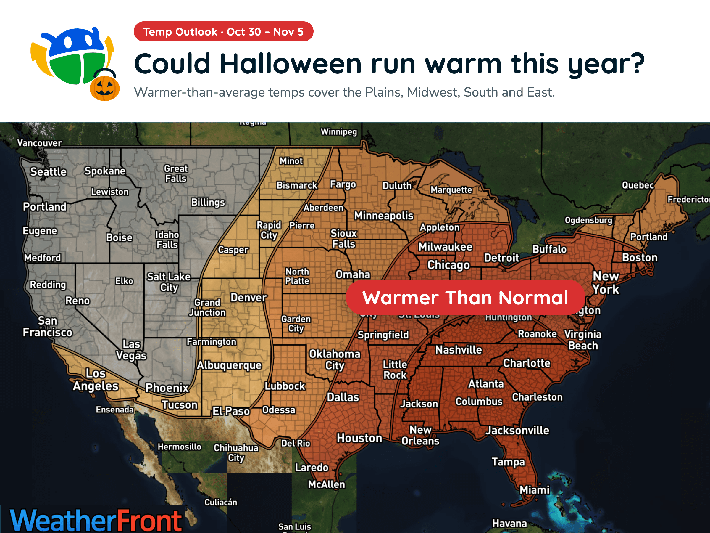
Halloween Weather Outlook: A Warm-Up for Much of the U.S. 🎃
Warmer-than-average temperatures could stick around into early November, but will you need a jacket over your Halloween costume?
Read More
# HEADLINE -------------------- FLOOD WARNING REMAINS IN EFFECT UNTIL 9 AM MDT MONDAY # DETAILS -------------------- WHAT Flooding caused by excessive rainfall is ongoing. WHERE Western Montezuma County in southwestern Colorado... Southern San Juan County in southeastern Utah... WHEN Until 900 AM MDT Monday. IMPACTS Flooding along San Juan River is occurring. Low-water crossing are inundated with water and may not be passable. The river is running fast and high. Do not attempt to cross. ADDITIONAL DETAILS - At 407 PM MDT, The San Juan River is forecast to crest Sunday morning between the Four Corners and Bluff, cresting between Bluff and Mexican Hat Sunday afternoon and peaking at Mexican Hat by midnight Sunday night. - THIS INCLUDES THE FOLLOWING STREAMS AND DRAINAGES San Juan River - SOME LOCATIONS THAT WILL EXPERIENCE FLOODING INCLUDE - Mexican Hat, Tselakai Dezza, Bluff, Halchita, Montezuma Creek and Aneth. - http://www.weather.gov/safety/flood ISSUED AT Saturday, October 24, 2026 at 4:20 PM MDT ISSUED BY National Weather Service Grand Junction CO HEADER Flood Statement # PRECAUTIONARY/PREPAREDNESS ACTIONS -------------------- Turn around, don't drown when encountering flooded roads. Most flood deaths occur in vehicles. Stay away or be swept away. River banks and culverts can become unstable and unsafe. # AREAS AFFECTED -------------------- Montezuma CO, San Juan UT
# HEADLINE -------------------- FLOOD WATCH REMAINS IN EFFECT THROUGH SUNDAY MORNING # DETAILS -------------------- WHAT Flooding caused by excessive rainfall continues to be possible. WHERE Portions of southwest Colorado, including the following areas, Animas River Basin, Four Corners/Upper Dolores River, San Juan River Basin and Southwest San Juan Mountains and Utah, including the following areas, Arches/Grand Flat, Canyonlands/Natural Bridges, La Sal and Abajo Mountains and Southeast Utah. WHEN Through Sunday morning. IMPACTS Excessive runoff may result in flooding of rivers, creeks, streams, recent burn scars and other low-lying and flood-prone locations. Low-water crossings may be flooded. Storm drains and ditches may become clogged with debris. ADDITIONAL DETAILS - Flooding is imminent or ongoing with additional rounds of showers and thunderstorms expected through Saturday afternoon. Rivers and creeks may still experience high waters even after rainfall has ended. - http://www.weather.gov/safety/flood ISSUED AT Saturday, October 24, 2026 at 11:39 AM MDT ISSUED BY National Weather Service Grand Junction CO HEADER Flood Watch # PRECAUTIONARY/PREPAREDNESS ACTIONS -------------------- You should monitor later forecasts and be alert for possible Flood Warnings. Those living in areas prone to flooding should be prepared to take action should flooding develop. # AREAS AFFECTED -------------------- San Juan River Basin, Animas River Basin, Arches/Grand Flat, Canyonlands/Natural Bridges, Four Corners/Upper Dolores River, La Sal and Abajo Mountains, Northwest San Juan Mountains, Paradox Valley/Lower Dolores River, Southeast Utah, Southwest San Juan Mountains, Uncompahgre Plateau and Dallas Divide Including the cities of Ridgway, Loghill Village, Telluride, Mountain Village, Ouray, Lake City, Sawpit, Pagosa Springs, Silverton, Rico, Nucla, Naturita, Norwood, Slick Rock, Cortez, Mancos, Dolores, Dove Creek, Durango, Bayfield, Ignacio, Blanding, Oljato-Monument Valley, Goulding, Bluff, Tselakai Dezza, Aneth, Montezuma Creek, Mexican Hat, Halchita, White Mesa, Moab, Green River, Castle Valley, Monticello, La Sal, Eastland, Spanish Valley, Fry Canyon, and Canyonlands National Park
Closest strike: 16.83 miles Storms Approaching Stay alert and frequently check WeatherBug to see if storms are moving toward you. Be mindful that new storms can also form with little notice.
There is a Marginal Severe Storm Risk for your location. Continue reading for today's outlook from the National Weather Service's Storm Prediction Center. -------------------- National Severe Storm Outlook THERE IS A SLIGHT RISK OF SEVERE THUNDERSTORMS THIS AFTERNOON AND EVENING OVER PARTS OF NEW MEXICO AND FAR WEST TX SUMMARY Severe wind/hail and a tornado are possible across portions of New Mexico and far west Texas today. 20z Update Only minor adjustments were made to the existing severe probabilities as the forecast remains generally on track. See the prior discussion below for additional details. Elsewhere, the General Thunder area was trimmed across portions of the northern Plains/upper Midwest in the wake of the passage of a surface cold front and accompanying precipitation.
Warmer-than-average temperatures could stick around into early November, but will you need a jacket over your Halloween costume?







