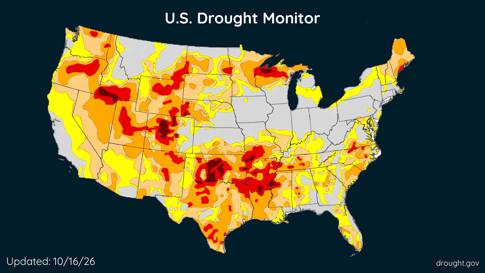
U.S. Drought Improves, Rain Brings Relief, but Some Areas Get Drier
The Southeast and parts of the West made progress this week, while drought deepened across portions of the country’s middle.
Read More
# HEADLINE -------------------- CRITICAL FIRE WEATHER CONDITIONS POSSIBLE TODAY RED FLAG WARNING REMAINS IN EFFECT FROM 9 AM THIS MORNING TO 8 PM CDT THIS EVENING FOR ALL SOUTHERN MISSISSIPPI AND PORTIONS OF SOUTHEAST LOUISIANA # SUMMARY -------------------- .A cold front is introducing some very dry air with RH values falling into the low to mid 30s along with windy conditions with some gusts well into the 30 mph range. Winds are expected to continue in the mid 20 mph range today. The combination of gusty winds, current drought conditions, ample dry fuel, and very dry conditions will allow any fire that develops to spread quickly. A Red Flag Warnings will continue for a large portion of the area today. This headline will drop by Sunday, but only the wind speeds will cause this change. The dry, breezy conditions will remain causing favorable conditions for fire spread. # DETAILS -------------------- AFFECTED AREA Pointe Coupee, West Feliciana, East Feliciana, St. Helena, Washington, Iberville, West Baton Rouge, East Baton Rouge, Assumption, St. James, Wilkinson, Amite, Pike, Northern Tangipahoa, Walthall, Southeast St. Tammany, Pearl River, Northern St. Tammany, Southwestern St. Tammany, Hancock, Central Tangipahoa, Harrison, Lower Tangipahoa, Jackson, Northern Livingston, Southern Livingston, Western Ascension and Eastern Ascension. WINDS North 15 to 20 mph with gusts up to 30 mph. RELATIVE HUMIDITY As low as 30 percent. IMPACTS Any fire that develops will catch and spread quickly. Outdoor burning is not recommended. ISSUED AT Saturday, October 17, 2026 at 3:27 AM CDT ISSUED BY National Weather Service New Orleans LA HEADER URGENT - FIRE WEATHER MESSAGE # PRECAUTIONARY/PREPAREDNESS ACTIONS -------------------- A Red Flag Warning means that critical fire weather conditions are either occurring now, or will shortly. A combination of strong winds, low relative humidity, and warm temperatures can contribute to extreme fire behavior. # AREAS AFFECTED -------------------- Eastern Ascension, Hancock, Iberville, Northern Livingston, Northern Tangipahoa, Southwestern St. Tammany, Amite, Assumption, Central Tangipahoa, East Baton Rouge, East Feliciana, Harrison, Jackson, Lower Tangipahoa, Northern St. Tammany, Pearl River, Pike, Pointe Coupee, Southeast St. Tammany, Southern Livingston, St. Helena, St. James, Walthall, Washington, West Baton Rouge, West Feliciana, Western Ascension, Wilkinson
# HEADLINE -------------------- WIND ADVISORY REMAINS IN EFFECT UNTIL 3 PM CDT THIS AFTERNOON # DETAILS -------------------- WHAT North winds 15 to 25 mph with gusts up to 35 mph. WHERE Portions of southeast Louisiana and southern Mississippi. WHEN Until 3 PM CDT this afternoon. IMPACTS Gusty winds will blow around unsecured objects. Tree limbs could be blown down and a few power outages may result. ISSUED AT Saturday, October 17, 2026 at 3:29 AM CDT ISSUED BY National Weather Service New Orleans LA HEADER URGENT - WEATHER MESSAGE # PRECAUTIONARY/PREPAREDNESS ACTIONS -------------------- Winds this strong can make driving difficult, especially for high profile vehicles. Use extra caution. Secure outdoor objects. # AREAS AFFECTED -------------------- Central Plaquemines, Iberville, Lower Tangipahoa, Northern St. Tammany, Southern Harrison, St. John The Baptist, Amite, Assumption, Central Jefferson, Central St. Charles, Central Tangipahoa, Coastal Jefferson, East Baton Rouge, East Feliciana, Eastern Ascension, Eastern Orleans, Lower Lafourche, Lower Plaquemines, Lower St. Bernard, Lower St. Charles, Lower Terrebonne, Northern Hancock, Northern Harrison, Northern Jackson, Northern Livingston, Northern Tangipahoa, Pearl River, Pike, Pointe Coupee, Southeast St. Tammany, Southern Hancock, Southern Jackson, Southern Livingston, Southwestern St. Tammany, St. Helena, St. James, Upper Jefferson, Upper Lafourche, Upper Plaquemines, Upper St. Bernard, Upper St. Charles, Upper Terrebonne, Walthall, Washington, West Baton Rouge, West Feliciana, Western Ascension, Western Orleans, Wilkinson Including the cities of Grand Isle, Bogalusa, Bayou Sorrel, Easleyville, Necaise, Lyman, Mandeville, Violet, Boutte, Darlington, Dexter, Braithwaite, Bush, Kiln, Folsom, Slidell, Sorrento, St. Martin, Gonzales, Clinton, Donaldsonville, Wakefield, Jackson, Prairieville, Yscloskey, Walker, Livingston, New Roads, Biloxi, Plaquemine, Covington, Westwego, Centreville, Hahnville, Addis, Houma, Bonnet Carre Spillway, Luling, Robert, Roseland, Saucier, French Settlement, Waveland, Delacroix, Galliano, Chalmette, Pearlington, Geismar, Gulfport, Liberty, Kentwood, Poplarville, Franklinton, Tylertown, New Orleans, Livonia, Jean Lafitte, Denham Springs, St. Francisville, Enon, Vancleave, Port Sulphur, Gautier, Killian, Pascagoula, Barataria, Springfield, Bay St. Louis, Buras, Smithdale, Ponchatoula, East New Orleans, Greensburg, Harahan, Lafitte, Lettsworth, Cut Off, Destrehan, Labadieville, Pass Christian, Spillman, Metairie, Kenner, Belle Chasse, Amite, Whitehall, Lockport, Cocodrie, Brusly, Wilmer, Dulac, McNeil, Gramercy, Meraux, Shell Beach, Sellers, Pierre Part, Wade, Woodville, Port Allen, Montegut, Felps, Diamondhead, Gretna, Raceland, Baton Rouge, Acy, Montpelier, Laplace, Golden Meadow, Gillsburg, Crossroads, Independence, Ocean Springs, Escatawpa, Salem, Picayune, Long Beach, Paincourtville, Akers, Thibodaux, Reserve, Chauvin, Gloster, Norco, Montz, Tickfaw, Dolorosa, Moss Point, Convent, White Castle, Bayou Cane, McComb, Hammond, Fort Adams, Pointe A La Hache, Alliance, Madisonville, Lutcher, Larose, Leeville, and Marrero
The Southeast and parts of the West made progress this week, while drought deepened across portions of the country’s middle.