Severe Storms Fire Up Across Parts of the Midwest
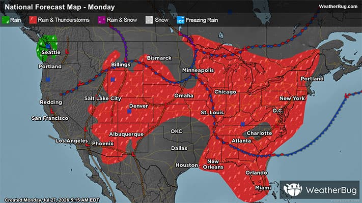
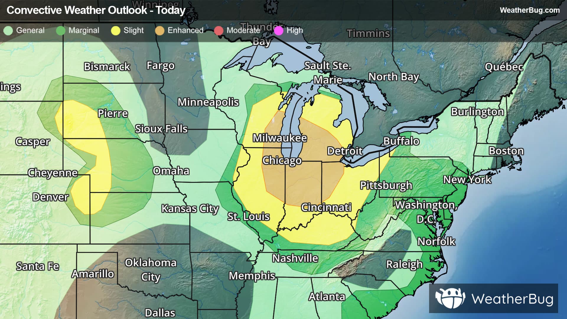
Strong to severe thunderstorms are expected to develop across the Great Lakes and Ohio Valley today.
Read More
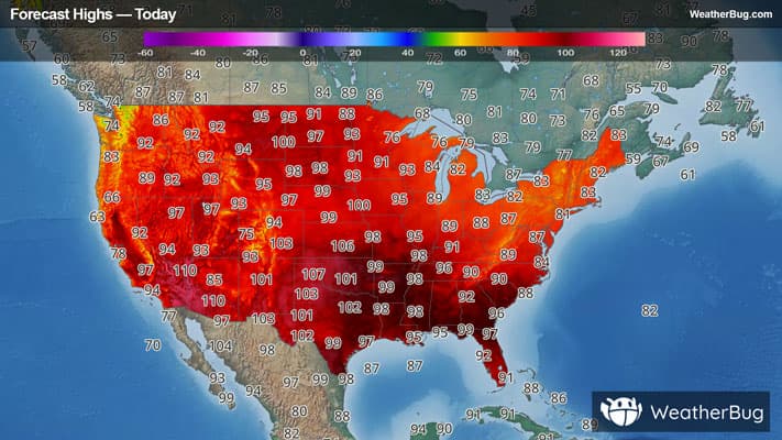
# HEADLINE -------------------- HEAT ADVISORY REMAINS IN EFFECT FROM 11 AM EDT /10 AM CDT/ THIS MORNING TO 8 PM EDT /7 PM CDT/ THIS EVENING EXTREME HEAT WATCH REMAINS IN EFFECT FROM TUESDAY MORNING THROUGH TUESDAY EVENING # DETAILS -------------------- WHAT For the Heat Advisory, heat index values up to 112 expected. For the Extreme Heat Watch, dangerously hot conditions with heat index values up to 115 possible. WHERE Portions of Big Bend and Panhandle Florida. WHEN For the Heat Advisory, from 11 AM EDT /10 AM CDT/ this morning to 8 PM EDT /7 PM CDT/ this evening. For the Extreme Heat Watch, from Tuesday morning through Tuesday evening. IMPACTS Heat related illnesses increase significantly during extreme heat and high humidity events, particularly for those working or participating in outdoor activities. Hot temperatures and high humidity may cause heat illnesses. ISSUED AT Monday, July 27, 2026 at 1:08 AM EDT ISSUED BY National Weather Service Tallahassee FL HEADER URGENT - WEATHER MESSAGE # PRECAUTIONARY/PREPAREDNESS ACTIONS -------------------- Drink plenty of fluids, stay in an air-conditioned room, stay out of the sunshine, and check up on relatives and neighbors. Young children and pets should never be left unattended in vehicles under any circumstances. This is especially true during warm or hot weather when car interiors can reach lethal temperatures in a matter of minutes. Take extra precautions if you work or spend time outside. When possible reschedule strenuous activities to early morning or evening. Know the signs and symptoms of heat exhaustion and heat stroke. Wear lightweight and loose fitting clothing when possible. To reduce risk during outdoor work, the Occupational Safety and Health Administration recommends scheduling frequent rest breaks in shaded or air conditioned environments. Anyone overcome by heat should be moved to a cool and shaded location. Heat stroke is an emergency! Call 9 1 1. # AREAS AFFECTED -------------------- Calhoun, Inland Wakulla, Southern Liberty, Central Walton, Coastal Bay, Coastal Franklin, Coastal Gulf, Coastal Jefferson, Coastal Wakulla, Gadsden, Holmes, Inland Bay, Inland Franklin, Inland Gulf, Inland Jefferson, Jackson, Leon, North Walton, Northern Liberty, South Walton, Washington Including the cities of Crystal Lake, Bradfordville, Honeyville, Bunker, Dalkeith, Malone, Capps, Sopchoppy, Southport, Beacon Hill, Santa Clara, Saint Marks, Medart, Vilas, Port Leon, Five Points, Center Ridge, Littman, Hays Place, Magnolia Beach, Panacea, Tilton, Durham, Abe Springs, Blountstown, High Bluff, Sumatra, Kern, Central City, Glendale, Dills, Bay City, Cluster Springs, Barker Store, Sweetwater, New Hope, Port St. Joe, Quincy, Maclay State Gardens, Drifton, Vicksburg, Odena, Bennett, Browntown, Scotts Ferry, Alma, Tallahassee, Panama City, Saint Joe Beach, Creels, Sandestin, Point Washington, Youngstown, Wetumpka, Richter Crossroads, Casa Blanco, Holmes County Airport, Cairo, Quincy Airport, Bethel, Portland, Callaway, Lynn Haven, Santa Rosa Beach, Marysville, Simsville, Morgan Place, Lewis, Buck Siding, Argyle, Oak Grove, Alpine Heights, Leonia, Chattahoochee, Festus, White City, Chipley Municipal Airport, Pleasant Ridge, Eucheeanna, Hilliardville, Marianna, Chaires Crossroads, Wilma, De Funiak Spring Airport, Killearn Estates, Capitola, Frink, Turquoise Beach, Hardin Heights, Twin Pole, Buckhorn, De Funiak Springs, Jarrott, Chaires, Freeport, Chipley, Apalachicola, Monticello, Fort Gadsden, Howard Creek, Cobb Crossroads, Apalachicola Airport, Nixon, Overstreet, Poplar Head, Beverly, Killearn Lakes, Sneads, Econfina, Wakulla Springs, Wewahitchka, Clarksville, Graceville, Bonifay, and Orange Hill
# HEADLINE -------------------- HEAT ADVISORY REMAINS IN EFFECT FROM 11 AM EDT /10 AM CDT/ THIS MORNING TO 8 PM EDT /7 PM CDT/ THIS EVENING EXTREME HEAT WATCH REMAINS IN EFFECT FROM TUESDAY MORNING THROUGH TUESDAY EVENING # DETAILS -------------------- WHAT For the Heat Advisory, heat index values up to 112 expected. For the Extreme Heat Watch, dangerously hot conditions with heat index values up to 115 possible. WHERE Portions of Big Bend and Panhandle Florida. WHEN For the Heat Advisory, from 11 AM EDT /10 AM CDT/ this morning to 8 PM EDT /7 PM CDT/ this evening. For the Extreme Heat Watch, from Tuesday morning through Tuesday evening. IMPACTS Heat related illnesses increase significantly during extreme heat and high humidity events, particularly for those working or participating in outdoor activities. Hot temperatures and high humidity may cause heat illnesses. ISSUED AT Monday, July 27, 2026 at 1:08 AM EDT ISSUED BY National Weather Service Tallahassee FL HEADER URGENT - WEATHER MESSAGE # PRECAUTIONARY/PREPAREDNESS ACTIONS -------------------- Drink plenty of fluids, stay in an air-conditioned room, stay out of the sunshine, and check up on relatives and neighbors. Young children and pets should never be left unattended in vehicles under any circumstances. This is especially true during warm or hot weather when car interiors can reach lethal temperatures in a matter of minutes. Take extra precautions if you work or spend time outside. When possible reschedule strenuous activities to early morning or evening. Know the signs and symptoms of heat exhaustion and heat stroke. Wear lightweight and loose fitting clothing when possible. To reduce risk during outdoor work, the Occupational Safety and Health Administration recommends scheduling frequent rest breaks in shaded or air conditioned environments. Anyone overcome by heat should be moved to a cool and shaded location. Heat stroke is an emergency! Call 9 1 1. # AREAS AFFECTED -------------------- Calhoun, Inland Wakulla, Southern Liberty, Central Walton, Coastal Bay, Coastal Franklin, Coastal Gulf, Coastal Jefferson, Coastal Wakulla, Gadsden, Holmes, Inland Bay, Inland Franklin, Inland Gulf, Inland Jefferson, Jackson, Leon, North Walton, Northern Liberty, South Walton, Washington Including the cities of Crystal Lake, Bradfordville, Honeyville, Bunker, Dalkeith, Malone, Capps, Sopchoppy, Southport, Beacon Hill, Santa Clara, Saint Marks, Medart, Vilas, Port Leon, Five Points, Center Ridge, Littman, Hays Place, Magnolia Beach, Panacea, Tilton, Durham, Abe Springs, Blountstown, High Bluff, Sumatra, Kern, Central City, Glendale, Dills, Bay City, Cluster Springs, Barker Store, Sweetwater, New Hope, Port St. Joe, Quincy, Maclay State Gardens, Drifton, Vicksburg, Odena, Bennett, Browntown, Scotts Ferry, Alma, Tallahassee, Panama City, Saint Joe Beach, Creels, Sandestin, Point Washington, Youngstown, Wetumpka, Richter Crossroads, Casa Blanco, Holmes County Airport, Cairo, Quincy Airport, Bethel, Portland, Callaway, Lynn Haven, Santa Rosa Beach, Marysville, Simsville, Morgan Place, Lewis, Buck Siding, Argyle, Oak Grove, Alpine Heights, Leonia, Chattahoochee, Festus, White City, Chipley Municipal Airport, Pleasant Ridge, Eucheeanna, Hilliardville, Marianna, Chaires Crossroads, Wilma, De Funiak Spring Airport, Killearn Estates, Capitola, Frink, Turquoise Beach, Hardin Heights, Twin Pole, Buckhorn, De Funiak Springs, Jarrott, Chaires, Freeport, Chipley, Apalachicola, Monticello, Fort Gadsden, Howard Creek, Cobb Crossroads, Apalachicola Airport, Nixon, Overstreet, Poplar Head, Beverly, Killearn Lakes, Sneads, Econfina, Wakulla Springs, Wewahitchka, Clarksville, Graceville, Bonifay, and Orange Hill