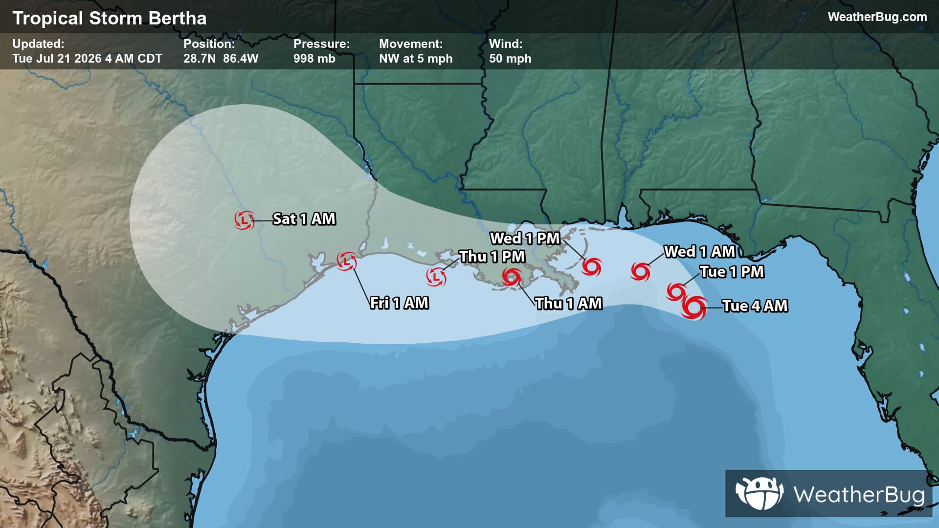
Weather Alerts For Río Abajo, PRI
Nearby Special Weather Statement
-A Weather Alert has been issued for a nearby area. While your current location is outside of the impacted area, please stay alert and monitor weather conditions. Special Weather Statement National Weather Service San Juan PR 258 PM AST Tue Dec 16 2025 Northwest PR-North Central PR-Mayaguez and Vicinity PR- Western Interior PR- 258 PM AST Tue Dec 16 2025 ...STRONG THUNDERSTORMS WILL IMPACT NORTHWEST TO NORTH CENTRAL MUNICIPALITIES THROUGH 345 PM AST... At 257 PM AST, Doppler radar was tracking strong thunderstorms along a line extending from near Lares to Arecibo. Movement was northwest at 10 mph. HAZARD...Wind gusts up to 40 mph. SOURCE...Radar indicated. IMPACT...Gusty winds could knock down tree limbs and blow around unsecured objects. PRECAUTIONARY/PREPAREDNESS ACTIONS... Torrential rainfall is also occurring with these storms and may lead to localized flooding. Do not drive your vehicle through flooded roadways. Frequent cloud to ground lightning is occurring with these storms. Lightning can strike 10 miles away from a thunderstorm. Seek a safe shelter inside a building or vehicle. To report severe weather, contact your nearest law enforcement agency. They will relay your report to the National Weather Service office in San Juan. &&
Rip Current Statement
-Coastal Hazard Message National Weather Service San Juan PR 1149 AM AST Tue Dec 16 2025 San Juan and Vicinity-Northeast-North Central-Northwest- 1149 AM AST Tue Dec 16 2025 ...HIGH RIP CURRENT RISK NOW IN EFFECT FROM 6 PM AST THIS EVENING THROUGH LATE WEDNESDAY NIGHT... * WHAT...High Rip Current Risk, life-threatening rip current. * WHERE...Along the exposed north-facing beaches. * WHEN...From this evening onward. * IMPACTS...Rip currents can sweep even the best swimmers away from shore into deeper water, where it becomes difficult to return to safety. * ADDITIONAL DETAILS...Stay tuned for updates as conditions will worsen on Wednesday. PRECAUTIONARY/PREPAREDNESS ACTIONS... There is a high risk of rip currents. Rip currents are powerful channels of water flowing quickly away from shore, which occur most often at low spots or breaks in the sandbar and in the vicinity of structures such as groins, jetties and piers. Heed the advice of lifeguards, beach patrol flags and signs. If you become caught in a rip current, yell for help. Remain calm, do not exhaust yourself and stay afloat while waiting for help. If you have to swim out of a rip current, swim parallel to shore and back toward the beach when possible. Do not attempt to swim directly against a rip current as you will tire quickly. &&
Lightning Alert
-Closest strike: 6.88 miles Stay Alert! Remain in a safe area until there has been no lightning within 10 miles of this location for 30 minutes. Please be aware that lightning activity can remain high even when a storm is moving away from your location. Even if rain has stopped, do not leave your safe area until WeatherBug indicates that lightning is more than 10 miles away from this selected location. IF OUTDOORS Avoid water, high ground, and open spaces. Avoid all metal objects including electric wires, fences, and machinery. Find a safe area in a building or in a fully enclosed vehicle with the windows completely shut. Unsafe places include underneath canopies, small picnic or rain shelters, convertibles, or near trees. IF INDOORS Avoid water and stay away from doors and windows. Avoid using a hard line telephone. Take off headphones. Turn off, unplug, and stay away from appliances, computers, power tools, and TV sets. Lightning may strike exterior electric and phone lines, inducing shocks to inside equipment.