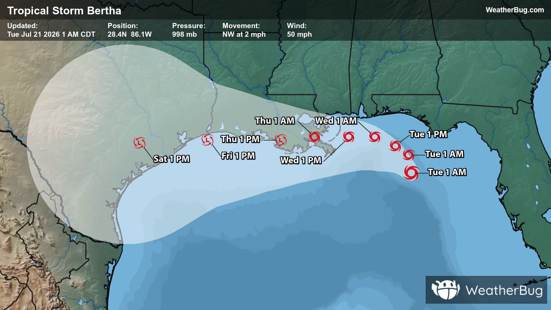
Severe Storm Risk - Farmington, KY
Severe Storm Risk
-There is a Marginal Severe Storm Risk for your location. Continue reading for today's outlook from the National Weather Service's Storm Prediction Center. -------------------- National Severe Storm Outlook THERE IS A MARGINAL RISK OF SEVERE THUNDERSTORMS ACROSS PARTS OF THE MISSISSIPPI/TENNESSEE/LOWER OHIO VALLEYS...AND PORTIONS OF COASTAL NORTH CAROLINA SUMMARY Isolated strong to severe thunderstorms capable of producing occasional damaging winds and perhaps a tornado or two may occur through this evening across parts of the lower/mid Mississippi Valley into the Tennessee Valley/Southeast, and late tonight across portions of coastal North Carolina. Tennessee Valley/Lower Ohio Valley into the Southeast A pronounced mid/upper-level shortwave trough with attendant 70-90 kt mid-level jet will advance quickly eastward today across the Upper Midwest into the MS/OH/TN Valleys. An associated deep surface low over northern MN this morning is forecast to continue developing northeastward into Ontario/Quebec through tonight, with a trailing cold front forecast to sweep east-southeastward over much of the mid/lower MS Valley into the OH/TN Valleys and Southeast. Low-level moisture return ahead of the cold front remains quite limited, except for parts of MS/AL where low to mid 60s surface dewpoints are beginning to spread inland. Even so, wind fields remain quite favorable for thunderstorm organization, with ample low-level and deep-layer shear present. Current expectations are for a low-topped line of convection to further develop along the cold front through this afternoon/evening. Although instability is expected to remain minimal with northward extent into the OH/TN Valleys, there is still potential for strong to severe gusts that will be convectively enhanced beyond the already strong background gradient wind field. Some chance for a tornado may also exist across parts of MS/AL where greater instability/low-level moisture will reside. Given latest observational and guidance trends, a Marginal Risk has been included where the best potential for occasional strong to damaging winds is apparent. Coastal North Carolina Isolated strong to locally severe convection may occur late tonight through early Friday morning as an increasingly negative-tilt mid-level trough and a related robust strengthening of the deep-layer wind field approach eastern NC. The gradual modification and erosion of continental/cold air is a key uncertainty due to persistent surface high pressure along the East Coast into western Atlantic. Some guidance such as the 12Z NAM may be a bit too aggressive regarding late-night near-surface-based destabilization. Still, the main area of concern is for the immediate NC coastal areas/Outer Banks, where somewhat greater airmass modification/low-level moistening should occur amid strong low-level and deep-layer shear. If surface-based thunderstorms can form and spread northeastward across this area, they could pose a threat for isolated severe/damaging winds and perhaps a tornado. But, it is also possible that convectively enhanced wind gusts materialize inland (including Piedmont areas) in the predawn hours, although confidence in this occurring remains low.