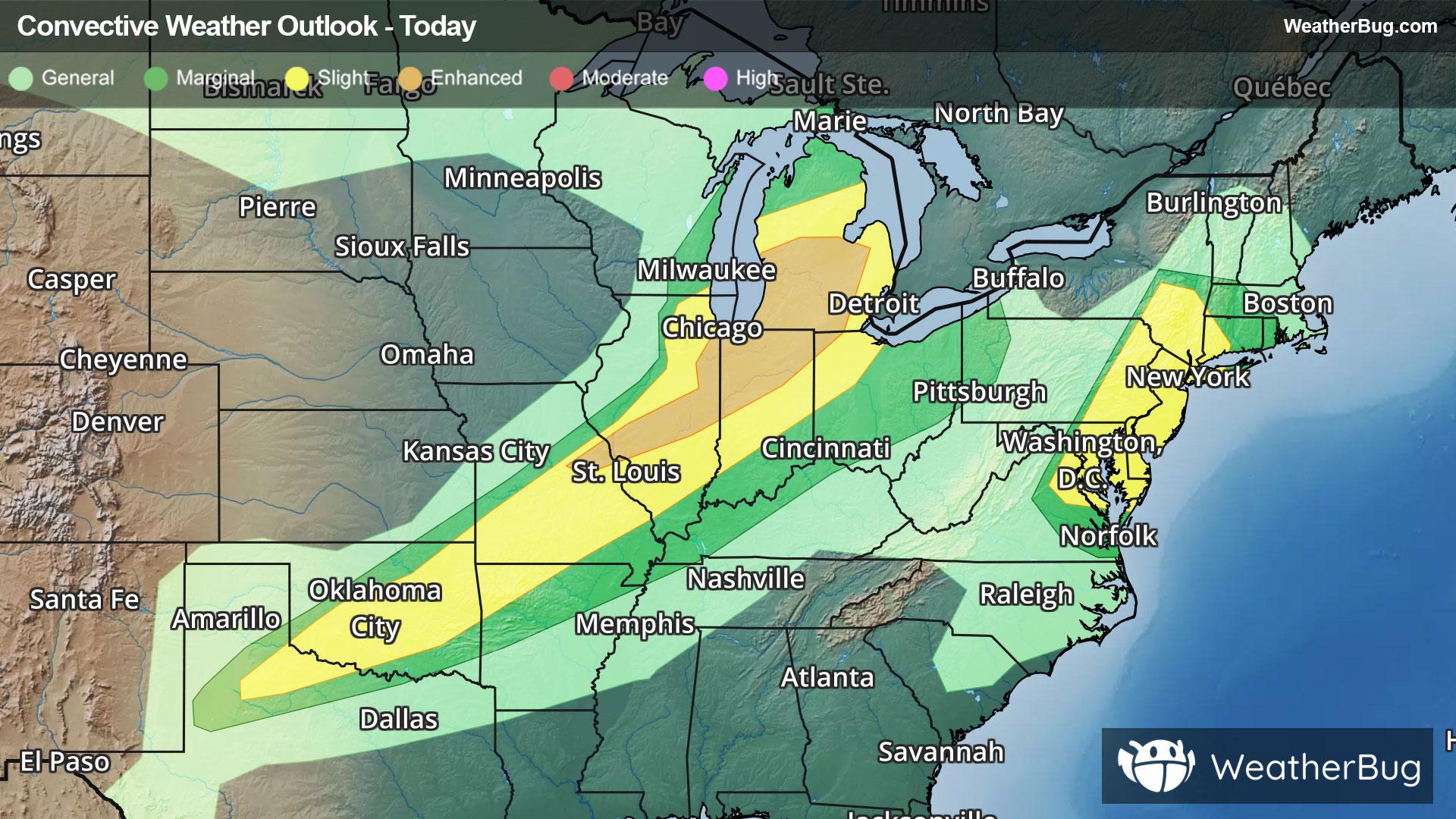
There is a Slight Severe Storm Risk for your location. Continue reading for today's outlook from the National Weather Service's Storm Prediction Center.
--------------------
National Severe Storm Outlook
THERE IS AN ENHANCED RISK OF SEVERE THUNDERSTORMS ACROSS PARTS OF THE MIDWEST/GREAT LAKES
THERE IS A SLIGHT RISK OF SEVERE THUNDERSTORMS FOR PARTS OF THE MID ATLANTIC
SUMMARY
Severe thunderstorms will continue this evening across parts of the Midwest and Great Lakes region. This includes the potential for tornadoes (possibly strong), widespread/intense damaging winds (some 75+ mph), and isolated hail.
Parts of the Midwest/Great Lakes
A rather volatile environment remains in place this evening across parts of IL/IN and southwest Lower MI, especially in the vicinity of a modified outflow across northern IL/IN. Rich low-level moisture, moderate to strong buoyancy, and strong low-level shear/SRH will continue to support all severe hazards through much of the evening. Convection has largely taken on a linear or cluster mode, with an attendant threat of severe/damaging gusts and line-embedded tornadoes. Any discrete cells that can be maintained within or ahead of ongoing convection will continue to pose a conditional strong-tornado threat, along with isolated hail potential. See MCD 1101 and MCD 1102 for more information regarding the short-term threat in this area.
Increasing CINH and decreasing MLCAPE with eastward extent should eventually result in a weakening trend, though an organized severe threat may reach parts of southeast MI and western OH later tonight.
OK/TX into MO/northern AR
Scattered strong to locally severe storms are ongoing from parts of western/central OK into MO, generally along or just behind a southward moving cold front. Moderate to strong buoyancy and deep-layer shear of around 25-35 kt near the front will continue to support occasional storm organization and a continued threat of hail and localized severe gusts, though convection may increasingly become undercut by the front with time. An isolated severe threat may eventually spread toward the Red River into western/northern AR late tonight.
Mid Atlantic vicinity
Loosely organized storm clusters with a history of producing wind damage are approaching the Mid Atlantic coast this evening. While deep-layer shear will continue to be modest at best, a very warm/moist boundary layer and moderate buoyancy will continue to support potential for strong to locally severe gusts and scattered wind damage, before convection weakens and/or moves offshore later tonight.